Lower Wye Valley
001 The River Wye
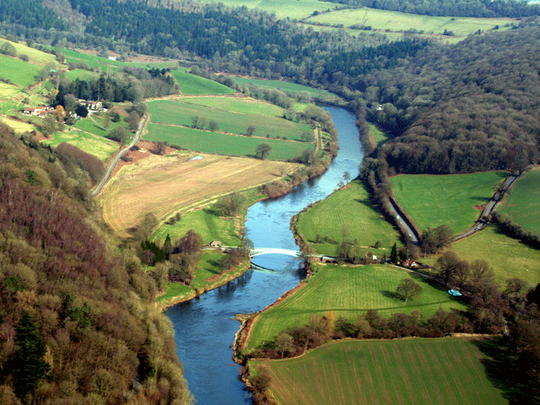
HLCA 001 The River Wye
Communication and coastal maritime corridor: bridges; weirs; fords; viaducts; ports/docks; ferries; harbour/fishing; ornamental/leisure and tourism; water supply resources. Back to map
Historic Background
The historic landscape area of the River Wye forms a natural communication route. The river is subject to tidal movement for 16km upstream from Chepstow and is navigable as far as Hereford beyond the Historic Landscape. The section of the river in question extends from south of Chepstow, the crossing point of the M48, to a bend in the river at the The Biblins, below Symonds Yat
The River Wye and its tributaries reflect human occupation stretching back through historic and prehistoric periods, and have acted as a vital communication route and have provided resources for industry. The earliest bridge crossing on the Wye dates to the Roman period; a wooden bridge is believed to have crossed the river approximately one kilometre north of Chepstow (Maylan 2000). At Monmouth the current seventeenth century Wye Bridge (PRN 01250g, NPRN 24231, LB 2220 Grade II) may have had medieval wooden precursor. The cast and wrought iron and red sandstone ashlar bridge (PRN 02192g, NPRN 24221, LB24916 Grade II) at Bigsweir was designed by Charles Hollis of London and constructed as part of the Wye Valley turnpike that opened in 1829.
The significance of the river as a transport route was greatly reduced following the construction of the turnpike road through the valley in the nineteenth century; the Bigsweir Bridge was in constructed as part of this turnpike road, which opened in 1829. The route of the turnpike road can be traced today along the line of the modern A466 road, which runs north through the valley providing an easier means of communication than the river.
The appreciation of the landscape of Britain and the historical popularity of the Wye in particular had its roots in the Picturesque movement. The development of the Wye as a tourist attraction was the direct result of the upheavals caused by the French Revolution and the Napoleonic Wars, which disrupted the Grand Tour favoured by the wealthy. Perhaps the most often cited and key text in the popularisation of the Wye Valley was William Gilpins work of 1782, Observations on the River Wye. Gilpins text served to promote the aesthetic qualities of the area, which grew in popularity during the later part of the eighteenth and beginning of the nineteenth centuries: the operation of eight pleasure boats on the river is recorded in 1808 (Maylan 2000).
Historic Landscape Characteristics
The River Wye is an area characterised as a natural communication corridor. The Wye and its associated river valley have an extensive history of human occupation and exploitation; the rivers fast flowing tributary streams have been harnessed over the centuries to power agricultural milling and heavy industry alike. A series of bridges, weirs, fords, viaducts, ports/docks and ferries of varying date are located within or extend into the area. These include the Chepstow Town Slipway (PRN 05478g, NPRN 401823, SAM MM301), and the Grade II listed bridges over the Wye (PRN 01250g NPRN 24231 LB 2220) at Monmouth and the Bridge (PRN 02192g, NPRN 24221, LB24916) at Bigsweir. The latter formed part of the early nineteenth century turnpike road developed by the Chepstow and Monmouth Turnpike Trustees.
Chepstow Town Slipway is the older of the two surviving slips that once served Chepstow and is an important surviving feature of the towns historic waterfront and quayside. It is an excellently preserved example of a post-medieval slip and comprises a cambered cobbled slipway that is bounded to the south by a low wall and to the north by a paved edge. Approximately 25m long by 2.6m wide, the final 0.5m of the slipway is formed of a flight of shallow steps down to the low-tide mark in the River Wye, the slipway spans two character areas: The River Wye (HLCA 001) and Chepstow (HLCA 003).
The river gorge and surrounding character areas that make up the Wye Valley Historic Landscape became important as a tourist attraction from the latter part of the eighteenth century. Strong literary, artistic and other historic associations with the Picturesque movement during the period have added to perceptions of the area. During the eighteenth century the scenic quality of the river gorge and associated romantic ruins, such as Tintern Abbey, drew considerable numbers of visitors down the Wye by boat to take in the magnificent unspoilt views, and the romantic atmosphere; tourism and leisure continue to be an important aspect of the areas character today.
The river provided a communication route for the transportation of materials to and from heavy industry situated along the faster flowing tributary streams. The physical form of the river and its banks has dictated the location of water-powered industry along the Wye. This boundary can be seen above and below Tintern, the point at which the river bank changes. Above Tintern, numerous water-powered industries are known to have existed, many surviving as relict archaeology. However, below Tintern, no such similar industries have developed, as much of the riverbank becomes difficult to access, at points the river flowing between gorges. The tidal range below Tintern is also greater, and there are no side tributaries.