Lower Wye Valley
021 Newton
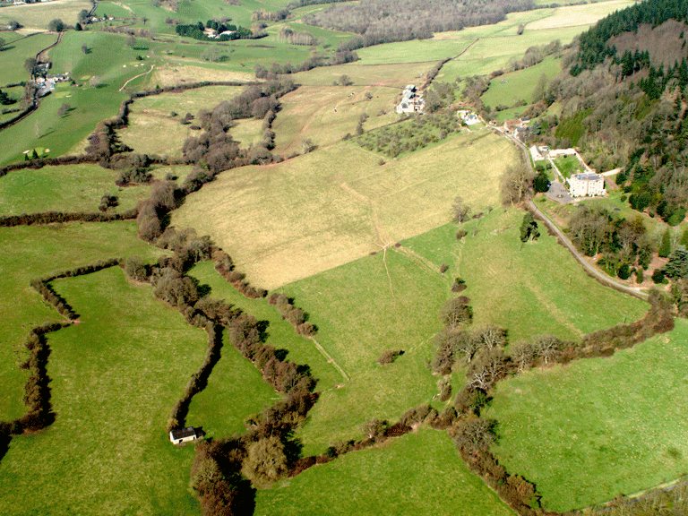
HLCA 021 Newton
Agricultural landscape: irregular pattern of irregular fields (minor 20th century amalgamation and sub-division); traditional boundaries; Medieval/Post-medieval settlement/fields: loosely dispersed settlement pattern of farms and cottages and a linear group of minor gentry houses (Newton Court and Hall); relict/buried industrial archaeology: medieval mill and metal processing sites (also additional potential for prehistoric, medieval and post-medieval buried features); communication features (sunken lanes); traditional boundaries (high mortared walls and earthen banks); historic associations; mixed woodland, and orchard. Back to map
Historic Background
The historic landscape area of Newton is an agricultural fieldscape, occupying the shallow valley of the Mally Brook; the boundaries are defined by the valley edges, the ancient woodland of Hayes Coppice to the north, and the line of the communication corridor to the east. The borders of this area are to an extent necessarily artificial, its character in fact extending well beyond the boundaries set for the historic landscape currently on the register of historic landscapes. The area lies within the parish of Dixton, within the manor of Dixton Newton.
There is little evidence for activity in the area before the medieval period, other than finds of prehistoric date (flints scatters: PRNs 03901g and 05655g). Medieval activity in the character area is suggested both by finds of pottery and evidence of iron smelting (PRNs 07983g, 03872g), and by a mention in the Doomsday Book of a mill possibly located in the area (PRN 05659g MAS 1996).
The principal settlement in the area consists of Newton Hall and Newton Court, the former is protected as a Grade II Listed Building, the latter is protected by Grade II* status (LB 85201, LB 85215). The earlier of these, Newton Hall, probably dates to the early seventeenth century, while Newton Court was built for George Griffin in the late eighteenth century. Architectural details, particularly the three full-height bows, suggests that it was built to a design by Anthony Keck, an architect who practised in and around Gloucestershire, though completed posthumously, as he died in 1797 (Newman 2000).
The land was purchased at the same time as the Dixton Hadnock area, by Admiral Griffin, and was left to his third son, who built Newton Court (Bradney 1904). The area remained in the hands of this family up to and beyond the date of the tithe map (1845) which lists the majority of the land here as belonging to Mary Griffin. The field pattern has altered substantially between the tithe and modern mapping (OS 2006 1:10000 Landline data) with amalgamation followed by later subdivision, although the land use has remained unchanged.
Historic Landscape Characteristics
Newton is now characterised largely as an agricultural landscape, comprising an evolved, irregular fieldscape of large fields. The fieldscape has been substantially altered since the tithe map (1843) with considerable amalgamation between this date and the First Edition OS (1881) followed by subsequent subdivision of the enclosures between this and the present (2006 OS Landline data). The state of cultivation, however, has remained similar, meadow, pasture and arable, with a small area of orchard in the northwest corner. The field boundaries, which characterise the area, consist of hedges and distinctive hedgerow trees.
Two important country houses, situated in an imposing position, on high ground overlooking the fieldscape, are strong features in the landscape and dominate its character. Settlement in the area can be traced to the fourteenth century, when there was a manor house here, possibly on the site of the present Newton Court (Rees 1932, SE sheet). Newton Court (PRN 02276g, LB 85215), built for the Griffin family in the late eighteenth century is a Neo-Classical house of coursed red sandstone with a slate roof with a three-storey central bay window in its main elevation (Newman 2000). Newton Court with its associated stables and screen wall is now protected as a Grade II* Listed Building, while the associated gate piers, gates and wing walls are separately listed (LB 85201 Grade II). These are also of red sandstone and in the Neo-Classical style, and are probably contemporary with the house.
A further feature of the characteristic settlement of the area is the Newton Hall complex, less than 200 metres further along Newton Court Lane. Although Newton Court is the principal residence of the area, Newton Hall (LB 85216) is also important, probably dating to the early seventeenth century, although significantly altered in the nineteenth century. Unlike the later Newton Court, it is constructed of stone rubble and rendered, with a slate roof. The wrought iron gates and railings are separately protected as Grade II Listed Buildings (LB 85202).
The secondary settlement in the area consists of a loosely dispersed scatter of cottages, lining the roads, which bound the area, all of which are in existence from the tithe map (1843) and are generally rendered with slate roofs.
The industrial activity within the area is represented from the medieval period by Dixton Mill (PRN 05659g, NPRN 40050), which is possibly referred to in the Doomsday Book (MAS 1996). There is further evidence for medieval industrial activity within the area, specifically iron working. Finds have been made within the area of iron smelting (PRN 07983g), while kiln waste (PRN 07984g) demonstrates continuity of industry in the area into the post-medieval period. The concentration of find spots recorded in the Historic Environment Record (PRNs 07983g, 07984g, 03872g, 03901g, 05655g) within the area suggests a high potential for buried archaeology.
The communication links in the area consist of sunken winding lanes bounded by high earth banks and very high, mortared walls.
Additional minor characteristics are possible historical associations suggested by the name of 'Gaol Barn'; this feature is depicted on the mid-nineteenth century tithe map, and named 'Gaol Barn' on the First Edition OS map (1882). Forestry also contributes to the character of the area, with stands of deciduous trees located around Newton Court, and areas of orchard are also evidenced in the historic mapping.