Lower Wye Valley
009 Tintern Ancient Woodland and Barbadoes Hill
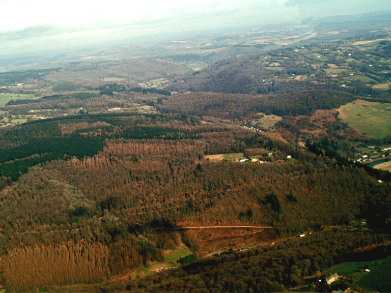
HLCA 009 Tintern Ancient Woodland and Barbadoes Hill
Ancient Woodland with scattered enclosures: post-medieval encroachment (eg. Barbadoes Hill); agri-industrial extraction and processing; relict archaeology: Prehistoric funerary and ritual and medieval/post-medieval settlement/fields; monastic associations (possibly Secular Firmary Grange and Coed-yr-Abad); historic associations; woodland management features/indications (potential). Back to map
Historic Background
The historic background of Tintern Ancient Woodland and Barbadoes Hill represents an area of contiguous mixed woodland, deciduous broadleaved and coniferous plantation located on the east-facing slopes above Tintern and to the south and north of the Angidy Valley, extending as far north as Whitelye, taking in Limekiln Wood, Church Grove, Glyn Wood, Ravensnest Wood, Buckle Wood, Upper and Lower Hale Woods, Barbadoes Wood, and Gurllus Grove. The woodland is largely semi-natural ancient woodland, though it includes some areas of replanted woodland. The area takes in a number of settlement encroachments, probably of post-medieval date, such as Barbadoes Hill, most of which have subsequently declined and been abandoned.
The earliest evidence for human activity in the area is evidenced by a group of three Bronze Age cairns, the Lower Hale Wood round barrow cemetery (SAM MM191; PRN 08049g and PRNs 03940g, 00724g 00725g) located within woodland to either side of what is probably an ancient ridge way route (now forestry track/public footpath) leading from Catbrook, via Whitelye to Tintern.
The secular firmary grange or hospital (PRN 08343g) associated with Tintern Abbey during the medieval period was established in the area to the west of Tintern above the Angidy Valley. This site, first identified as a manor in 1440 and later named as a grange, may have originated as a monastic hospital for local laypeople (Williams 1976, 120-1). Firmery Grove occurs at SO521999 (Williams 2001, 152 fig 65), and 'Chapel meadow' at ST522997 (Williams 2001, 311 no.169); a postulated chapel has also been identified (Evans 2004). An area of woodland known as Coed-yr-Abad (The Abbot's Wood) also relates to a former monastic land holding.
Also in the medieval period a road linking the abbey at Tintern with its outlying grange of Porthcasseg is believed to have been constructed through the area. Known as the Stony Way (PRN 03174g), this medieval cobbled road ran from Tintern Abbey, behind the later Beaufort Hotel, up towards the monastic manor of Porthcasseg. Named by 1451, the route is thought possibly unique in Gwent. It is likely that this road, which linked a number of the Abbey's outlying holdings, would have been constructed by lay brethren, fratres conversi and hired labourers, mercenarii.
Post-medieval settlement encroachment into the woodland is evident with a number of small isolated and outlying dwellings on the periphery of larger settlements, illustrated by the dwellings and associated small regular enclosures of Cliff Cottages (PRN 07126g) and other enclosures at Church Grove (PRN 07075g), including what appear to be animal pens or sheepfolds depicted on the First Edition OS map. These have largely been abandoned, though the settlement of Barbadoes Hill, an encroachment extant on the Tithe, remains largely unchanged and occupied. It is likely that the name Barbadoes Hill originated through an association with either the Morris family of Tintern, or with Nathaniel Wells, a later owner of Piercefield, all well connected to the Caribbean.
The three Morris brothers, Lewis, William and Richard, were all strongly associated with the Caribbean and the Americas. It is known that Lewis Morris, born c.1613, was variously privateer, ship's captain, and wealthy sugar plantation owner in Barbados, he also owned much of what is now the Bronx, and became an iron ore smelter in New Jersey (Smith 1983), while his brother William's son John took part in the Parliamentary expedition to Barbados in 1652. Colonel Valentine Morris, a descendant of John Morris, served on the Island of St Vincent in the Caribbean and bought the Piercefield estate in 1736, after retiring to Wales. The Morris family retained estates in the West Indies, and Valentine Morris's son, Valentine Morris the Younger, returned there after financial problems forced the sale of Piercefield. Valentine became Lieutenant-Governor and eventually Governor in Chief of St Vincent, prior to its loss to the French.
Nathaniel Wells (1779-1852), who inherited a fortune from his father, a plantation owner from St Kitts in the Caribbean, purchased the Piercefield estate in 1802. Nathaniel, who became Sheriff of Monmouthshire in 1818 and later Deputy Lieutenant, was of mixed parentage, his mother, Juggy, a former African slave, his father William Wells originally from Cardiff.
Historic Landscape Characteristics
Tintern Ancient Woodland and Barbadoes Hill is an area of woodland and forestry, which is characterised by ancient woodland dominated by coniferous and mixed deciduous and other broadleaf woodland. The area encompasses several scattered enclosures and other features associated with Tintern Abbey. The coniferous woodland is generally limited to the upper reaches of the broader hill slope and the mixed deciduous woodland to the lower reaches of the narrower hill slope above the Angidy valley (HLCA 014).
Relict archaeology is a dominant characteristic of the area, surviving in the form of Hale Wood Round Barrow Cemetery (SAM MM191; PRN 08409g) dating to the Bronze Age. Two of these cairns are heavily eroded and may have been robbed for material to build or repair nearby tracks, while adjacent forestry has encroached on the monument. The best-preserved cairn (PRN 00725g), located to the south of the trackway, is the largest of the group and is recorded as being oval in shape. These relict archaeological features, now protected through scheduling, provide a funerary and ritual aspect to the character of the area.
Settlement in the area is characterised by scattered isolated post-medieval encroachment of homesteads and associated enclosure in place by the survey of the First Edition OS map (eg, PRNs 07125g, 07126g, 07274g and 07075g). The proximity of these holdings to settlement in adjacent areas, for example and those within Tintern Abbey (HLCA 013) and Angidy Valley (HLCA 014) suggests in some instances that these outlying settlement features in fact originated as settlement expansion from settlement in neighbouring character areas. One such example is the abandoned dwelling (PRN 07125g) located on the northeast-facing hill slope above Tintern Abbey; this comprised two buildings with associated enclosed fields. Other examples include a single abandoned building (PRN 07126g) that appears to have been part of a group of two or more structures named Cliff Cottages on the First Edition OS, another also abandoned (PRN 07274g), appears to have been revetted into the hillside. A further abandoned dwelling (PRN 07075g) survives as part of a group of features located on the lower reaches of the south-facing woodland slope at Church Grove.
The settlement of Barbadoes Hill, a good example of post-medieval encroachment, is little changed from that depicted on the tithe and the First Edition OS maps, barring minor additions. The area, which contains a small number of rectangular dwellings with associated enclosures, including Yew Tree Cottage, all have their main axis located along the slope, as opposed to the more traditional down slope layout; this is a good indication, along with the name, Barbadoes Hill (a reference to the area's connection with sugar plantations in the Caribbean) that the settlement is not earlier than seventeenth century, and more likely late eighteenth, or even early nineteenth century in date. The tithe apportionment records that the majority of enclosures associated with the settlement of Barbadoes Hill were in use as orchards, no doubt for the local cider industry.
Other characteristics derive from agri-industrial extraction and processing, in the form of limekilns and small-scale quarries. A good example is the Colwell Grove Limekiln (SAM MM290; PRN 07507g), described as 'a fine example of an important regional limekiln type in its complete setting.' This is a remarkably complete example of the Wye Valley type limekiln dating to the early nineteenth century with surviving associated landscape features, including trackways, ramps, walls and associated quarry (SAM MM290; PRN 7508g). The kiln has two drawing arches to the front, fed by a single pot. Some of the upper face has fallen away but the arches and pot are intact. A holloway bounded by substantial walls leads up to the kiln. Limestone may have been dug from a wide area around the kiln, and a well-preserved quarry lies to the south. It is likely that these features will have had a role in the development of the wider historic landscape as a whole providing materials for building and agricultural improvement.
Communication and transport routes add to the character of this area: the medieval road, (PRN 03174g) the Stony Way that runs from the grounds of Tintern Abbey to its associated manor of Porthcasseg is believed to run though this area, while some of the ridgeway routes in the area may be prehistoric in origin. Little is known about the area's forest trackways, and paths, many of which are public rights of way; many may well have early origins, while others may relate to the industrial exploitation of the Angidy Valley from the medieval and in particular from the early post-medieval period.
The area would benefit from further in depth study (and field survey) on this and other aspects, such as the nature of enclosure and encroachment within the woodland, and features associated with or indicative of past woodland management, likely though as yet to be comprehensively identified in the area.