Lower Wye Valley
010 Dixton Transport Corridor
HLCA 010 Dixton Transport Corridor
Transport and communication corridor: roads (Roman and post-medieval) and associated features; public rail; Post-medieval settlement and fields: settlement pattern dispersed farmhouses and cottages, and church; field pattern: regular; traditional boundaries; ecclesiastical features: medieval church and associated cemetery (on early medieval monastic site); relict/buried archaeology (Prehistoric/Roman and Medieval); education; industrial archaeology: metal processing, mill and cider house. Back to map
Historic Background
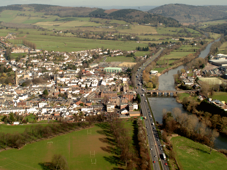
The historic landscape of Dixton Transport Corridor is a long narrow area on the west bank of the River Wye that runs from north to south and wraps around the east of Monmouth. The area encompasses several transport and communication routes and falls historically within the parish of Monmouth. A number of maritime features of post-medieval date exist at the edge of this character area to the east of the main town of Monmouth.
Finds of a flint knife (PRN 04511g) and a bronze axe (PRN 03733g) dating to the Neolithic and Bronze Age respectively provide the earliest evidence for activity in the area, though this is somewhat transient in nature. A road of the Roman period, the Monmouth-Weston under Penyard (Monmouth-Ariconium) road, a branch of the Antonine Itinerary XIII, (PRN 02954g, RR612a-03) runs through the area (Margary 1957; RCAHMW 1994; Sherman and Evans 2004). This road is believed to be a continuation of the road from Caerleon running north from Monmouth towards Hereford.
The establishment of a church (now St Peter's PRN 01233g), at Dixton during the early medieval period is indicated by documents of c. AD 735, in the Llandaff Charters. The Norman foundation of St Michael's Chapel and Hospital (PRNs 02267g and 02266g; Evans 2004) represents further ecclesiastic development in the area. During the post-medieval period a rectory was constructed to serve St Peter's Church; the building is depicted just north of the church on the mid-nineteenth century Dixton tithe map (1849) and noted as a house, garden and offices belonging to Mary Griffin, the First and Second Edition OS maps name it as the Rectory and by the Third Edition it is known as Dixton Cottage.
Associated with the Turnpike Road to Monmouth of 1829 is Dixton Gate Turnpike (LB 2315; Grade II), a surviving tollhouse. The site of the latter is located just north of the Turnpike Road, 'The Old Dixton Road', the route of which exits the town on the east, which is the same as the medieval route shown on John Speed's map of 1610, and likely to be that of the Roman road which preceded it.
The New Dixton Road (formerly part of the A40, now the current A466), visible in historic mapping from at least the mid-nineteenth century (Dixton tithe map of 1849), is also detailed on the 1881 First Edition OS and later maps, and provides the northern boundary of the area. In 1965-6, following the closure of the Wye Valley Railway, the current A40 by-pass was constructed, diverting the A40 south of the town from a roundabout junction at Dixton.
The southwestern limits of the area contain the line of the Wye Valley Railway from Monmouth to Ross on Wye, the site of Troy Station, and Troy viaduct. The line from Wyesham crossed the Wye to Troy (over the now listed Mayhill railway bridge) and then re-crossed the Wye (via a viaduct east of Troy House) to continue its route south. The Wye Valley Railway, opened on the 4th of August 1873, was built by the Ross & Monmouth Railway under an Act of the 5th of July 1865 and originally terminated at May Hill station and it was not until May 1874 that the Great Western Railway opened the ¾-mile extension to Troy (Monmouth) Station. The Great Western Railway worked the line, which remained under the nominal control of the Wye Valley Railway, until 1922.
Today the area, which contains Monmouth Comprehensive School, is generally in use as a transport corridor.
Historic Landscape Characteristics
Dixton Transport Corridor is an area characterised by communication and transport routes, all visible from at least the 1881 First Edition OS map. These transport routes include the Wye Valley Railway and its station at Troy (Monmouth Station), associated bridge and viaduct, and series of roads, including the probable line of the Roman Road, the later medieval route (Old Dixton Road) and the mid-nineteenth century New Dixton Road (A466), and the A40 and modern A40 Monmouth by-pass.
Other elements within the area emphasising communication include the line of the turnpike road, an associated tollhouse, Dixton Gate Turnpike (LB 2315; Grade II), an exceptionally well-preserved example, comprising a three-bay structure, with a two-storey central bay of roughly rendered and painted construction under a slate roof.
The settlement of this area is characterised by dispersed post-medieval farmhouses and cottages (Rectory and Chapel Farm), and the medieval church of St Peter's, Dixton, within an associated field pattern of regular rectangular enclosures and strips along the banks of the Wye.
Ecclesiastical character is provided by St Peter's, Dixton (PRN 01223g) and St Michael's Chapel and Hospital (PRNs 02267g and 02266g). The church of St Peter's at Dixton, which may have originated as part of an early medieval monastic establishment and is first mentioned in the Llandaff Charters, is located at the north of a sub-rectangular churchyard, and consists simply of nave, separate chancel, west tower, and north and south porches; there is also a vestry to the east of the north porch. Render and plaster cover much of the church building that stands today, and as a result is difficult to date the structure. However internally within the nave there are areas of exposed herringbone masonry, which indicate a likely early date for construction (Evans 2004).
St Michael's Chapel and Hospital (PRNs 02267g and 02266g) dates from the medieval period and generally believed to be a Norman foundation. The site is also known as 'chapel farm' (Evans 2004).
The medieval Churchyard Cross (PRNs 08270g; 08273g; 08118g; LB 85192, Grade II; SAM MM308) at St Peter's, Dixton, survives as a single step surmounted by octagonal socket-stone and cross-shaft, it has been suggested that this may have been brought to the site from Wyesham (Kissack 1974), see Wyesham (HLCA 035). Also of note is the former rectory associated with St Peter's Church recorded as Old Dixton Cottage (PRN 04155g).
The field pattern within this area originates from the post-medieval period and consists generally of strips of land running down to the riverside from the westernmost edge of the area; the boundaries that divide up these fields consist of a mix of distinctive hedgerow trees and post and wire fencing.
Also, Monmouth Comprehensive School provides a more recent educational characteristic with structures surviving from the three main phases in the school's development. These are an original building of 1903, the former William Jones Elementary School (probably designed by Henry Stock), constructed for the Haberdashers' Company. Described as 'simple, gabled, single-storeyed, in pink rock-faced sandstone'. Next, buildings erected 1964-5 (Secondary Modern phase), by the Monmouthshire County Architect's Department, County Architect Sydney Leyshon, typically in the style of undemonstrative Modernism, and finally two- and single-storey classroom blocks dating to the expansion of the school carried out in 19767, for the conversion to Comprehensive status in 1977 (job architect N Robson-Smith, Gwent County Architect's Department, County Architect K P Jones). The latter are in dark-brown brick with black-tiled monopitch roofs (Newman 2000, 404).
Other minor features, which contribute to the character of the area, include relict/buried industrial archaeological features, such as the bloomery at the east gate to Monmouth (PRN 01237g), where a large amount of iron slag and cinders have been recovered; believed to be of medieval origin, this is potentially the site of a forge belonging to William de Marias. Post-medieval mapping indicates a timber yard existed in the area; this formerly stood on the southeast edge of Monmouth. Also evidence of agri-industrial activity exists at Chapel Farm where a post-medieval cider house (PRN 02269g) and water mill (PRN 02268g) are located.
The River Wye forms the southern boundary of the character area, and has historically provided a major communication route, whilst the River Monnow crosses the south of the area. A number of maritime features (including wharves, posts near the timber yard mentioned above visible on the edge of this character area to the south east of Monmouth) are also noted in historic mapping from at least the 1881 First Edition OS map.