Historic Landscape Characterisation
Gower
The Gower peninsula is a clearly defined geographical area containing a variety of landscapes from steep limestone cliffs and secluded sandy bays on the south coast, long and magnificent sands and spectacular headlands to the west, and sand dunes and saltwater marshes along the north coast. Inland, the gently rolling coastal plateau gives way to higher hills and ridges such as the dominant Cefn Bryn which cuts the peninsula neatly into two, though these features seldom rise beyond 180m above OD. Within this Area of Outstanding Natural Beauty, the first in Britain (1956), there are archaeological sites of most periods, from occupied Upper Palaeolithic caves through to medieval castles and an en-parked 18th century landscape and industrial monuments, representing an unrivalled microcosm of Wales's historic wealth.The two best surviving and most complete, close but topographically discrete, archaeologically rich areas of the peninsula have been identified here.
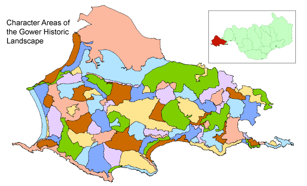
Use the map to select your area of interest or go directly to character area summaries.
West Gower
The variety of the geology and topography in the western peninsula area is remarkable and closely linked to man's exploitation of the area from the Upper Palaeolithic through to the present day. Archaeologically, the area is noted for the Upper Palaeolithic remains found at the Longhole and famous Paviland Caves and at Deborah's Hole which overlooked their hunting grounds on coastal plains long since inundated by the sea.Well-defined remains of Iron Age settlements and forts are notable features of the headland at the Knave and Thurba Head. There are also good examples of recent limekilns along this section of the coast, particularly at Thurba Head.The salthouse at Port-Eynon, which has recently been conserved, remains a unique example of a 16th century coastal saltworks.
Rhossili and the Rhossili Down area to the west are archaeologically very rich. In addition to the Iron Age promontory forts on the clifftops, Rhossili Down contains a number of Neolithic burial chambers and Bronze Age cairns. At the foot of the Down is the site of the deserted medieval village and former church of Rhossili, which were be-sanded in the later medieval period. The most significant survival, however, is the remarkable medieval open field system, known as the Vile. This arable area is approximately 390ha in extent and is divided into the characteristic medieval strips between 180m and 230m long and 15m to 70m wide. Each bundle of strips, with an average size of 0.6ha (1.5 acres), is arranged in roughly square blocks each having distinctive names such as Sandyland, Priest Hay and Bramble Bush.The field pattern is preserved today by the uncultivated baulks of earth and drystone-walls about lm wide, known as landshares.They have the appearance of raised paths and indeed were often used as such.The practically unique survival of this medieval open field system is of national importance, particularly as it remains under threat by present day enclosing activities.
Further north lies the Llangennith, Lagadranta and Broughton area of lowland moors, burrows, dunes and farmland,much of it being common land.The main archaeological interest is centred around Burry Holms, holm being a Nordic term for an island.The island contains a promontory fort of Iron Age date. There are also the remains of a chapel, indicating that there has been a religious settlement here at least since the Middle Ages. Inland, the church at Llangennith, itself the largest in Gower, is dedicated to St Kenyth who was reputedly washed ashore on Burry Holms. To the south of the church lay a medieval college and priory, making Llangennith one of the most notable medieval settlements on the Gower. Above and dominating Llangennith from the south east, is Hardings Down, which contains a number of important prehistoric sites, including two Iron Age hillforts in close proximity.
To the north lies the Burry estuary, a wide area of salt marsh in the tidal mouth of the River Loughor.The area is a hub of early settlement and many of the hills or promontories overlooking the estuary had their own fortified settlement such as The Bulwark to the south west of Cheriton.The settlements of Llanmadoc and Cheriton reflect Anglo-Norman influences on the landscape.The Church of St Cadog at Cheriton is acknowledged to be one of the most beautiful of the Gower churches.
Cefn Bryn
The prominent long ridge of Cefn Bryn dominates the skyline over much of the Gower. It rises to a maximum height of 188m above OD and extends 6.5km east to west between the settlements of Penmaen and Stembridge. It is undoubtedly one of the richest archaeological areas of South Wales, containing dense concentrations of monuments surviving on the crest and slopes of the ridge, and providing multiperiod evidence of human activity from at least the 4th or 3rd millennium BC.
Arthur's Stone near Reynoldston might have been a Neolithic chambered tomb for the communal burial of the dead. A temporary settlement, dating to the early 3rd millennium BC, has been excavated close to Arthur's Stone, at Great Carn, a later, Bronze Age funerary monument. Although Arthur's Stone, Great Carn and other structured cairns are the most conspicuous prehistoric sites on Cefn Bryn, there is plentiful evidence of large-scale clearance of the surface of the ridge for agriculture. Clusters of small cairns, probably the result of wholesale clearance, are recorded on the ridge with over 200 currently known .About a dozen burnt mound sites (distinctive turf-covered heaps of shattered burnt stones, charcoal and blackened earth) are known , located close to pools or streams where they possibly accumulated as the result of heating stones to boil water for communal cooking activities at various times during the prehistoric period. During the Iron Age, there is evidence of human settlement just outside the area at sites such as the hillforts or enclosures at Stembridge, Reynoldston, Crawley Woods and Cilifor.
The imposition of the manorial system on Gower in the medieval period was an important influence on the land use of Cefn Bryn which fell within the Welshry of the Lordship of Gower. Generally, the Welshry contained the poorer soils and Cefn Bryn was manorial waste over which commoners rights were established and exist to the present day. In the post-medieval period, attempts were made to improve the agricultural value of the common as is shown by the sod limekiln processes to produce lime to reduce soil acidity. Human exploitation of the common has continued to the present day with the construction of a number of military gun pits, reservoirs and quarries.