Lower Wye Valley
007 Livox Farm
HLCA 007 Livox Farm
Agricultural landscape (single farmstead): regular fieldscape: large rectangular enclosures; traditional boundaries; communication features; buried archaeology; monastic associations. Back to map
Historic Background
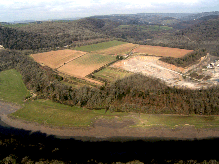
The historic landscape area of Livox Farm is an agricultural area to the north of Chepstow, located on the shallow sloping lower valley side at a sharp bend in the river, between the west bank of the Wye and the steep slope of the Wyndcliffe. The Wye at this point curves so sharply that it doubles back on itself, and encloses the shallow valley bottom on three sides. This agricultural landscape consists of a single small farm, which historically fell within the parish of Chapel Hill, and which, having been owned by the monks of Tintern, was tithe-free.
Prehistoric activity in the area is demonstrated by finds of two hoards dating to the Bronze Age, one consisting of two Brereton type socketed bronze axes and the second of seven socketed and looped axes (Maylan 1990).
The area was likely to have originally been heavily wooded, as the surrounding area still is, and probably represents an area of medieval assart. The area of Livox Farm, part of the manor at Porthcasseg, was among lands given to Tintern Abbey in AD 1131 by Walter de Clare. It is considered that the area was farmed from the nearby Rudding Grange (Reddings Farm in HLCA008), a grange of Tintern Abbey (Maylan 1990).
After the dissolution of the monasteries, the land of the Abbey was granted to the second Earl of Worcester in 1537 (Maylan 1990, 6) and remained in this family (who later became the Dukes of Beaufort) until it was leased in 1759 to the Piercefield Estate then under the ownership of Valentine Morris. When the Piercefield estate was sold to Colonel Mark Wood in 1793, Livox Farm extended over 134 acres; almost double its current extent of 82.97 acres (33.58 hectares); the farm had grown slightly to 140 acres by 1802, when the estate had been bought by Nathanial Wells. The farm buildings were described in the sale catalogue for Piercefield Estate, dating to 1793, as being 'recently erected'. The extant farm buildings appear to have survived with little alteration since the late eighteenth century, and it has been suggested that the farmstead represents a model farm of the eighteenth century (Maylan 1990, 12). The area remained in the ownership of the Beaufort family until 1901, when it was included in the sale of the estates of the ninth Duke, when the land here was amongst that purchased by the Crown (Bradney 1913).
As the parish of Chapel Hill was tithe-free there is no map dating to the 1840s, but the First Edition OS map (1881) shows the agricultural land to cover the same area as it did up to the late twentieth century, while the field pattern remains unchanged up to the date of the Third Edition OS map (1921). The latter half of the twentieth century saw some further minor alteration to the field layout; more profound changes, however, occurred in the 1990s with the expansion of Livox Quarry into the fields on the western side of the farm (Maylan 1990).
Historic Landscape Characteristics
Livox Farm can be characterised as an isolated area of agricultural activity that appears historically to have been won from the surrounding ancient woodland. Its agricultural fieldscape can be characterised as regular fieldscape of large rectangular enclosures, now apparently set down to arable and dry pasture/fodder. The boundaries comprise well-developed hedges with distinctive hedgerow trees augmented by post and wire fencing.
Historically the agricultural land at Livox will have been most likely won from the surrounding woodland through a process of assart. Ancient woodland today bounds the area on three sides, whilst to the east lies expanse of Livox Quarry, a limestone quarry, visible on historic mapping from at least the First Edition OS map; the quarry then depicted then was much smaller than current, and much of the area between the river edge and Livox Farm has now been removed by quarrying.
The settlement within the Livox Farm character area consists of an isolated post-medieval farmstead (PRN 05339g), appearing as 'Liveoaks Farm', until at least the 1921 Third Edition OS map (the name Livox appears to be a recent corruption of this earlier form that probably related to the surrounding woodland), along with four small cottages, which first appear on the 1921 OS map just inside the character area. The survey of the First Edition OS map indicates the farm was formerly laid out as follows: centrally dividing the farm are two main east-west aligned linear ranges (that to the west (extant) with short lateral projecting wings to the north and south sides, that to the east linear with a short wing extending north at the east end); to the north three detached buildings (including an L-shaped range) lie across a yard, with a further rectangular building beyond; to the south are two parallel ranges linked by two sub-rectangular yards to a third range to the east comprising a much extended building (with a staggered profile), possibly the original farmstead. Modern mapping and aerial photographs indicate that only two of the original structures survive on the site, with recent agri-industrial structures now a dominant feature.
Communication and transport routes also contribute to the character of this landscape area. Within the historic landscape character area, a single straight lane connects the farm buildings to an important external communication route that is the route of the A466; the river is inaccessible here as it enters a precipitous gorge.
There are a number of find spots in the area, object found include two hoards of Bronze Age axes (PRNs 00746g and 00747g), and medieval and post-medieval coinage (PRN's 05334g, 05335g, and 05336g); some of these finds might relate to buried archaeological remains, as yet unidentified, in the area.