
Historic Landscapes in Wales
The Glamorgan-Gwent Archaeological Trust has been involved in work examining the historic character of areas defined by the Register of Historic Landscapes in Wales.
This is part of an ongoing pan-Wales project sponsored by Cadw: Welsh Historic Monuments and the Countryside Council for Wales, and the background to this is outlined below. Once the landscapes on the Register have been fully characterised it is hoped to expand the work into the 'unregistered' parts of Wales. The following pages give a flavour of the work so far in the Glamorgan-Gwent area.
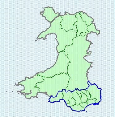
The area outlined in blue is Glamorgan-Gwent, which is being studied as part of the pan-Wales Historic Landscape Characterisation program.
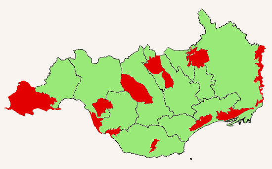
Areas of Historic landscape covered by the CCW / Cadw / ICOMOS UK Part 2.1 Register of Landscapes of Outstanding Historic Interest in Wales and the Part 2.2 Register of Landscapes of Special Historic Interest in Wales. The areas shown in red are those looked at in detail so far as part of the ongoing Historic Landscape Characterisation program in Wales. This map will be updated as further areas are studied. Click on the image below to link to the relevant Historic Landscape or select an area from the menu bar.
Natural forces and human activity acting together over the last six thousand years have contributed to produce a landscape of great beauty and variety in Wales, a national asset that is essential both to our national identity and to our individual 'sense of place and well being. The diversity and imprint of human activity on the landscape is everywhere to be seen, from the enigmatic stone monuments of the prehistoric period and the magnificent castles and abbeys of the medieval period, to quite commonplace and typical features like field boundaries that can often be of great age. But the landscape is more than just attractive scenery or a record of the past; it also provides a place for us to live, work and sustain ourselves, through farming, forestry, tourism and so on, processes that all shape, and will continue to shape, the landscape.
Recognising and raising awareness of the importance and wealth of the historic fabric of the landscape has been the central theme and message of the non-statutory, Register of Landscapes of Historic Interest in Wales, the first part of which, covering thirty-six 'outstanding' landscapes, was published in January 1998. This is being compiled as a joint initiative between Cadw: Welsh historic monuments, the countryside council for Wales (CCW) and the International Council on monuments and sites (ICOMOS), working in collaboration with the four Welsh Archaeological Trusts, the Royal Commission on the Ancient and Historical Monuments of Wales and the Welsh unitary authorities.
The Historic Landscapes Register provides a first step, national overview of the historic content of the Welsh landscape. The next step, so essential to the process of informing the way in which aspects of the historic landscape may be managed, is to make available more detailed information about the character of this landscape at a more local level. This is achieved through a process known as historic landscape characterization, which has been developed in Wales jointly by Cadw, the CCW and the Welsh Archaeological Trusts. This involves the identification of geographically definable and mapable areas of historic character, as determined by the range and distribution of surviving archaeological and historical features and the main types of historical land use patterns or historic'themes' that have shaped the area. The key historic characteristics of the area are then identified along with recommendations for their positive management.
This report is one of a series of historic landscape characterisation exercises being undertaken by the Welsh archaeological Trusts with grant-aid from Cadw. These studies will initially concentrate on those areas identified on the Historic Landscapes Register, although it is accepted that the whole of the Welsh landscape can be said to be, in one way or another, historic. Information is being prepared in a form, which is compatible to the CCW's landscape assessment and decision-making methodology, known as LANDMAP. It will be made available to a wide range of organisations and will feed into various initiatives to protect and manage the Welsh countryside, most notably the Tir Gofal agri-environmental scheme. It is also seen as making a particularly important contribution to raising awareness and heightening a feeling of local distinctiveness.
The Historic Landscapes Register and these characterisation exercises fully acknowledge the dynamic and evolving nature of the landscape. They promote the view that protecting the legacy of the past in the landscape is not to be achieved by preventing change or fossilising the landscape but rather by informing the process of change, creating tomorrow's landscapes, without necessarily sacrificing the best of yesterday's.