Lower Wye Valley
031 Kymin Naval Temple
HLCA 031 Kymin Naval Temple
Registered parkland and garden with commemorative temple: ornamental/leisure (tower/folly/viewpoint); distinctive building type: picturesque pavilion and memorial; historic associations: persons; events; and 'Picturesque' Movement; tourism (National Trust property); Ancient Woodland; communication features. Back to map
Historic Background
The historic landscape area of Kymin Naval Temple, a small discrete area of parkland, a registered park (PGW (Gt) 5, PRN 06103g), is currently managed by the National Trust. It occupies the summit of the high Kymin hill, which forms the east side of the Wye Valley at this point, and overlooks the wide valley bottom formed by the confluence of the Wye and Monnow rivers. Its boundaries follow the area of the registered park. Historically, the area fell within the parish of Dixton.
There is potential prehistoric activity in the area; a possible Iron Age hillfort may occupy the summit of the Kymin Hill, although this identification and location are dubious.
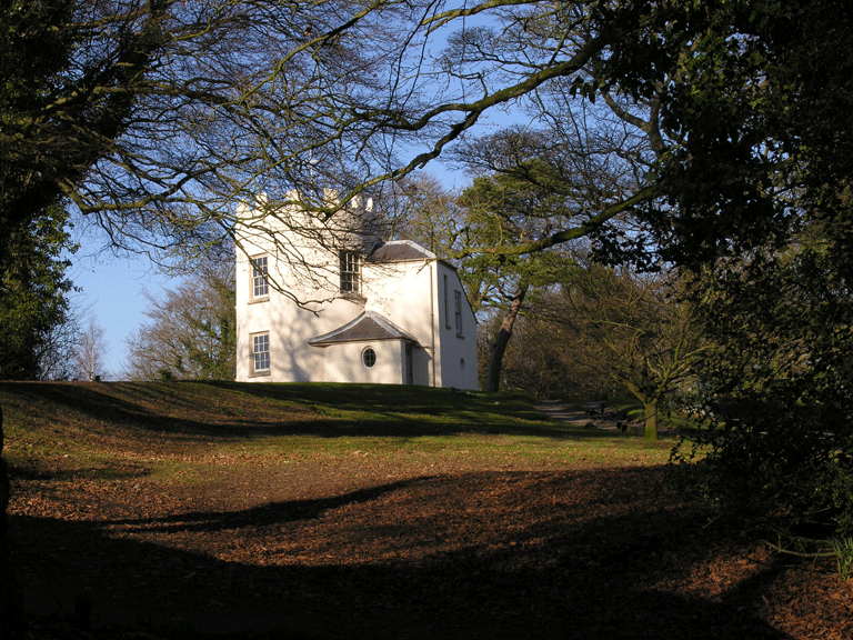
The known history of the area dates to the late eighteenth century, when the influence of the picturesque movement, particularly important in the Wye Valley, led to the appreciation of the views from the summit of the Kymin hill, and to the popularity of the area with local people. The Monmouth Picnic Club, led by Philip Meakins Hardwick, built the Round House in 1794 as a picnic house for its members, with a kitchen on the ground floor and dining room above, with five windows to take advantage of the spectacular views west into Wales towards the mountains around Abergavenny.
Subsequently, the Naval Temple was built, in 1800, commemorating the naval victories of the French Revolutionary Wars, and was dedicated on the second anniversary of Nelson's victory at the Battle of the Nile, by the Duchess of Beaufort, daughter of Admiral Boscawen, who was one of the Admirals commemorated by the temple. During a visit to Monmouth in 1802, Lord Nelson and Lady Hamilton visited the Naval Temple and the Round House.
The area continued to be used as a leisure facility through the nineteenth century, the bowling green, which was laid out around the time of the construction of the Round House, being used for other sports, including hockey. It was used as a showground, and in any major celebrations in Monmouth, particularly in 1905, the centenary of the Battle of Trafalgar (Register of Parks and Gardens Gwent 1994, 63). This use of the area continues up to the present, with the Kymin Dash, an annual race, which follows a course up the Kymin hill and through the park.
In 1902 Monmouthshire County Council gave the Round House to the National Trust, who restored it to its original appearance.
Historic Landscape Characteristics
Kymin Naval Temple is characterised by the recreational use of the land, inspired by the picturesque movement. The two main structures, the Kymin Round House and Naval Temple along with their associated features and surrounding gardens, particularly the walks through the woodland to the viewpoint, define the recreational character of the area. The Kymin Round House (PRN 03913g, NPRN 23097, LB 2222), a Grade II* Listed Building and prominent landmark, comprises a two-storey rendered and painted tower with a flat roof, from where the members of the Picnic club could view the surrounding landscape.
The picturesque and recreational character of the area is further highlighted by the walks, still popular today, which were cut through the woods at the crest of the hill and lead to a viewing point from which the view west across the Wye Valley is spectacular. The recreational and leisure uses of the area are also demonstrated by the large area of lawn laid out on the summit of the hill, originally a bowling green, the retaining wall of which is also protected as a Grade II Listed Building (LB 58228). This lawn was later used for other sporting activities, including hockey in the 1860s (Register of Parks and Gardens Gwent 1994, 63). The now listed Naval Temple (PRN 03912g, NPRN 32877, LB 2221 Grade II) is an important element relating to the recreational character of the area; this was constructed in 1800 to commemorate the admirals who had won naval victories during the Napoleonic wars. This building consists of memorial structure with two columned porticos and plaques listing the names of the admirals commemorated along with their naval victories, surmounted by a statue of Britannia.
The area has important historical associations, both with individuals and events: the area is closely associated with the picturesque movement of the latter part of the eighteenth century, to which it owes its popularity, and the structures built from the end of the eighteenth century provided views of the surrounding landscape and enhanced this aspect. Secondly, the commemorative naval temple is associated not only with the Beaufort family, but also with the naval victories, and the admirals it commemorates, most importantly, Lord Nelson, who visited the park in August 1802 (Bradney 1904, 23).
Ancient Woodland enhances the character of the area; the area is heavily wooded with mixed deciduous trees, while the associated picturesque walks to the viewing platforms run through the adjoining area of ancient woodland (part of Highmeadow Woods HLCA 019) specifically the area known as 'Beaulieu Woods'.
Communication is also an important factor in defining the characteristics of this area; apart from the network of minor winding lanes and paths connecting the area to the settlement below, the main communication feature within the area is the upper terminus of the public road, the Kymin Road at the National Trust Car park; this was the 'fine carriage road' commissioned by the Duchess of Beaufort in c. 1800, to provide access to the Naval Temple and the adjacent Round House. The area also contains tracks or footpaths (public rights of way) and includes a short section of the Offa's Dyke long distance path.
A further potential characteristic is that of defence in the form of a possible prehistoric hillfort on Kymin hill. The exact nature and location of this feature, which might extend into the neighbouring character area (The Kymin HLCA 006), is however, uncertain and requires further confirmation.