Lower Wye Valley
003 Chepstow
HLCA 003 Chepstow
Historic settlement core: Medieval walled town and early post-medieval extra-mural settlement: nucleated regular and organic (ie linear and irregular cluster); Post-medieval urban domestic, commercial, and civic buildings (medieval structures?); relict Anglo-Norman and medieval defensive; Medieval and Post-medieval ecclesiastic buildings (various); historic associations; communication features. Back to map
Historic Background
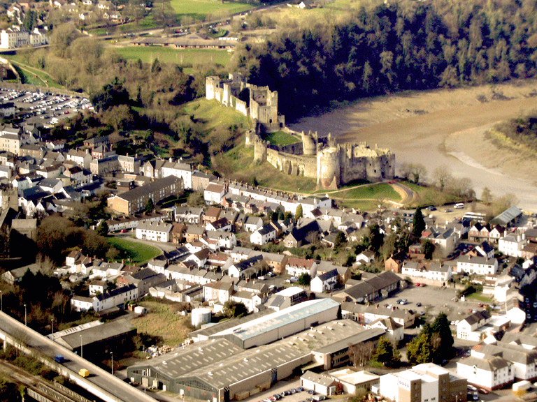
The historic landscape area of Chepstow is located at a bend in the River Wye close to the confluence of the Wye with the River Severn. The Wye here flows in a semi-circular route around the town and castle of Chepstow. The town and castle occupy a strategically important location, both in terms of visual prominence in the landscape and in terms of defence; the castle dominates the river frontage to the north and east of Chepstow.
There is little indication of prehistoric settlement in the immediate environs of the present town. However a Dobunnian gold stater was found close to the castle in the nineteenth century; a number of hillforts (Bulwarks, Piercefield and Llancaut) are in close proximity to the town. The main Roman road from Caerwent to Gloucester is supposed to have crossed the River Wye by a timber bridge some 1km north of the castle (a short length of agger has been identified near the river at Piercefield) and a number of Roman artefacts have been found by chance in the town, though outside of the characterisation area, and excavations have also found some ditches, three cremation burials and possibly the foundations of a timber shrine (Shoesmith 1991, 28) while re-used Roman tile is found in the Great Tower of the Chepstow castle (Perks 1967).
Estates in the region surrounding Chepstow are recorded in the Llandaff Charters, but none appear to refer to the present town area. It has been suggested that the area of the High Street may contain elements of a pre-Norman layout (Courtney 1995) although no direct evidence supporting this hypothesis has been found so far.
The medieval town of Chepstow developed around the castle, initially constructed between 1067 and 1071 by William fitz Osbern, who during the period also founded the Benedictine priory (now St Mary's Church), as a cell of the Abbey of Cormeilles in Normandy (now Chepstow's twin town). Initially, the priory would have had two or three monks, only later on acquiring conventual status with twelve monks and a prior in residence (Cathcart-King 1986). The priory church incorporated the parish church in its nave. It is assumed that a settlement (if one did not already exist) was established near the priory, though its exact location and layout is disputed. It is possible that may have been focused on a road partly following the line of Upper Church Street. This road would have connected the priory with the original entrance to the castle. If this were the case, then Hocker Hill Street, St Mary Street, Nelson Street and Church Street (all of which are at a right angle to Upper Church Street) would have formed a small grid system of streets (Shoesmith 1991, 161). Whatever the exact form of the new town, it expanded rapidly, as it is recorded in the Doomsday Book (1075) as being worth £16. Banks and ditches may have defended this small settlement, but no physical evidence for these features has so far been discovered. After the suppression of the priory in 1536 the church suffered much destruction, but the grandeur of the early Norman great church can still be seen today in the vast three-storey original nave.
In 1074 the castle and town were forfeited to the Crown after Roger, William fitz Osbern's son, was involved in an unsuccessful attempt to depose William the Conqueror, and remained in the hands of the Crown until AD 1115, when the Lordship of Striguil (ie Chepstow) was granted to Gilbert de Clare. The lordship passed to William Marshall in AD 1175, who carried out extensive building works at Chepstow Castle, adding the twin-towered great gatehouse, and new masonry defences to the baileys (Turner 2006). During the Marshalls' control, the town expanded and became wealthy through commercial enterprise and trade as a busy port. Following the death of Walter Marshall, in AD 1248, the lordship passed by marriage to the Bigod family, who added the lower bailey to the castle and were probably responsible for the construction of the town wall, known locally as the Port Wall (PRN 01186g, NPRN 302128, LB 2477, SAM MM002) (Perks 1967) that provided landward defences for the expanding town, enclosing some 53 hectares. The town was very prosperous as a regional market and mercantile port trading with the continent throughout the medieval period. This is reflected in the large number of burgages in the town; some 308 burgages were recorded by the year 1306 (Soulsby 1983, 107).
The Glyndwr rebellion does not appear to have directly affected the town, unlike most of the other settlements in Monmouthshire; similarly, the Black Death appears to have had little direct effect, although subsequent inflation and de-population of the fourteenth and fifteenth centuries will have indirectly influenced the town's prosperity.
The post-medieval town appears to have remained at a relatively similar size to the medieval one, thought there are some contemporary references that indicate some decline in population within the town, a charter of 1524 describing the town as having 'fallen into great ruin, indigence and decay' (Shoesmith 2006, 209). Of the medieval town, High Street, leading from the Town Gate and its continuation Bridge Street, are considered original; the marked contraction of the borough noted above with the loss of St Anne's and St Ewan's chapels and the southern part of the town is described by Leland as having been given over to 'little meadows and gardens' (Soulsby 1983). Excavation has subsequently revealed evidence of medieval settlement in this area.
The Civil War saw the town held by the Royalists until 1645, when it was captured and became the seat of the Parliamentary Committee for Monmouthshire. In the Second Civil War, the Royalists, under Sir Nicholas Kemeys, recaptured the town and castle. Parliamentary forces then besieged the castle, breached the walls and recaptured the castle. The castle's walls were subsequently rebuilt and the castle was used as a state prison until the end of the seventeenth century (Turner 2006).
The Millerd plan of the town dating to 1685 shows a street pattern which would be largely recognisable today, with a suburb west of the town gate, though with the southern part of the defended area enclosed by the Port Wall being used as fields and orchards. Morrice's map of 1800 shows little change had occurred in the intervening period in the layout of the town. The whole area east of the church and south of Back Lane was given over to agricultural use. It was only with the construction of the railway and growth in industrial and maritime activity experienced from the mid-nineteenth century that the southern part of the town came back into urban use (Soulsby 1983).
During the twentieth and twenty-first centuries the town expanded with the construction of various housing estates, to extend beyond the Port Wall and the limits of the current character area to the south, north and west; the progress of this development is charted by recent historic mapping and aerial photographic material.
Historic Landscape Characteristics
Chepstow is characterised as a medieval walled town and associated medieval castle. The main characteristic settlement comprises a mix of linear development along High Street, Bridge Street and Upper Street with linear burgage plots in evidence and a more irregular cluster in the area around St Mary's Church, the Benedictine priory church; the historic core of the town is bounded to the west by the Port Wall (PRN 01186g, NPRN 302128, LB 2477, SAM MM002). Much of today's urban settlement comprises post-medieval and potentially earlier medieval buildings masked by superimposed eighteenth and nineteenth century facades. The narrow street frontages of properties mirror the width of the linear burgage plots. The principal building materials used here in the earlier structures were both random and coursed stone, whereas the more modern structures were principally characterised by brick and concrete. The principal roofing materials throughout the settlement of Chepstow (HLCA 003) are slate and pantile.
Along Bridge Street a variety of buildings characteristic to Chepstow can be seen, generally of late eighteenth century appearance; many of these buildings are pebble-dashed and have ashlar finish render, this practice being a somewhat typical feature of secular architecture of the town (Newman 2000). Another characteristic feature of buildings lining the west side of this street is the bow window.
The town museum built in 1796 (originally Gwy House), again pebble-dashed though this time coloured dark red, exhibits a fine example of eighteenth century urban architecture. The semi-circular porch with coupled Doric columns of Bath stone is almost certainly an imitation of Bonomi's design at Piercefield Park (Newman 2000).
Chepstow has retained much of the character of its medieval and post-medieval street plan despite modern development, with a regular layout apparently added to and to an extent superimposed on an earlier less regular road and street pattern, centred on St Mary's Church. The street layout consists of several almost parallel roads aligned southwest-northeast within the bounds of the Port Wall. High Street, the main thoroughfare begins at the main gate (PRN 02728g, NPRN 302128, LB 2476, SAM MM002) to the town at the southwest; a narrower parallel road, separated from the latter by commercial properties and Bank Square, lies just north: this is Bank Street (Back Street on the First Edition OS), which leads into Hocker Hill (Hawkers Hill on the First Edition OS), beyond Beaufort Square, from where High Street merges into St Mary Street with Middle Street to the north, angled up to the northeast end of Hocker Street at the upper end of Church Street (St Mary's Church to the southeast) as it joins Bridge Street, at Thomas Powis Almshouse and the site of St Ewen's Chapel and vicarage (OS First Edition). High Street is the commercial heart of Chepstow with stores and banks in evidence on the OS First Edition map, as well as hotels, eg Beaufort Arms Hotel, public houses and places of worship, eg Ebenezer Chapel (Plymouth Brethren), and the Catholic Apostolic Chapel. St Mary Street also joins Church Street opposite Sir Walter Montague Almshouses (Old Almshouses on the OS First Edition). Further south are Upper Nelson Street, now partly taken by the course of the A48 bypass, and beyond Station Road, Lower Nelson Street, the latter joining Church Street at St Mary's Church. This route marks the traditional southern boundary of the medieval linear burgage plots fronting High Street; whilst to the south was an open area of enclosures (now developed for housing), largely orchards and nurseries. At the southern side of the junction of Upper and Lower Nelson and Station Road a Market is shown on the First Edition OS map opposite a hotel, and further to the south towards the station another school.
To the east of Church Street and southeast of Bridge Street, which leads northeast to the Bridge Inn and Chepstow Bridge, is an area which appears to be slightly less regularly laid out. This area contains Church Lane, Lower Church Street and St Anne's Street or Lane, and the two short passages known as 'the Back' leading to the old river side dock and slipway area, now the 'Promenade' (also known as 'the Back' on the OS First Edition); on this river frontage stood Custom House, Packet Slip and Lower Slip (OS First Edition). This area appears to be where much of the town's industrial activities were carried out; the OS First Edition map depicts a saw mill, a smithy, various saw pits, the gas works and gasometer, Bridge Works (Iron Founding and Engineering), and a bobbin factory all in this general area along with the workingmen's institute, Baptist chapel, infant school, post office and several public houses. Whilst, larger more affluent properties front Bridge Street, such as Guy House (now a museum) and what is now the Castle View Hotel, much of the building stock here appears to be of short rows of small cottages/industrial workers' style housing of eighteenth or nineteenth century date, including Howells Row and Church Row, as well as several terraces along Lower Church Street and on the south side of St Anne's Street.
Beyond the Port Wall and the town gate, Moor Street extends straight to the west, paralleled by Thomas Street, whilst to the west the street pattern splays out: Mounton Street heading northwest and Steep Street southwest. Welsh Street (the B1493), heads north just beyond the town gate via Cross Way Green (near the now developed site of the former St Kingsmark priory) and Piercefield beyond to St Arvan's. This extramural settlement, potentially of medieval origin, is certainly at least of early post-medieval date, and is characterised largely by ribbon development. This area contains chapels (Independent Chapel, Methodist Chapel, St Mary's RC Chapel, Bible Christian Chapel, shown on the OS First Edition), the site of the former Chepstow Work House (OS First Edition), a school (boys and girls), several large early nineteenth century town houses/villas (eg Huntfield House and its associated cottages), and hotels (George Hotel and Horn Hotel shown on the OS First Edition). The larger properties front the main streets with linear plots behind, as expected, in addition short rows of cottages, workers' houses are visible within a number of the rear plots on the OS First Edition, such as Mitre Court; these are located at a tangent to the main streets extending towards the rear of the plot. Some of these dwellings had only small yards to the rear, whilst others were without any outside space altogether. Most, if not all, have now been cleared.
Chepstow has a strong military aspect; the main element to survive in a recognisable form from the medieval period is the Anglo-Norman castle (PRN 01173g, NPRN 95237, LB 2475, MM003). The present castle appears to have been built initially as the centre of the marcher lordship of Chepstow (Striguil); a substantial stone built structure Chepstow Castle dominates the surrounding landscape. It is possible, given the commanding defensive location, that the site may have had a prehistoric or early medieval precursor. Chepstow Castle sits on the edge of the cliff overlooking the river, commanding the town, its important bridgehead, and controlling access up the lower reaches of the Wye. The defensive aspect of the castle continued beyond the medieval period into the troubled period of Civil War when it played a key role as a stronghold, variously held by Royalist and Parliamentarian forces (Turner 2006), and later was the location of a Home Guard store and training area during the Second World War (Defence of Britain Project CBA 2002, reference number 13580).
Chepstow's ecclesiastical remains are an important characteristic, ranging from relict archaeological features to standing buildings. The character area includes a number of churches and chapels such as the priory and later parish church of St Mary's (PRNs 01184g, 01183g; and NPRN 221448) with its associated churchyard (PRN 08154g). Supposedly of post-Norman foundation, though possibly on the site of an early medieval Welsh 'clas' site, the priory of St Mary's is first mentioned in the recorded in 1071 as a daughter house of the Benedictine abbey of Cormeilles (Evans 2004). The original priory building, constructed mainly of yellow Triassic sandstone, has been much altered from its cruciform medieval plan; extensive demolition and rebuilding works were carried out after the Dissolution in 1536, particularly during the eighteenth and nineteenth centuries. The surviving remnants of the Norman priory include an archway and parts of the nave. The overall surviving structure is a curious mixture of Romanesque and Gothic elements and reflects later eighteenth and nineteenth century alterations. The churchyard associated with St Mary's is irregular in plan, and has appeared as such since at least the mapping of the tithe in 1846. Despite some recent clearance of monuments and the addition of a wider entrance for cars to the south, the churchyard maintains its ecclesiastical character, which includes its enclosing boundary.
Other ecclesiastical features in the area from the medieval period include the site of the now destroyed Chapel of St Anne (PRN 01174g), additionally, St Ewin's or Owens Chapel (PRN 01176g), St Thomas' Chapel (PRN 01189g), and the holy wells near Bridge Street (PRN 01175g). Reference to a cross of unknown date, 'Robin Hoods Cross' (PRN 01188g), might in fact relate to communications rather than to an ecclesiastic feature. Later ecclesiastical sites are mostly post-medieval Nonconformist and other chapels, these include: Chepstow Wesleyan Methodist Church (NPRN 105516, LB20751 Grade II), built 1855 in the Gothic style to designs by James Wilson of Bath; Lower Church Street Baptist Church (NPRN 10513), a Romanesque and Lombardic/Italian style church built 1816; and the High Street Bible Christian Chapel (NPRN 307556) with its half-hipped roof design, the latter now incorporated into a range of flanking buildings.
Characteristic communication routes are the medieval street pattern described above, depicted on historic maps such as the tithe map of 1846 and subsequent OS maps. Several footpaths also cross the area, two of these are the Wye Valley Walk, managed by the Wye Valley AONB and the Forestry Commission, and the Offa's Dyke Path, a National Trail route, which loop through the area talking the walker past Chepstow Castle.
The associated Chepstow Town slipway (PRN 05478g, NPRN 401823, SAM MM301) straddles the boundary of the character area with HLCA 001 to the east.