Lower Wye Valley
022 Cuckoo Wood
HLCA 022 Cuckoo Wood
Ancient Woodland with isolated post-medieval encroachment of smallholdings and walled enclosures: relict industrial archaeology: quarrying; traditional boundaries (dry-stone walls) and other boundary features (eg 'The Resting Stone'); communication features. Back to map
Historic Background
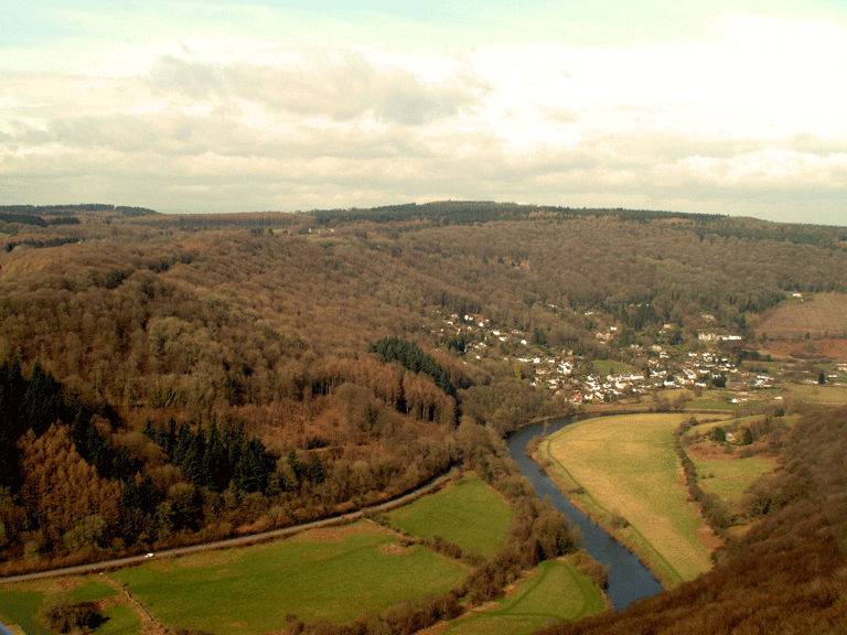
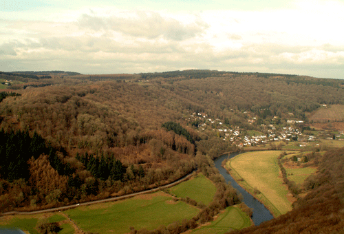
The historic landscape area of Cuckoo Wood exists as ancient woodland occupying the steeply sloping west valley side between Tintern Parva in the south, and Pilstone in the north. Its boundaries are defined by the extent of the ancient woodland, and the area historically fell within the parish of Llandogo, part of which was a manor of the See of Llandaff, the remainder of the parish was part of the manor of Trellech. The majority of the land within the area belonged to the Beaufort estate. Along with the adjoining village of Llandogo, parts of the area of ancient woodland are designated and protected as Conservation Area 1 by Monmouthshire County Council in the 2006 Adopted Unitary Development Plan.
The area has existed as ancient woodland throughout much of its history, and much of it has survived as semi-natural woodland of native deciduous types, rather than as replanted woodland where conifers have been planted relatively recently (normally within the last 200 years) to replace cleared broadleaf trees.
Early medieval historical associations link the area to 'Buddig' the father of St Oudoceus, to whom the church at Llandogo is dedicated. The modern name of the area of woodland to the south is 'Coed Beddick', a corruption of 'Buddig' (Bradney 1913).
There is little evidence for occupation or activity in the area before the medieval period, while medieval evidence is limited to documentary references to an area of Welsh tenure known as 'Caletan' (Rees 1932, SE Sheet), mentioned in the Book of Llandaff as defining the extent of a grant of land and forming a boundary of Llandogo (Bradney 1913, 206). Although the exact location is unclear, it survives in the place-name Cleddon, an area of settlement just to the west of the woodland.
The majority of the settlement activity in the area dates probably to the post-medieval period, a number of enclosures and isolated cottages are in existence from at least the First Edition OS map (1879/1881) and the majority are depicted on the tithe map (1844). This lists the substantial areas of the woodland as belonging to the Beaufort estate, with the small enclosures let to various smallholders, being used mainly as arable land.
Further post-medieval activity in the area shows the importance of communication routes through the woodland; as well as a milestone on the road running north through the woodland to Llandogo, there is also a direction marker at a fork in the road south to Tintern Parva from Cleddon, and a resting stone on the path from Cleddon to Llandogo.
Modern activity in the area is limited; overall, it is very little changed from the tithe map (1844). A Second World War pillbox overlooks the fields of Pilstone Farm and the River Wye (NPRN 270429).
Historic Landscape Characteristics
Cuckoo Wood is characterised by ancient woodland, both semi-natural and replanted, which forms a long stretch of the west side of the Wye Valley which consists mainly of mixed broadleaf type, with small patches of evergreens. A small area near Llandogo is protected as a SSSI, Cleddon Shoots Wood, which consists mainly of oak and beech, with ash and alder along the stream.
The settlement of the area is characterised by isolated smallholdings, several still occupied, and a scattering of small enclosures in isolated clearings, probably representing minor post-medieval encroachment into the woodland for agricultural purposes. These include areas of small to medium-sized irregular fields in the north and east of the area on the 1844 tithe (generally south of Pilstone and east of Llandogo) amalgamated into the woodland by 1881 (OS 1st edition), and a few isolated rectilinear enclosures of post-medieval date. Among these are three rectilinear enclosures known locally as 'The Gardens' (PRNs 07085g, 07086g, and 07087g), bounded by dry stonewalls. Additionally, there is a building platform (PRN 07164g) with three associated enclosures and scattered boulders (07163g), which appear to be the remains of settlement. Also depicted is a further settlement associated with an area of irregular enclosure; this settlement contains a rectangular building (PRN 07482g), associated with a dwelling named as 'Bigsnap', which still stands (OS First Edition).
Historical associations are an additional feature, which contribute to the character of the area. The southern part of the woodland is named after 'Buddig' the father of St Oudoceus, (Bradney 1913) to whom the church at Llandogo is dedicated; the modern name, 'Coed Beddick', is a corruption of 'Buddig'. Nearby just to the west outside the boundaries of the historic landscape, is Cleddon Hall in its woodland setting, the birthplace of Bertrand Russell (Born 1872). The latter also noted for its place-name associations with a form of medieval Welsh tenure, 'Caletan' (PRN 03911g).
Communication is represented by a milestone (PRN 07426g), a direction marker, protected as a grade II Listed Building (PRN 07949g, LB 24930), and a resting stone (PRN 00737g), extant in the seventeenth century and mentioned in a survey of Trellech manor dating to 1677. Modern communication links include the footpath of the Wye Valley walk, which runs from north to south through the woodland.
Extractive activity is an additional minor feature which adds to the character of the area, a quarry is depicted on the Second Edition OS map (1902) on the south edge of the area. A further secondary feature which adds to the character of the area is a Second World War pillbox, a rifle trench built of brick with a concrete roof, (NPRN 270429), which lies in the east of the area, on the slopes overlooking the south end of Pilstone Farm. A more recent addition to the character of the area is the leisure and tourism aspect, represented by the Botany Bay Camping and Activity Centre on the west side of the wooded ridge.