Lower Wye Valley
028 The Narth
HLCA 028 The Narth
Irregular post-medieval and 20th century settlement on the edge of Trellech Common: scatter of post-medieval farmsteads and cottages with recent dense, though irregular development of bungalows and houses; irregular evolved fieldscape of small irregular enclosures, minor amalgamation and subdivision for building plots; good 19th century vernacular buildings; mixed woodland; traditional boundaries; communication features. Back to map
Historic Background
The historic landscape area of The Narth is an area now partially dominated by recent sub-urban settlement. It occupies a clearing in the woodland on the summit of a hill overlooking both the Wye and Whitebrook Valleys. The boundary between the parishes of Llandogo and Trellech runs from north to south through the character area, the most significant landowner in the area was the Duke of Beaufort, with a scattering of parcels of land owned by other individuals. The Duke was the Lord of the Manor of Trellech, which included the parts of the parish Llandogo, which did not fall within the manor of Llandogo. The lord of this manor was the Bishop of Llandaff (Bradney 1913, 136). The area is bounded by woodland on all sides, the ancient semi-natural woodland of the Wye Valley to the south, and the ancient replanted woodland on the slopes of the Whitebrook Valley to the north and east.
There is no evidence for occupation of the area before the post-medieval period, and this area most likely represents an area of post-medieval forest clearance and encroachment; the landscape is significantly altered during the nineteenth century. The greater part of the area lies within the parish of Trellech, most of which was unenclosed until 1810, when an Act was passed to enclose the land both in the parish of Trellech and in several neighbouring parishes (Penallt, Mitchel-Troy, Cwmcarvan, Llandogo, Tintern, and Llanishen). This process of enclosure and encroachments in the part of The Narth, which falls within Trellech, can be traced on the historic maps of the area. The tithe map (1845) depicts a small patch of enclosures, close to the boundary with Llandogo parish, which are clustered along roads and around crossroads, which form the nucleus of the modern area, while the remainder, around the perimeter is still unenclosed. The fields, which are depicted in the tithe map, are generally small, irregular and curvilinear, radiating out from the junctions of lanes, which form the nucleus of the area. This process of enclosure has been completed by the date of the First Edition OS (1881).
This pattern of enclosure and settlement remains almost unaltered at least until the Third Edition OS (1921). During the latter part of the twentieth century much of the area is developed for housing, with infilling and estate construction. The twentieth century buildings now dominate the older nineteenth century cottages and post-medieval farmhouses, formerly associated with the agricultural enclosure of the area.
Historic Landscape Characteristics
The Narth is characterised as a post-medieval agricultural landscape with a scatter of small-scale nineteenth century cottages and very small farms (or small-holdings), augmented by twentieth century development. The area is typical of forest clearance or encroachment, and the settlement development appears haphazard with very individual housing style, and no particular uniformity. The twentieth century development is suburban in character.
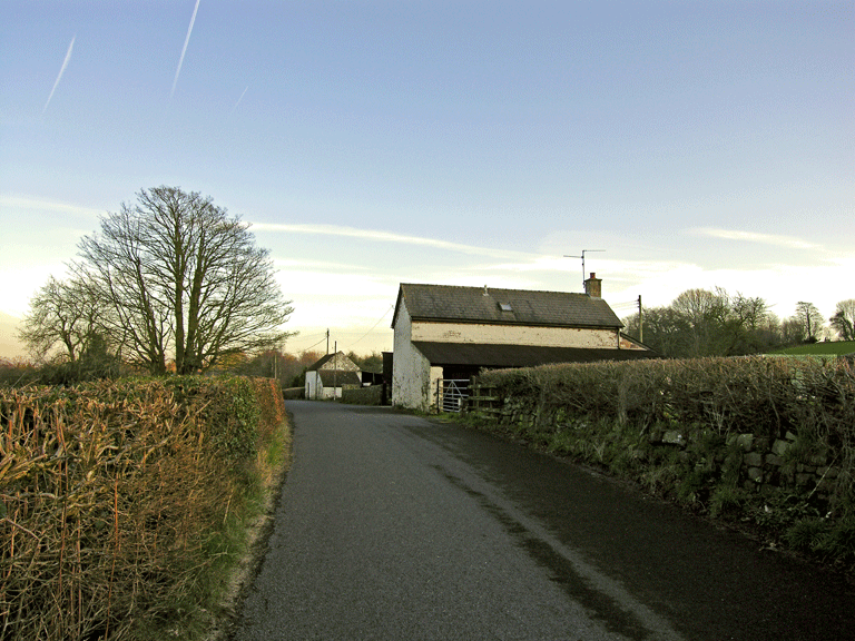
There is a scatter of older buildings, mainly nineteenth century cottages and farm buildings, depicted on tithe maps (1844/1845); constructed of painted or rendered stone with slate roofs. A particular example is the barn at Rose Farm, extant on the tithe map (1845) which sits gable-end on to the road, and Yew Tree Cottage, a nineteenth century cottage displaying the distinctive vernacular character. The farms are very small, and appear entirely unchanged in layout from historic mapping; they consist of the farmhouse, usually with no more than a single small associated farm building. Interestingly, the current 'Narth Farm', although shown on both the tithe and First Edition OS maps, is unnamed, while the complex depicted as 'Narth Farm' on the First Edition OS (1881) is now known as 'Old Narth Farm', indicating a shift in agricultural emphasis.
The more recent houses contribute a decidedly suburban character to the area; these include individual houses and bungalows in their own grounds, as well as a small council (or possibly forestry commission) estate. These houses appear to have been superimposed in piecemeal fashion on the irregular enclosure landscape and are perhaps indicative of individual development rather than a single phase of planned construction or development. Little effective visible regulation or planning control appears to have obviously influenced the nature of the recent settlement expansion, apart from the case of the small estate. Although there is no one particular style, the buildings are generally detached houses or bungalows standing in their own grounds, mainly constructed of brick or are rendered, with pantile roofs. Further study of the settlement development is required to establish whether there was an intermediate stage of holiday cabins to account for this strange growth pattern.
The agricultural fieldscape in the area generally comprises small enclosures of varied irregular pattern, from initial curvilinear encroachments to later more regular intake along the western edge of the area, where it bounds Trelleck Common. The evolved, irregular field system as it currently exists is relatively unaltered from the First Edition OS, although there has some amalgamation in the west of the area between the mid and later nineteenth century. The agriculture is currently under a mixed regime of arable and grass, largely unchanged to that given in the tithe apportionment. The fields are bounded by low earth banks topped with hedges, and by dry-stone walls, although distinctive mature trees also survive in the boundaries, suggesting that the land was originally won from the surrounding woodland.
The area, bounded by woodland on all sides, is likely to have been won through encroachment into woodland, and trees are a surviving characteristic of the area, both as discrete stands and in field boundaries. Ancient replanted woodland of mixed deciduous and evergreen types forms the boundary to the north and east where it covers the steep slopes on the south side of the Whitebrook Valley. The south side is bounded by ancient semi-natural woodland of deciduous and other broadleaf types, while the remaining west boundary is formed by the edge of the plantation on Trelleck Common.
The communication routes in the area are largely winding lanes, and public rights of way; these connect the dispersed cottages and smallholdings and the later settlement cluster. The winding lanes appear to respect and mirror the curvilinear encroachment boundaries, and may define various phases of encroachment. A bus route, which serves the modern settlement, emphasises the residential suburban aspect of the area's more recent settlement.