Lower Wye Valley
024 Llandogo
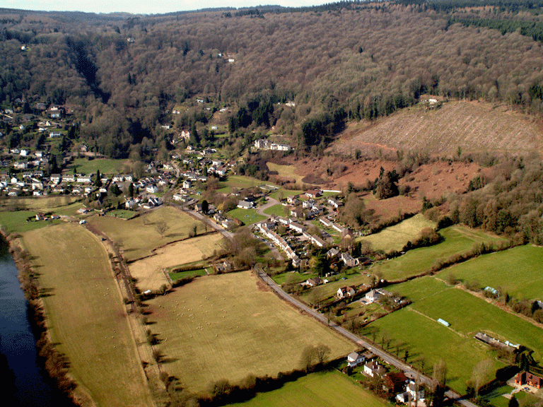
HLCA 024 Llandogo
Medieval/Post-medieval settlement with early medieval origins and associated agricultural hinterland: settlement pattern: nucleated cluster around church; ribbon development and irregular cluster on slope; typical 19th/20th century settlement features/building types; ecclesiastical: medieval/post medieval church and cemetery (early medieval origins); post-medieval chapel; traditional boundaries; varied irregular enclosure/field pattern: small wooded (orchards?) enclosures associated with settlement, medium to large irregular fields around Rectory; Communication features. Back to map
Historic Background
The historic landscape area of Llandogo is an area of settlement with an interesting early ecclesiastical history. It is the main village of the parish of Llandogo, part of which was a manor of the See of Llandaff, the remainder falling in the manor of Trellech, held by the Duke of Beaufort. By the date of the tithe map (1844) the principal landowner was the Duke of Beaufort. It occupies the lower slopes of the hillside at a sharp bend in the River Wye, and sits below the wooded upper slopes. The bowl-shaped area is enclosed by the steep hillside and is bounded by ancient woodland to the north, south and west, while the line of the modern transport corridor run along the riverbank to the east. The areas of settlement at Llandogo, as well as parts of the adjoining ancient woodland are designated and protected as Conservation Area 1 by Monmouthshire County Council (Adopted Unitary Development Plan. 2006).
The development of the settlement at Llandogo has been dictated by its early ecclesiastical history. The early medieval origins of the village are demonstrated by the dedication of the church to St Oudoceus, the third Bishop of Llandaff, who lived in the sixth century. A story related in the Life of St Oudoceus tells that he 'served God on the brook Caletan' (the modern Cleddon Brook) and that King Einion of Glewyssig was hunting a stag on the River Wye, and that the stag escaped the hounds by lying on St Oudoceus' cloak. The king then gave the area to the See of Llandaff, and Oudoceus built a house and oratory there (Bradney 1913, 206).
The area was an important early medieval monastic site, a manor of the See of Llandaff and is mentioned several times in the Llandaff Charters between the early seventh century and the mid-tenth century, (c625 and c698) the latter recording the boundaries of the manor granted to the Bishop by King Morgan of Glewyssig, and lastly, in c942 calling a synod there. It is possible that the bishopric of Welsh Bicknor was moved to Llandogo around 900, before moving again to Llandaff (Davies 1978 158). Physical evidence in the form of the original curvilinear churchyard on early maps (tithe map) supports other documentary evidence for an early medieval ecclesiastical origin.
A description of the heavily altered medieval church (PRN 00741g) survives from 1849; it comprised a medieval chancel with single trefoil-headed lancets on the north and southeast, an altered nave, while the chancel arch, north aisle and colonnade were all later additions (Glynne 1902, 90).
The architect John Pollard Seddon, surveyor to the Archdeaconry of Monmouth and consulting architect to the Incorporated Church Building Society, was responsible for the reconstruction of the original church between 1859 and 1861. The new church (PRN 07881g, LB 18575 Grade II*) was apparently built on new foundations removing all trace of the medieval building, apart from monuments in the south porch. Seddon and Coates Carter, with whom Seddon was in partnership between 1885 and 1904, carried out further work in 1889. At this time, the south porch and vestry were added and the decorative scheme for the chancel, including the reredos by Clarke of Llandaff and the mosaics by Powell of London was executed. A German artist painted the walls to the designs of Coates Carter.
The tithe map shows the settlement of the village of Llandogo as three distinct groups of housing, probably relating to phases in the development of the settlement. The earliest phase would appear to be represented by the medieval settlement associated and nucleated around the church, while later phases are represented by post-medieval settlement expansion up the hillside, and ribbon development along the Turnpike Road of 1829 and the banks of the River Wye, as shown on the early editions of OS maps (1881, 1902, and 1921). 'The Falls', also known as 'The Priory', was the principal house of the area shown on the Tithe; this was built for John Gough in 1838 by the architects Wyatt and Brandon (Newman 2000, 275). Although the majority of the land in the parish of Llandogo belonged to the Beaufort estate, the Gough family owned most of the village of Llandogo itself. The tithe map of 1844 lists one Eliza Gough as the owner of most of the land in Llandogo. The Gough family operated river barges (sloops or trows) on the Wye, and it is likely that the construction of the railway severely affected their business.
The river was an important communication and transport route through the area, prior to the construction of the turnpike road, and the profit from these businesses was important in the history of the area, particularly for the Gough family.
It is likely that with the construction of the Turnpike Road from Monmouth to Chepstow, through the area between 1826 and 1830, further settlement occurred, especially along the route of the Turnpike, the A466 Road. As well as further opening up the communications of the area, the construction of the Wye Valley Railway in 1876 with a station Llandogo Halt would also have had a direct impact on the growth of Llandogo.
Apart from additional infilling of the ribbon development along the A466, recent housing estates built to the west and northwest of the church, have increased the size of the village.
Historic Landscape Characteristics
Llandogo is characterised as a largely post-medieval settlement with early medieval/medieval origins. Llandogo has a characteristic scatter of cottages interspersed with modern building on the upper slopes and some early twentieth century picturesque buildings. The medieval church was completely rebuilt 1859-61, giving some indication, perhaps, of settlement growth in the first half of the nineteenth century. Llandogo has a range of types and scales of houses, including some which have definite Georgian classical aspirations, and also a row of possible back-to-back cottages. Typical buildings in the character area noted from historic mapping, in addition to cottages and a single farmhouse, include terraced housing, shops, post office, hotel, school (boys and girls), places of worship (Chapel and church) and a pound (OS 1st edition). No planning is evident in the settlement layout with building alignments typically random. The area above the village displays a scatter of early nineteenth century small-scale cottages. The buildings are predominantly constructed of rendered stone, with slate roofs, but modern development has led to greater diversity of materials and variations in style. Lower down the slopes, The Old Farmhouse may be slightly earlier in origin. There has also been later estate building on terrace above river, including a council development of c1950 (vernacular revival). The area has numerous bungalows.
The initial settlement of Llandogo is likely to have developed following the establishment of an early monastic centre here, the oratory of St Oudoceus (PRN 00705g), the focal point of a pre-Norman ecclesiastical Manor. By the mid-nineteenth century the area had developed as several distinct settlement areas (tithe map of 1844): the medieval core in the vicinity of the church; two areas of eighteenth and early nineteenth century settlement expansion up the hill encroaching into the surrounding woodland, primarily represented by cottages or small farmsteads (smallholdings) within a matrix of irregular evolved enclosure; and a loose linear ribbon development of dispersed properties, including a post office and smithy along the road and river bank leading to the south. These settlement areas remain visible elements to this day, despite additional nineteenth and twentieth century infilling along the A466.
The early nineteenth century picturesque theme is evinced in villas and cottages ornee, such as the impressive Llandogo Priory (NPRN 45,071), a substantial gabled and barge boarded villa built in 1838 by the architects Wyatt and Brandon for the Gough family. Located in a prominent position, the house is constructed of the local mauve sandstone, and has a recessed centre with two-storey timber veranda between symmetrical gables, an oriel window beneath the right gable (Newman 200, 275). Associated are contemporary gardens (NPRN 308,476) and the lodge to the Priory, a Grade II Listed Building (PRN 07948g; LB 24931); built in the mid-nineteenth century and later extended, it is constructed of red sandstone rubble with some ashlar dressings.
The area has important ecclesiastical associations; originally a monastic site and later a prebend, Llandogo was a manor of the See of Llandaff and is first mentioned in c625 in the Llandaff charters. Further references dating from c625 to 942 indicate the importance of the site (Brook 1988 72-73 79). The church at Llandogo is dedicated to St Oudoceus (Docheu or Dochwy), the third bishop of Llandaff, who is said to have built a house and oratory (PRN 00705g) in the area during the sixth century. The dedication to St Oudoceus, the historical references in the Llandaff Charters, and the partly curvilinear churchyard (PRN 07944g, LB 24919) depicted on the tithe map (1844) indicate a pre-Norman date for the founding of the original church. The church, and a large area, which extends beyond the boundaries of the parish of Llandogo, is later mentioned in the Charters as being granted to the see of Llandaff by King Morgan of Glewyssing.
The church (PRN 07881g, LB 18575 Grade II*), re-built between 1859 and 1861 by John Pollard Seddon and Coates Carter, is constructed in roughly-coursed, squared red sandstone blocks, with dressings and architectural detail mainly in Bath stone but with sandstone used in places to create a striped effect with a Welsh slate roof. Its churchyard (PRN 08177g) setting is now polygonal in shape but on both the tithe map (1844) and the First Edition OS (1881) it is partially curvilinear. The churchyard wall (PRN 07944g, LB 24919 grade II) is constructed of roughly coursed sandstone and conglomerate rubble, broken by two gates and a stile. It stands between one and one-and-a-half metres high, and is topped with rounded coping of small stones. It appears to predate the present church building, possibly of seventeenth century in date, and is considered to demarcate the extent of the original medieval churchyard. The tombs in the churchyard add to the ecclesiastical character of the area, two groups of chest tombs constructed of sandstone (PRNs 07945g, 07946g) date from before the rebuilding of the original church, the earliest dating to 1736.
An important characteristic within the area are communication routes which range from the network of characteristically narrow and steep winding lanes of the precipitous hillsides to the main valley bottom route of the A466 Road, the route of the Turnpike Road of 1829. Within the hillside and older settlement areas the network of narrow enclosed winding lanes (the majority now statutory rights of way) provides access to the various holdings and cottages; massively constructed drystone walls, including quarried conglomerate slabs, enclose many of these lanes. Prior to the construction of the Turnpike Road, the main routes to Llandogo were the minor lane from Tintern, which contours the hillside from the south above the main road, and another very steep lane, which passes above the 'Priory' via Cleddon en route to Trellech. Other lanes provide access to the church and to the River Wye and the wharf area. These routes and other minor paths are likely to have their origins in the medieval period, if not earlier. The River Wye, itself, was an important communication and transport route prior to the construction of the turnpike road in the nineteenth century, and river traffic was important to the economy of the area, with barges, known as sloops or trows transporting goods up the valley. This river transportation is echoed in place names, such as The Ship Inn and Trow Cottage.
Agriculture, now marginal and confined to the northern part of the character area, provides a further characteristic. The cohesion of area's field pattern of medium-sized, though irregular fields, recognisable from the tithe map, was first disrupted by the construction of the Wye Valley Railway (First Edition OS), and later by twentieth century sub-urban development. The remaining agricultural areas are primarily meadow and pasture land; wooded enclosures, and orchards are also in evidence.