Lower Wye Valley
027 Hael Woods
HLCA 027 Hael Woods
Ancient Woodland with dispersed wooded irregular encroachment and scattered (ribbon development) post-medieval? settlement (the Birches): industrial archaeology: metal processing (early Whitebrook wireworks site); quarrying (including millstones); limekilns; cider presses/mills; water management: leats, reservoir, dam (association with Whitebrook wireworks); historic associations; woodland management features; boundary features (boundary stones). Back to map
Historic Background
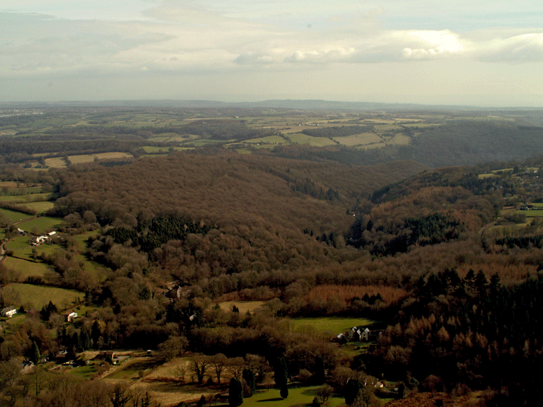
The historic landscape are of Hael Woods is ancient woodland on the slopes of the Wye Valley, the Whitebrook Valley, and the mouth of the Blackbrook Valley. The area includes Lower and Upper Hael Woods, Manor Woods, Pwllplythin Woods, Colonel's Park, Graig Wood, Young's Grove, Luggas Wood, Pwll Mawr Wood, Washing's Wood and Lower Wood, as well as the settlement of 'the Birches'. The area lies within the historic parishes of Penallt, Trellech and Llandogo, the main landowner in the area being the Duke of Beaufort. The boundaries of the area are defined by the extent of ancient woodland. Almost half of the area's ancient woodland is semi-natural ancient broad-leafed woodland in existence from at least 1600.
The earliest evidence for activity in the area is medieval, in the form of a quarry, which is believed to have provided the stone for the medieval Raglan Castle (Bradney 1896, 70-1). Further medieval occupation is attested by a reference in a lease dated 1594 to St Denis' Chapel, thought to be located near the mouth of the Black Brook valley.
A Grist Mill in the south of the area, near the mouth of the Whitebrook Valley, is the earliest example of industry. Subsequently, the Whitebrook Wireworks were established around 1600; a branch of The Lower or Abbey Wire/Ironworks, which were completed in 1567. As at Tintern, the Society of Mineral and Battery Works operated the Whitebrook Wireworks, until it closed around 1720 (Coates 1992, 25). The importance of industry to the area is clear from the number of associated features which lie within this area of woodland, most of which are linked to the industrial activities in the adjoining Whitebrook Valley (HLCA 029). The majority of these are water-management features; dams, reservoirs and leats, which supplied both the seventeenth century wireworks within the area and the later eighteenth century paper mills within the Whitebrook Valley; the paper industry here was started about 1760 (Coates 1992, 25). Two streams, which run through the woodlands of the area, provided the water supply necessary for manufacturing, and to power the machines: the White Brook and the Manor Brook.
The industrial history of the area is further represented by quarries, which supplied the corn and cider mills of the locality with millstones, the hard sandstone of the area with small quartz pebbles (known as Pudding Stone, Breccia or Jack Stone) being very suitable. The extractive areas contain numbers of unfinished stones; it seems that a high number were faulty or damaged before completion, and abandoned in situ. The local millstone industry ceased around 1875, following the large-scale import of wheat from North America, and the construction of the Wye Valley Railway.
Proximity to the potential site of the medieval Chapel of St Denis means it is likely that the settlement in the north of the area, around the mouth of the Black Brook Valley, may be medieval in origin. The tithe map (1847) depicted the settlement of the 'Birches', which had expanded by the time of the First Edition OS maps (1887) then remained relatively unchanged until the Third Edition (1922). Development since the 1920s has been limited.
Historic Landscape Characteristics
Hael Woods is characterised by ancient woodland, mainly of mixed native deciduous and other broadleaf types, with some coniferous patches. Two stretches of the woodland along the steep slopes overlooking the River Wye are designated Sites of Special Scientific Interest, Lower Hael Wood (818/33WGL) and Graig Wood, slightly further north (1,030/33WGE). Both these SSSIs fall within areas of semi-natural woodland as opposed to replanted woodland. Although there has been some encroachment into the woodland in the north of the area, around the mouth of the Black Brook Valley, with small enclosures associated with settlement and agriculture, the forestry remains dominant here; stands of trees survive between cleared enclosures, and form their boundaries.
There are significant industrial remains in the area, several of which are associated with the adjoining industrial area, the Whitebrook Valley (HLCA 029). A particularly important industrial site within this character area is that of the Whitebrook Wireworks (PRN 06255g, NPRN 276006, SAM MM 270). The remains consist of stonewalls belonging to ruined buildings, possibly dwellings, and a series of terraces in the steep hillside. There is strong potential for the survival of belowground features, as the site was abandoned after its closure. A number of features are associated with these wireworks; the most important being a leat (SAM MM 292), which feeds the works, and runs for over a kilometre from the White Brook (Coates 1992, 30). Another possible leat (PRN 07099g), which ran to these wireworks, survives as a tree-lined feature with a stone revetment wall.
Other industrial remains include a complex of water management features in the vicinity of Manor Brook associated with the mills in the Whitebrook Valley; these are a reservoir (PRN 07093g), its associated dam (PRN 07094g), shelter (PRN 07095g), and overflow leat (PRN 07096g). In addition, there is a further leat (PRN 08999.0g) on the other side of the Whitebrook Valley, probably also associated with the mills in the valley.
The area contains numerous small quarries, one of which is thought to be medieval date and to have been the source of old red sandstone used in the construction of Raglan Castle (PRN 00666g). Of the area other quarries (PRNs 04067g, 04068g, 04069g, 07432g, and 08996g), at least one of which is known to have produced millstones. Also of note is a possible limekiln (PRN 08998g), its structural remains associated with lime and iron forge slag.
In common with other areas in the Wye Valley, cider production is a characteristic feature of Hael Woods. This industry is represented by a cider press (PRN 07103g) in the south of the area, with an associated millstone some two metres in diameter. There are two other unfinished cider press stones in the locality, both partly cut from the sandstone conglomerate (PRNs 07108g, 07090g).
The area contains some evidence of settlement, and agriculture, particularly in the north of the area; settlement with associated enclosures, a dispersed linear ribbon development, is depicted on the tithe map of 1847 at the mouth of the Black Brook Valley, and further settlement growth can be traced on the First Edition OS maps (1887). It remains relatively unchanged thereafter.
The settlement of the area is essentially representative of early post-medieval, possibly earlier, encroachment, characterised by dispersed scattered smallholdings and cottages. The area, known as 'The Birches' has seen some limited recent settlement expansion, although the predominant building type remains cottages/small farmsteads, again largely dispersed set in small irregular enclosures cleared from the surrounding woodland. The First Edition OS depicts a number of cottages and small farmsteads (eg. Birches Farm, Cae Dee, Hillside, The Birches, Blaen Brook, and Glen View Cottage, Wye View) characteristically small single linear ranges. Good examples of vernacular building and nineteenth century cottages survive.
The pattern, extent and character of the current associated enclosure remains largely unchanged from that depicted on the First Edition OS map, essentially small-scale irregular enclosures with boundaries formed of hedges with distinctive mature hedgerow trees. The process of post-medieval encroachment is visibly demonstrated between the tithe and the First Edition OS with additional enclosure as well as additional holdings/dwellings in place by the survey of the latter. For instance neither of the holdings known as Barberry, and The Birches appears on the Tithe, though both are shown on the OS First Edition; the location of these holdings are depicted during the mid-nineteenth century as open unenclosed hillside with an un-fenced track way running through the area. At this date enclosure and encroachment in the area is still incomplete and fragmentary, with the curvilinear boundaries of individual closes and clustered encroachments easily distinguishable.
Though dispersed scattered settlement predominates, the tithe map and the OS First Edition does depict a small cluster at the higher ferry crossing (Upper Redbrook Passage on Tithe) to Redbrook and Whitehall, comprising the latter, the Wheatsheaf public house (now Upper Ferry House), Whitehall Cottage and several other dwellings or structures, no longer evident on current mapping. Further south, at the lower ferry crossing (Lower Redbrook Passage) to Lower Redbrook is a further settlement, this time a diminutive linear settlement with a few outlying cottages (including Wye View) following the lane to the west. The main element of the settlement is a row of workers' cottages (also on the Tithe, now Steps Cottage), possibly ferrymen's cottages, and the later Bridge Cottage and the Boat Inn at its northern end with its adjacent quarry (PRN 00666g), facing the Redbrook Railway Bridge (now a foot bridge), a viaduct built in 1876 by the Monmouth and Wye Valley Railway Company (PRN 03267.2g). The Boat Inn and Bridge Cottage are first depicted on the First Edition OS map and would appear to represent late nineteenth century settlement growth associated with the construction of the adjacent Wye Valley Railway, the adjacent quarry, and increased ferry traffic during the period.
An additional aspect, which contributes to the character of the area, is the potential ecclesiastical association. There are documentary references to a Chapel in the vicinity dedicated to St Denis; it is mentioned on a lease dated 1594. Although there are no extant remains or any specific sites known for this chapel, there is a field in the area known locally as 'Chapel Field', currently under pasture (Brook 1988, 82).
Communication routes are represented by several footpaths and bridleways in the south, and minor roads in the north, as well as sunken lanes bounded by high dry stonewalls. The Wye Valley Walk runs along the edge of the character area, on the bank of the river. There are also ancient tracks running through the area; (PRN 07101g) is part of a larger network; a packhorse track, (PRN 07089g) known locally as 'donkey track' may be associated with the nearby wireworks (PRN 06255g, NPRN 276006, SAM MM270) and is probably of seventeenth century date.
The place name Hael Woods might display a connection with the Gwentian figure Ifor Hael (Ifor ap Llywelyn of Gwernycleppa near Newport, fl. 1340-60). Ifor Hael and his family were known for their patronage of the foremost of Welsh poets of the medieval period, most famously Dafydd ap Gwilym. A nephew of Ifor Hael, Phylip ap Morgan, steward to the Mortimer Lordship of Usk and Caerleon, was credited with commissioning Iolo Goch's eulogy to Roger Mortimer (Davies 2008, 219-220; Evans 2008, 287-288).