Gower
031 Rhossili and Middleton
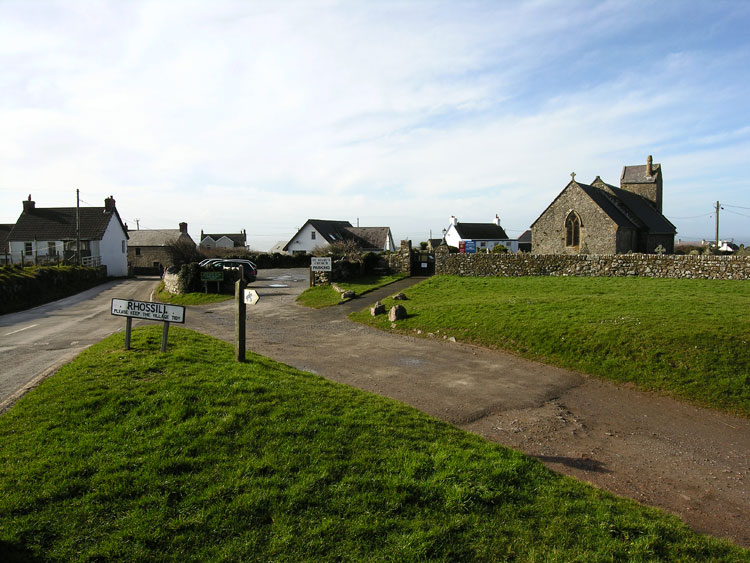
HLCA031 Rhossili and Middleton
Post-medieval/medieval settlement and agricultural landscape: nucleated organic settlement with later ribbon development; varied fieldscape; medieval strip fields; traditional boundaries; ecclesiastical centre; post-medieval vernacular buildings; rural and processing industrial features; and historic associations. Back to Map
Historic Background
The historic landscape area of Rhossili and Middleton roughly equates to the medieval Manor of Rhossili, excluding area of common land of Rhossili Down to the north and the Vile field system to the west. The area of Rhossili was located within the Welsh medieval Cwmwd of Gwyr, within the Cantref of Eginog. During the reorganization of the post-medieval period the area formed part of the Hundred of Swansea, within the County of Glamorgan.
Rhossili is possibly mentioned in the book of Llandaff in c.650; Davies (1979, 97) interprets the text of this charter as possibly indicating that there was main monastic estate at Rhossili with dependent cells elsewhere on Gower, a second charter of c.925 also refers to the monastic establishment at Rhossili. The de Turberville family is assumed to have held Rhossili, one of the dispersed holdings of the Manor of Landimore, until they were dispossessed by William de Breos II during the thirteenth century. The first record of St Mary's Church at Rhossili (00153w) follows the Norman annexation of the area, when William de Turberville granted the church at Rhossili, together with those at Landimore and Llanrhidian to the Knights Hospitaller of St John at Slebech in Pembrokeshire between 1135 and 1230. The dedication of the church to the Virgin, confirmed by Merrick (ed James 1983, 118), is thought to date to the twelfth century (Davidson et al 1987, 257; Evans 2003-04). The Knights of St John continued to appoint the rectors until the dissolution of the order in 1540, thereafter until the disestablishment of the church in 1920, the rectors were appointed by the Crown.
During the thirteenth century Rhossili is thought to have comprised two independent settlements with their respective churches, as indicated in an account of a marriage which occurred during the period of 1217-1220; the dowry specified "Landymore, Rhossili the greater and the lesse". Archaeological evidence has proved the existence of a lower settlement (HLCA 013; SAM GM414) with its church. The two settlements and their churches appear to have co-existed until the late middle ages Whilst the fabric of the church of St Mary's is largely of fourteenth century date, with an impressive twelfth century Norman style chancel arch; the possibility exists of the latter feature originated from the Lower church, a theory supported by local tradition, and excavation has confirmed that dressed stonework appears to be missing from the chancel wall of the older church (see HLCA013 for further details). A finger sundial scratched on the left column cap of the Norman arch shows it was at one period an external door.
The medieval church of St Mary (LB 11547 II*) is a much-restored church of fourteenth century date, incorporating a fine Norman southern doorway of the twelfth century, unique in Gower. The following is based on the listed building description and other sources.
The church is considered to have originally comprised a nave and chancel only and early mediaeval features include a low-side-window and the slight inclination south of the axis of the chancel. The church is constructed of local axe-dressed conglomerate sandstone masonry apart from the dressed stone (a combination of sandstone and oolitic limestone) of the windows and doors. The west tower appears to be an addition, blocking an earlier high level west window and has a transverse saddleback roof without parapets and slit belfry lights to north and south and a round chimney. The east window is in Decorated style with two cinquefoil main lights and a quatrefoil top light. Label-mould to this window only with carved heads as terminals. The north and south windows of the chancel are broad trefoil-headed lancets. The low-side-window in the south wall of the chancel is a re-opened mediaeval window, with a slight ogee point. The three windows to the north of the nave and five to the south are all broad featureless lancets.
There is a plain half-round outer arch to the porch. The inner doorway is the special feature of St Mary's: a two-order arch, the inner order plain apart from a jamb chamfer with decorative upper stops. The outer order is decorated with two bands of outward-pointing chevrons and nook-shafts with carved caps. Dogtooth label-mould with small oval carved head now slightly left of centre; carved heads as terminals. The left terminal head is more worn; the right head is larger and may be later. There is also a finger sundial in the abacus of the left capital.
A drawing in 1855 by Caroline Lucas suggests considerable dilapidation by this period and the church was much restored from the mid-19th century with much of the cost borne by Miss Talbot of Penrice. The church was re-roofed and re-paved; the porch rebuilt; the two windows were added in the west end of the nave, a window in the south wall of the tower, and the low-side-window was re-opened and glazed; also the base of the tower was formed into a vestry. The slate roofs with tile ridges were further repaired in 1970, and a screen erected at the west of the nave to enlarge the vestry (Lucas 1982; Newman 1995, 541; Orrin 1979, 77-80).
The churchyard at Rhossili (05252w) is a partly curvilinear churchyard, both now and on the tithe map of 1847, where it is shown as occupying the northern half of a curvilinear block entirely surrounded by roads; it looks as though it probably originally occupied the whole of the block, which was then divided by a straight boundary to leave the churchyard occupying only part. It slopes down slightly from west to east, and is raised above the surrounding area to the west The present boundary is of coursed rubble, which at the west end forms a retaining wall; there are two single gates, linked by a path round the south side of the church (Edith Evans, 2003-04).
The description below relates primarily to the settlement of Upper Rhossili. The area is based around the village of Rhossili, a nucleated organic settlement centred on its medieval church, St Mary's, and the hamlet of Middleton, a nucleated ribbon development or cluster centred on a road junction between the major east-west route to Rhossili and a minor lane to the open common of Rhossili Down. The two settlements are now linked by late twentieth century ribbon development, primarily of retirement bungalows and villas. During the eighteenth to twentieth centuries the area almost exclusively formed part of the holdings of the Talbot family of Penrice.
On the first edition OS 25-inch map Rhossili is little more than a small group of cottages and farmsteads grouped to the southwest and northeast of the curvilinear church yard of St Mary's church, extending from Harepits Cottage in the west, via Ash Tree Farm, Rhossili Farm and Bay Farm to the farm buildings of Little Hill House at the north adjacent to the lane extending from the Green, just northwest of the church to the open common of Rhossili Down. Also shown are a number of features relating to the rural industry of the area, such as a sawpit at the Green, a quarry west of Harepits Cottage, and an old limekiln to the north. Little change is recorded on the second edition OS map, apart from minor additions including the addition of a coastguard station (now the Old Coastguard Cottages) and a range of three buildings including Wormshead Cottage to the west of Harepits Cottage. The later Coastguard Cottages on the route to Worms Head, now the National Trust Shop were erected during the 1930s.
At the turn of the 19th -20th century the hamlet of Middleton comprised a dozen or so two-storey white washed cottages with small square windows and roofs of slate or thatch, including a shop, Post Office, a forge and the Ship Public House associated with Petty Officer Edgar Evans (1876-1912) who accompanied Captain Scott to the South Pole and died on the return journey. The Ship was closed in the early 1900s after a Methodist inspired temperance petition was submitted to the Lady of the Manor, Miss Talbot of Penrice. The hamlet of Middleton, as depicted on the first edition OS 25-inch map, comprised a slightly larger settlement than that at Rhossili itself, even though devoid of the parochial centre, and in addition to the Ship Public House at the west end of the settlement, comprised several farmsteads at the cross-roads, namely Jessamine Farm, Middleton Hall, and a cottage and outbuildings, since demolished to make way for road widening. To the east ribbon development extended along the south side of the road as far as Mewslade Cottage (Post Office on 2nd edition), whilst to the north of cross-roads on west of the lane to the common was a cottage (now known as Riverside) and a house named as Old Farmhouse, slightly to the north is a sawpit, a number of cottages and a smithy. The lane continues as a track along the edge of common land via Middleton Hall Cottage to a group of cottages at Fernhill Top set within enclosures taken from the common. Talgarth's Well is depicted slightly to the south. By the publication of the second edition of the 25-inch OS map the Weslyan Methodist Chapel (built 1887) had been constructed at the eastern edge of the area, approximately equidistant from Middleton and Pitton. The second edition records a smithy at the cross roads and the addition of a school on the southern edge of the common.