Gower
038 Cefn Bryn Common
HLCA038 Cefn Bryn Common
Unenclosed common land: prehistoric, funerary and ritual landscape; possible prehistoric occupation; routeways and trackways; historic association; water supply; minor industrial and agricultural features. Back to Map
Historic Background
The historic landscape area of Cefn Bryn Common is defined by traditional limits of unenclosed common land within the parishes of Llanrhidian, Nicholaston, Penmaen, Penrice and Reynoldston, and includes Frog Moor.
Cefn Bryn Common is an area of raised ground reaching a maximum height of nearly 190m OD steeply sloping to the south and west, with its main ridge running southeast - northwest from Penmaen to Hillend. A small plateau exists above Reynoldston, northeast of this the common slopes relatively steeply then more gently stretches out to Cillibion. It is clear that this area played a significant role in human activities during the prehistoric period. Occupation during the Mesolithic may have been revealed during excavation of Cefn Bryn Great Cairn; when flints artefacts possibly dating to this period were discovered in a sealed context beneath the cairn.
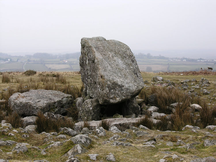
Two chambered burial tombs dating from the Neolithic survive on the common. Maen Ceti or Arthur's Stone (SAM GM003; 00068w; 95736) is one of the most well-known monuments in Gower, situated on a north facing slope, just north of the main road that crosses the common; with views across Llanrhidian Marsh to the Loughor estuary. It is a large double-chambered Megalithic tomb within the remnants of a round cairn capped by a large stone of Old Red Sandstone conglomerate, of an estimated weight of 25 tons. A chambered long cairn (SAM GM167; 00273w; 94594) can also be found on the edge of the common just above Nicholaston with good views out towards Oxwich Bay.
Use of the area for the siting of ritual monuments increased greatly during the Bronze Age as evidenced by forty or more cairns largely situated along the ridge of the down. Both round and ring cairns are present varying in size and belonging to a number of identified cairnfields (00082w, 00083w, 02094w, 02234w, 02235w, 00530w, 300050) on the common. The cairns appear to be characteristic of sepulchral structures; a number of which are scheduled (SAMs GM038, GM153, GM196). These monuments can be seen to belong to a wider Bronze Age ritual landscape including Llanmadoc Hill and Rhossili Down the upland areas and ridges playing an important role in ritual and perhaps defining territories. That known as the Great Cairn Ring Cairn (SAM GM196; 00078w), near Arthur's Stone has been reconstructed after excavation by Anthony Ward. Ward recorded the small quantities of bone and interprets the site as being a "forum for wider ceremonials of symbolic practice" (Ward 1981) rather than a repository for the dead. Excavation of a second ring cairn (Ward 1982) on the common also displayed no evidence for burial.
Domestic occupation of the area during the early prehistoric period is evidenced by a hearth and posthole discovered during excavation of the Great Cairn. A number of burnt mounds (SAM GM543; 00284w, 04788w; GM436; 02436w; GM544; 02144w; 00191w; 00272w), enigmatic in function are thought to be cooking or feasting mounds, but may also be ritual in nature. Further interpretations have suggested their use in saunas or sweat houses given that they are located close to water sources.
Archaeology relating to the Iron Age has not been found on the common. However, occupation of the surrounding area dating from this period is evidenced by an enclosure at Reynoldston and a fort at Stembridge. Their close proximity to the common and given that Hillend was relatively recently enclosed suggests continued use of the area through the Iron Age.
During the Medieval periods the open common land formed part of an agricultural system, combining arable sharelands on the lower ground with open access to the common, used by the villagers as grazing land for livestock. Enclosures on the common of uncertain date may relate to some agricultural practice or control of livestock. Encroachment of the Gower commons took place from the sixteenth century onwards; this seems to have been piecemeal and minor on as compared with elsewhere in Gower. Examples established by the eighteenth century are the enclosures around Hillend, Freedown and Stoneyford. A possible post-medieval farmstead near Arthur's Stone, excavated by Anthony Ward, comprised of a number of structures, including a possible forge and stone yard. Use of the area for grazing livestock continues until today.