Gower
034 Llanddewi
HLCA034 Llanddewi
Post-medieval/medieval agricultural landscape and medieval ecclesiastic manor: evolved semi-regular fieldscape; traditional boundaries; ecclesiastic and early medieval associations; post-medieval settlement and agricultural features; deserted medieval settlement; and agri-industrial features. Back to Map
Historic Background
The historic landscape area of Llanddewi is defined by the long-established boundaries of the Bishop of St David's Manor of Llanddewi. The boundaries also delineate an area of slightly larger enclosures when compared to the wider landscape.
Occupation of the area dates back to the prehistoric period attested to by finds of the period, including scrapers and a flake (00880w) and a Bronze Age polished stone axe (00176w).
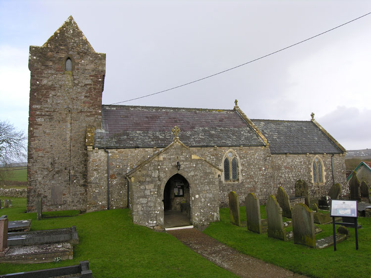
Little is known of the early history of the area, however, Llanddewi was probably a longstanding ecclesiastical centre with indications of early medieval origins from both its dedication to St David and curvilinear churchyard enclosure (Evans 2003), both demonstrating the importance of the area before the arrival of Normans in Gower. The Chantry or free chapel of Henllys in Llanddewi (05291w; 01457w; 11802), was surveyed in 1545 and 1547 by commissioners appointed by Henry VIII; of this no surviving remains are known (Evans 2003a) and it may have been located either within this area or the adjacent area of Henllys (HLCA 033). The fourteenth century church (00185w; 400408; LB 22793 II*) at Llanddewi is reputed to have been constructed by Henry de Gower, Bishop of St David's (1328-47) in conjunction with a castle or palace, however, it seems that the palace was abandoned due to a deficiency of water in the area, this is mentioned in the Statutes of St David (Orrin 1979: 37, SAM GM334 description). An earthwork 450m southwest (00160w; 305468; SAM GM334) of the church on a triangular area of common near the centre of the area has been conjectured as relating to the aforementioned palace site, however, others report it as an enclosure of Iron Age date, which is questionable (SAM description).
During the medieval period settlement at Llanddewi was more extensive, remains of a deserted settlement (00856w; 400409) can be seen to the northwest of the church. The extent and nature of remains and date of abandonment is unknown. By the time of the 1841 tithe map, the area was still owned by the Bishop of St David's, however, Llanddewi encompassed a larger parish mentioned in the sixteenth century by Merrick as comprising of three lordships or manors: Llanddewi (this HLCA) belonging to the Bishop of St David's, Scurlage belonging to Sir Edward Mansel and Henllys owned by Henry Mansel.
Settlement depicted on the tithe map is limited to the church and the main farm (Llanddewi Castle) opposite with a cluster of associated outbuildings. The main farmhouse (19155) of sixteenth century date is thought to be situated upon and composed of the remains of a castle or fortified manor house (00173w; 00174w; 02211w), possibly indicating an alternative location for the 'palace' of Henry de Gower. Merrick writing in the sixteenth century says 'Within the lordship of Llanddewi was an old castle of that name' (James 1983: 121). The present house may have some fabric dating from the fourteenth century. By the mid-sixteenth century Llanddewi Castle had become the manor house of Phillip Mansel and was rebuilt during this period (Morris 1998).
Comparison between the tithe and first edition OS map appears to show no change or additions to the settlement pattern. The field pattern is almost identical consisting of relatively large enclosures formed from consolidation of a former strip field system. A roughly triangular area of common land (a possible location of the Bishop's palace) is connected to the clustered settlement by a thin band of commonland running eastwards. A green lane, now a well-established track runs westwards representing a longstanding route to Henllys. A short lane runs north providing access to the main road possibly replacing an earlier route or holloway depicted on aerial photographs running to the site of the deserted settlement. The only more recent changes to have taken place are the addition of modern agricultural buildings and two houses, Sunnyside and Cartref, as well as extensions to the main farmhouse. The former vicarage on the first edition OS map to the east of the church is now a village hall and all other agricultural buildings survive in tact dating back to at least the early nineteenth century. A new vicarage was constructed by the survey of the third edition OS map close to the junction of the main roads, this is now known as Llanddewi Villa. The field system toady remains practically identical to that on the first edition OS map.
Also depicted on the first edition OS map are a number of quarries, a reasonably well-preserved limekiln (02462w) is associated with an quarried area just west of the main road (A4118). It is likely that other limekilns operated in the area from the post-medieval period when change in agricultural practice resulted in an increase in the use of lime as fertiliser, this greatly increased in the nineteenth century as elsewhere in Gower.