Lower Wye Valley
035 Wyesham
HLCA 035 Wyesham
Post-medieval (19th century suburban clustered and mid-20th century planned nucleated) settlement dominated by transport and communication; 20th century housing estates (social and private), leisure facilities (Tennis courts and school playing fields, and sports ground) and industrial estates; post-medieval and 20th century settlement features/building types; communication features (major roads; disused industrial and public rail); ecclesiastical features: medieval chapel and19th century church (St James) and cemetery; site of post-medieval (19th century) industrial features. Back to map
Historic Background
The historic landscape area of Wyesham is an area of modern residential suburban development, transport and communication. It forms part of the modern urban growth of Monmouth and occupies the east bank of the Wye, opposite the main historic centre of Monmouth itself. Its boundaries are defined by the extent of modern development. The hamlet of Wyesham lies in the parish of Dixton, and was held by Edward, the fourth Earl of Worchester in 1607. It descended through this family, which became first the Marquises of Worcester and then the Dukes of Beaufort. By the time of the tithe map (1845) the majority of the area of Wyesham belonged to the Beaufort estate, and was leased to various smallholders.
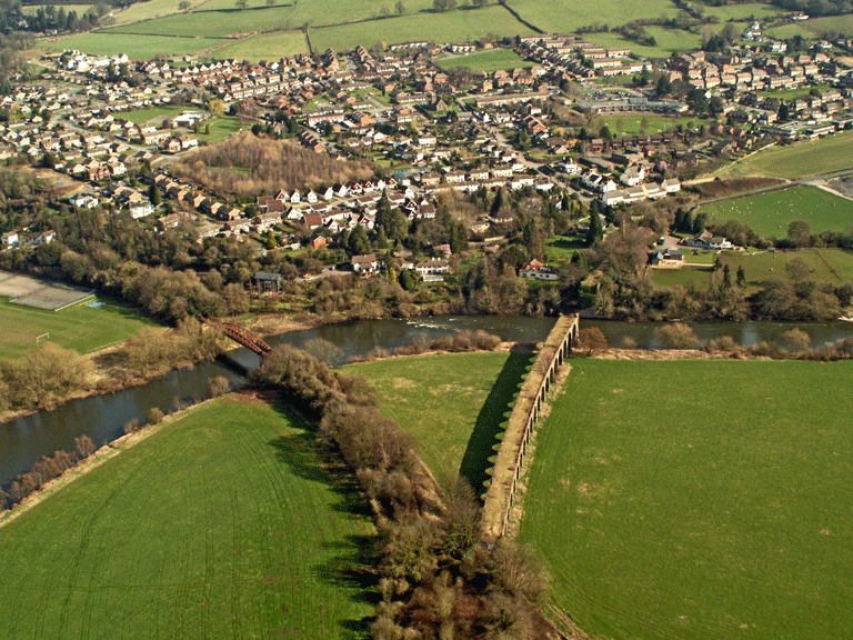
The area was evidently important in the medieval period, as a timber bridge over the River Wye linked the area to the town of Monmouth in the fourteenth century. The present bridge dates to a complete rebuild carried out in 1615/1617, and later widened on both sides in 1878-80, under the architect Edwin Seward of Cardiff, commemorated by a plaque stating, 'This bridge was widened 1879 from designs by the County Surveyor, David Roberts Contractor'.
During the medieval period Wyesham was the site of a chapel, the Church of St Thomas the Martyr; the site is first mentioned in 1186 in a papal bull of Urban III, and was known as the King's Chapel by 1500. Its later history is somewhat chequered; it remained in use as a place of worship until becoming the vicarage of Dixton Church in 1740, subsequently by 1815 the local Poorhouse. It has been a private house since the end of the nineteenth century.
The most important periods in the development of Wyesham are the post-medieval and modern periods, due largely to the construction of railways and tramroads running through it, and to the station at May Hill, which was a stopping point on some of the lines, and a terminus on others.
The first of these lines was the Monmouth Railway, a tramroad authorised by an Act of 1810, and completed in 1816/17, which ran from Howler's Slade in the forest of Dean, through Coleford, Newland and Redbrook to terminate at May Hill station. Following this, the Coleford, Monmouth, Usk and Pontypool line was authorised under an Act of 1853, with a branch serving the Gas Works at Wyesham. This line ran from Little Mill Junction to Wyesham station, and the section to Monmouth was opened in 1857. Subsequently, the Ross and Monmouth Railway constructed the line from Monmouth to Ross-on-Wye in the 1860s; this line was authorised by an Act of 1865, and opened in 1873. This line terminated at May Hill until an extension to Troy station, south of Monmouth was built the following year. The construction of the Wye Valley Railway in the 1860s, authorised in 1866, and opened in 1873, included the Coleford branch from Wyesham, which opened in 1883. Although small local companies initially constructed these lines, they were later gradually taken over by the Great Western Railway.
The development of Wyesham as a residential area can be seen on the tithe map of 1845, which shows the area as a small residential suburb of Monmouth, with several clusters of cottages and villas. The importance of Wyesham as a hub of communications and transport can already be seen to be developing on the First Edition OS map (1881), which depicts a cluster of industrial buildings around May Hill station. This area of suburban residential settlement, remains in a similar form up to the Third Edition OS (1921), and then changes completely in the course of the twentieth century. The earlier, loosely dispersed suburban settlement of cottages and villas is subsumed in very densely developed areas of council houses, built between the 1920s and the present, with significant development in the 1950s by John H Evans for Monmouth Borough Council (Newman 2000 605). The Second World War also left its mark on the area; a pillbox was constructed at the junction of the A4136 and the A466, to guard the southern approach to Monmouth up the Wye Valley.
Historic Landscape Characteristics
Wyesham is characterised largely as an area of industrial settlement of mid-twentieth century suburban development of social housing. This development overlies an earlier suburb of nineteenth and early twentieth century date shown on the OS 1st edition, a dispersed scatter of villas, country houses, farms and cottages, including a School (Boys and Girls). The mid-twentieth century development has rendered the area almost unrecognisable from the maps of the early 1920s, and the landscape is now very densely settled. The current settlement pattern is clustered and planned; primarily terraced, with some semi-detached houses, and modern bungalows. The housing of the area is considered to represent a good typology for tracing council house development from the 1920s, with a range of styles from garden village, to modernist. There are also speculative developments in a neo-Scandinavian style. A few older post-medieval cottages and detached 19th century villas (eg Wyesham House, and Mayhill House, a hotel from the 20th century) are also in evidence. The building material of the mid-twentieth century building stock is primarily brick, with some moulded concrete construction and wooden cladding, with pantile and concrete tile roofing. Whilst in contrast, the earlier buildings are characteristically constructed of coursed stone, rendered or whitewashed, with slate roofs.
Business and industrial development, and related transportation and communication, are a characteristic of the area and have a precedent in nineteenth century Wyesham. First Edition OS maps show some industrial development, for example Brick and Lime works, Gas Works, the Monmouth Waterworks and steam saw mills to the northwest of the area, along the banks of the Wye and the line of the railway. This part of the area is now a large industrial estate and factory site, with several very large modern commercial buildings, and a sports centre.
As well as encompassing the east bank of the Wye, there are also medieval, post-medieval and modern transport features in the area. Communication elements include: major roads (A466), industrial rail including an old tramway, depicted on the OS 1st edition, the line of the Monmouth Tramroad of 1812, and public rail (now disused), and the associated site of Mayhill Station (OS 1st edition).
There has been a bridge connecting this character area to the centre of Monmouth since the medieval period. The Wye Bridge, protected by Grade II listed building status; (PRN 01250g, LB 2220) occupies the same site as the important medieval wooden bridge, extant in the fourteenth century (Rees 1932, SE sheet). The bridge was rebuilt in the early seventeenth century, when it was also given corbelled out parapet walls to carry footways. A shield on the centre pier may originally have given a date of either 1615 or 1617, although no trace of this now survives. A plaque on the parapet, dated 1879, commemorates the widening of the bridge by Edwin Seward of Cardiff. The bridge is built of red and buff sandstone ashlar, which has been significantly patched. It may originally have had seven spans (Map in Coxe An Historical Tour in Monmouthshire 1801) but only five are shown on the tithe map of 1843, and the existing structure has five arched spans, with the original pointed arches visible beneath. Additionally, the flood arches, part of the structure of the bridge itself on the Wyesham side of the bridge are also protected with Grade II status (LB 85195).
The First Edition OS maps (1881) show major public railway lines running through the area, connecting to the northeast, west and south. The now dismantled Pontypool, Monmouth and Ross section of the former Great Western Railway ran from the east, through this area from north to south, then turned west and crossed the Wye to the south of the area. The Wye Valley Railway that defines the transport corridor to the south (HLCA039) was also connected to Wyesham via Troy Station.
An additional dimension, which adds to the character of the area are the ecclesiastical features, some of which date to the medieval period. The Cell (PRN 01264g, LB 17399) is formed out of the medieval Chapel of St Thomas; the present front was the side elevation of the chapel. First mentioned in a papal bull of 1186, when it was granted to Saumur Abbey, it has now been converted into a house; in the eighteenth century, it served as Dixton vicarage, in the early nineteenth century it was a poorhouse, its current incarnation is a private dwelling called 'The Cell'.
The current ecclesiastic character is visibly provided by the Church of St James (LB 81041 Grade II), built in 1873-75 by J P Seddon, its tower completed in 1890. The church sits in the centre of the churchyard, which contains the modern cemetery. The gate piers and gates of the church at the east entrance are also protected with Grade II Listed Building status. Like the other earlier buildings in Wyesham, modern housing now surrounds the church.
A further, minor defensive characteristic is represented by a Second World War pillbox (PRN 04303g), which sits at the junction of the two major roads, which run through the area; the A466 and the A4136, facing south down the A466. The pillbox itself is rectangular, concrete-faced, possibly of brick construction. The presence of this defensive feature suggests that Wyesham was a strategically important defensive location, at the junction of two major roads, and on the main approach into Monmouth from the east and south.