Gower
044 Port Eynon
HLCA044 Port Eynon
Post-medieval/medieval settlement and agricultural landscape and manorial centre: varied fieldscape; nucleated organic settlement and loose dispersed scatter; post-medieval vernacular buildings; buried archaeology; coastal and maritime features; rural industry - extraction processing and rural crafts. Back to Map
Historic Background
The historic landscape area of Port Eynon represents the former manor of Port Eynon encompassing the main settlement on the edge of the bay, and the neighbouring hamlet of Overton, together with the associated field system. The area borders the former Manor of Paviland to the west, Horton to the east and Scurlage in the north. Port Eynon is in part designated as a conservation area (EV 9) in the Swansea Unitary Development Plan.
Little archaeological evidence is recorded of Port Eynon earlier than the medieval period other than flints scatters found in the Bay, at Overton cliffs, and elsewhere. The Glamorgan County History (Vol. II) describes the finds as dating from the Mesolithic or Neolithic period however they are only recorded briefly in the SMR as prehistoric tools, a group of 21-30 assorted tools considered to be domestic.
Port Eynon has been a popular fishing location for hundreds of years renowned for its catches of bass, mackerel and oysters in particular. A number of 'ports', usually consisting of a single pier, sprung up during the medieval period along the Gower shore and similarly along the Devonshire coast, giving greater access for trade of livestock, dairy produce, corn and limestone. The bay was particularly convenient due to the proximity of the steep limestone cliffs to the shore and the demand for limestone, and access to neighbouring farmland was easy along the established road system. Nearby post-medieval barns at Moorcorner Farm (02675w) and Newhouse Farm (02676w) used to store corn still survive intact.
During the medieval period it is recorded that Sir Edward Mansel, built a port however it is more likely that he improved already existing facilities. Mansel had endeavoured to keep hold of the district due to an old family claim, its potential for trade was no doubt attractive and he reaped the rewards of keelage and salvage from occasional shipwrecks.
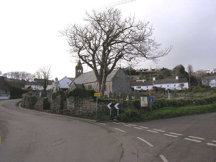
The church of St Cadoc (Cattwg) was reputedly founded in the 6th or 7th century by St Cennydd, a missionary of St Cattwg. The fabric of the church dates largely to the 14th, 16th and 19th centuries though the foundations may well date to the 13th century. The church is mentioned in 1230 and was ceded to the crown from the Knights of St John in 1540. It was not until 1861 that the church was restored and enlarged, further restoration followed in 1901 and in 1932. The contents of the church apart from the font are Victorian or later. Its churchyard is a partly curvilinear enclosure, indicative of an early foundation, set at the centre of the village.
The Salthouse (SAM GM471) was built for John Lucas and his wife in the mid sixteenth century by his father David; John later fortified the house fuelling the legend of his career as a smuggler and a pirate. The site was reputed to have had a secret passage as a means of escape, though there is little evidence of this. Port Eynon however has many tales of smuggling; it is reputed that at one point as many as eight excise men were stationed in the bay. The Salthouse was developed during the mid sixteenth century into the 3 unit industrial structure and processed salt water until the late seventeenth century. The Glamorgan-Gwent Archaeological Trust excavated the site between 1986 and 1988 with the purpose of studying sixteenth century salt-making technology. The site, represents a very early example of its kind, the process only becoming widespread during the eighteenth century; only a handful are attributable to the period in Wales. Later the building was used as Oyster-fishermen's cottages, as the trade was one of the main employers in Port Eynon. Another profitable business was limestone quarrying; a number of kilns in varying conditions are situated in this character area.
The church houses a number of dedications, most famous the memorial (00182w; LB 22790 II) in the churchyard from the 1916 Lifeboat disaster, where three local men lost their lives. The Lifeboat station still stands in a good state of repair, though it ceased operation as a lifeboat station in 1968 when the service moved to nearby Horton; today the building is a youth hostel.
Of the area's post-medieval buildings Overton House (02674w; 19,552; LB 18050 II), built in the seventeenth century with eighteenth century development, is of considerable interest; it retains a settle and charnel box of probable eighteenth century date. The latter feature is considerably rare, only one of three to survive in Gower, and a feature more commonly associated with Devon. As such, it emphasises the cultural links between the Gower and the west of England along well-established trade routes.
The first edition 25-inch OS, 1879, shows settlement nucleated around the church at Port Eynon, and at Overton, little development is recorded in the 2nd OS map, 1898, or the 3rd in 1915, most occurs in the latter part of the twentieth century with the housing around the northern side of St Cattwg's church, along the short length of road towards Overton, though presently Overton remains a separate settlement with the enclosures of New House farm acting as a green barrier. Other more recent additions to the area are the various holiday camps, two around Port Eynon and the other towards Scurlage on the northern border of the area.
At the time of the survey of the first edition OS maps, the settlement at Port Eynon comprised a number of cottages and farmsteads surrounding the medieval church set within its sub-circular churchyard; housing extends to the south along the road to the coast in ribbon fashion, with houses predominantly fronting the street, though with a few set at right angles within narrow linear plots. A side lane heads off east, past the Ship Public House, and other cottages towards the dunes and coastal common. To the north of the church a staggered lane leads northeast to a narrow linear area of enclosed common which extends into the adjacent area (HLCA 045) and the settlement of Horton; this area is characterised by rough land with limestone outcrop and quarries. Within the adjacent HLCA these quarries are associated with limekilns. Northwest of the village centre, just south of the junction with the lane to Overton is the local smithy, set apart and at some distance from the settlement itself. Further north is the village school (Boys and Girls).
To the west of Port Eynon, the settlement of Overton to the west of New House Farm has a scatter of cottages and farms located around the edge of its green, these include the farm of Overton at the western end of the green. There are at least two farms and associated buildings depicted along the route heading north from the green.
The associated fieldscape is little changed in term of pattern since the first edition OS, apart from minor amalgamation of enclosures; the greatest change appears to have occurred in the area to the north of the track between Margam Farm and Moor Corner Farm, and the lane to Hangman's Cross, an area, which with its more regular planned rectilinear layout, appears to have been enclosed earlier from moorland common. Remnants of the former medieval open field associated with the settlements of Port Eynon and Overton is still discernable in the modern landscape, as fossilised linear strip field enclosures, accessed from the routes leading north from the two settlements. To the north of Hills Farm there is an area of very regular rectangular fields; the boundary south of Hills Farm may mark the division between the former open field and the associated meadows or hill land to the north. There are at least two quarries and associated limekilns in the area of the former moorland at the north of the area, named as old on the first edition 25-inch OS map; these features probably relate to agricultural improvement of the surrounding land.
The quarrying and shipping of limestone, alongside the inshore fishing trade, appears to have been important to the inhabitants of Port Eynon and provided considerable employment and income. The quarrying activity appears to have been largely based along the adjacent coastal margins and probably took place between April and September. The quarried stone would have been brought down to the shore by cart at low water and loaded onto boats at the following low tide. Visible remains of this trade with Devon (primarily Barnstable and Bideford) are provided by areas of ships' ballast (blue-green stones and boulders) on the adjacent foreshore. Lewis records in 1833 that the parish of Port Eynon 'abounds in limestone, procured in large quantities for export and also supplying neighbouring districts'.
The trade in quarried limestone from Gower died off at the end of the 19th century, presumably because more sophisticated fertilisers became available and rail travel began to supersede shipping. The last load of limestone for Devon was carried aboard the 'Roe' in the summer of 1876.