Gower
042 Mumbles Head and Rotherslade
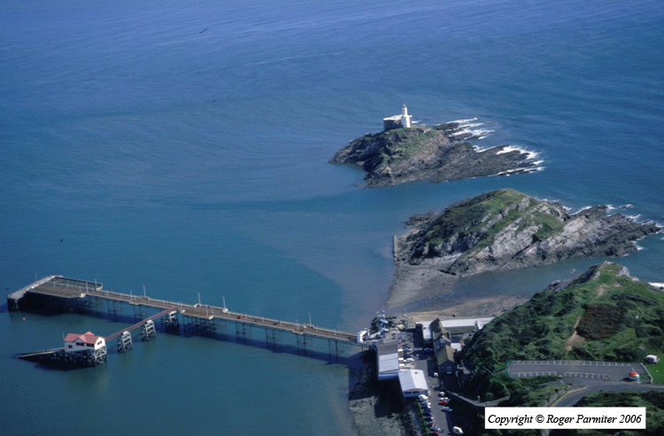
HLCA042 Mumbles Head and Rotherslade
Intertidal zone and unenclosed coastal margin: coastal and maritime features; quarrying, defensive sites; buried archaeology; tourism. Back to Map
Historic Background
The historic landscape area of Mumbles Head and Rotherslade equates to the unenclosed coastal margin (cliff edge and unenclosed hill) between Rothers Tor and Mumbles headland as well as the intertidal zone between Langland Bay and Mumbles. This area lay within the former demesne manor and parish of Oystermouth.
In common with other coastal areas in Gower, caves are present along the rocky foreshore and cliff edge. Rothers Tor (01431w) and Inner Sound (01426w; 04714w) caves have both produced remains of animal bones. Inner Sound, the easternmost of the Gower 'bone caves', was discovered by quarrying in 1838 and the bulk of the bones were thrown into the sea. L. W. Dillwyn rescued some of the remains of the straight-tusked mammoth, which are now on display in the Swansea Museum. No human remains or evidence of occupation was discovered although inference from surrounding areas notably Swansea Bay demonstrates activity in the area from at least the Neolithic and finds from west Gower caves date back to the Palaeolithic.
No direct evidence comes from this HLCA dating to before the post-medieval period; however, occupation of the Oystermouth area during the Roman period is attested to by a possible villa site on the site of the parish church from which Roman finds have been made. Nearby Oystermouth church and castle of twelfth and thirteenth century dates respectively indicate further establishment of settlement within the surrounding area. From the medieval period onwards the cliff edge and common were most likely used for grazing animals.
One of the main activities within the area was quarrying of limestone from the cliff faces and caves for transportation to elsewhere on the South Wales coast and Devon. This accelerated during the post-medieval period; from 1650 the lord of the manor is reputed to have had a quarry on mumbles cliffs (Gabb 1986). Captain George Phillips signed a lease from the Duke of Beaufort in 1844, which allowed him to quarry from the Knab to Braclet Bay. By 1850 such large quantities of stone had been removed from the area that an inquiry was set up to determine whether this had affected the sheltered anchorage of shipping in the bay (Gabb 1986). A large number of human remains (02999w, 00467w) were found in fissures in the rock; these were tentatively dated to the medieval period, some being described as bodies of casualties of war and others as being associated with the graveyard of an old chapel in the nineteenth century, however, there is no firm evidence to support this date. A large quarry on Mumbles Hill is depicted on the first edition 25-inch OS map. Quarrying in the area came to an end in the 1960s. Iron Ore was also quarried on a small scale, a vein of which ran through Mumbles Hill; a smithy is located just outside this area (03096w).
This coastal area was important for shipping and maritime activities. The section of coast around Mumbles head was particularly treacherous. By 1793 a lighthouse (00828w; LB 11721 II*) was constructed on the outer island lit by coal fires, these were replaced by an oil lamp in 1799 (Gaab 1986). Many ships were wrecked off this coast even after construction of the lighthouse, examples are Hope wrecked 1806 on Mixon Sands, SS Tyne wrecked in 1919 after collision with the French Schooner Fleur de Mer and Protesilaus that hit a mine off Mumbles Head (Edmunds 1979). It was hoped that building a pier (00820w LB 11731 II) at Mumbles and linking this with the Mumbles Railway would increase trade from the area. Work was completed in 1898; but it was never used for trade and instead became a popular tourist feature (see below). Oystermouth is obviously well known for its oysters and evidence from surrounding areas indicate that this resource was exploited from the Roman period and probably before. In 1684 the Mumbles was regarded to have the best oyster beds in Britain. Oysters were gathered from the area up until the late 1930s.
In 1835, the Royal National Lifeboat Institution established a lifeboat station at Mumbles, (this is now located just off the later pier) in response to a petition after the loss of lives from so many shipwrecks on Mixon and Scarweather Sands (Edmunds 1979). There have been three lifeboat disasters, two during rescue attempts from other vessels; the worst known is that of 1947 when all members of crew lost their lives trying to aid the Samtampa who also lost all her crew.
From at least the eighteenth century the area played a more defensive role with gun batteries on Mumbles Island (02243w) and Mumbles Hill (03097w). These were successively replaced during the nineteenth and twentieth centuries. A battery (LB 22571 II) was erected near Mumbles lighthouse in 1860 as a precaution against French invasion. Furthermore remains of Second World War defences include gun emplacements (02244w), a magazine (LBs 22569 II; 22570) and searchlights (03102w, 03103w).
During the nineteenth century the Mumbles and associated coastline became a popular tourist destination, this area increased in popularity after the construction of the pier in 1898 and the extension of the Mumbles railway (02811.0w, 03101w). Paddle steamers that had been taking daytrip passengers from Oystermouth from the 1830s now landed at the pier. One of the largest companies was P. and A. Campbell and Company Ltd, featuring sailings to Weston-super-Mare, Clevedon, Minehead, Ilfracombe and Lundy island (Gaab 1986). During the early twentieth century the pier boasted a variety of activities, amusements and entertainment, including bands, aquatic sports, and concerts. In the nineteen thirties the pier was taken over by the Amusement Equipment Co. Ltd who installed Dodgems and other games (Gaab 1986).
Mumbles is still a popular spot for tourism, many people taking walks along the cliff tops or down to Limeslade Bay, however, the pier is no longer as popular, although attempts have been made to revive some of its initial success. This character area is now used as a tourist area with recreational open space.