Gower
046 Penrice
HLCA046 Penrice
Medieval/post-medieval settlement and agricultural landscape and former manorial centre: small well-preserved nucleated settlement; dispersed farmsteads, varied fieldscape; woodland and plantation; relict archaeology; and rural industry: principally milling. Back to Map
Historic Background
The historic landscape area of Penrice represents the approximate extent of the former manor or Lordship of Penrice minus the core lands of later medieval and post-medieval estate of Penrice to the northeast with its stone castle and post-medieval gentry house, and the submanor of Horton to the southwest. The area encompasses the settlement of Penrice, formerly known as Mounty Brough and the monastic holding of the Sanctuary, together with associated field systems, and woodland plantation and enclosed former meadow/moor to the west. The area also borders the areas of Oxwich and Oxwich Marsh to the south and west respectively, whilst its northern bounds are with Scurlage and Reynoldston to the northeast. The village of Penrice (Mounty Brough) is designated as a conservation area (EV 9) in the Swansea Unitary Development Plan.
Little archaeological evidence is recorded for the area earlier than the medieval period other than an unassigned enclosure (00162w) noted on aerial photographs at Bryn Sil, which may relate to occupation during the prehistoric period or early medieval periods, but this needs further confirmation. The site, considered to be domestic, comprises an oval ring ditch c.5m wide, and encloses an area of 0.2 ha on ground rising very gently towards the southwest and falling away more steeply on other sides.
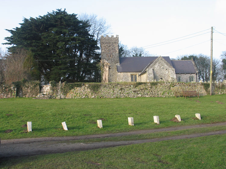
During the medieval period the settlement of Penrice initially formed the core of the fief of Mounty Brough (later the fiefs of Penrice and Horton), established in 1099 by Henry de Beaumont, who is credited with the construction of the ringwork known as Mounty Brough (00165w; 305472; SAM GM053), and the construction of the adjacent church of St Andrew (00186w; 11542), which is thought to have been a twelfth century foundation. Penrice (Pen-rhys) appears to given its name to the Penres family, who during the episcopate of David, Bishop of St Davids (1147-1176) granted the church to the Knights Hospitallers' Slebech Commandry; the grant is confirmed c.1180 by John de Penres and c.1200 by Robert de Penres. The church of Penrice was later appropriated to the Hospital of St David at Swansea, the endowments of which were confiscated and re-granted under Edward VI.
A further association with the Knights Hospitallers is found regarding the site of the post-medieval farmstead of the Sanctuary, the predecessor of which is said to have belonged to the manor of Millwood, or St John's, the property of the Knights Hospitallers.
The ringwork at Penrice is the third largest on Gower, after North Hill Tor and Norton, and the most massively constructed; a correlation has been noted between large size and early foundation. Penrice is one of the twelve 'ancient knights' fees' held by military service before 1135, which are listed in a charter of 1306 (RCAHMW 1991, 29-30, 113-115; Draisey 2002, 19; Nicholl 1936,168-169). The ringwork appears to have had a relatively short life, as it is thought to have been abandoned during the twelfth century, when they moved to the site of the larger stone-built castle to the northeast (see HLCA 047). The de Penres family remained at Penrice until the early-15th century, when the lordship passed to the Mansels by marriage. During the post-medieval period the main landowner of the area continued to be the Penrice estate, by the eighteenth century the Mansel Talbot family.
The first edition 25-inch OS, 1879, shows settlement much as it appeared on the estate plan of 1785 apart from the addition of a single cottage. The settlement is a nucleated cluster of cottages and farmsteads, set to the south of the church within its sub-rectangular churchyard. A comparison between the eighteenth century estate plan, the 1st edition OS map and current maps would indicate that the vast majority of the area's farmsteads and cottages survive, and that little has changed in plan since the eighteenth century. The possibility of interesting architectural survivals cannot be ruled out. A relatively high proportion of the area's smaller farmsteads and other dwellings, and shown on the eighteenth century map also appear on the 1st edition map and appear to survive to this day in some form, including Church Cottage, Marsh View, Rose Cottage, Sea View, and Bay View Cottage, though this can only be determined through further field investigation. The tithe map of c.1840 and the first edition 25-inch OS map depict a few nineteenth century additions such as Hillside Cottage.
Beyond the main settlement of Penrice are a small number of outlying farmsteads, including the mid-17th century farmhouse of Pitt, thought to have been built by David Bennet (d1666), or his son. The former, whose monument is in St Andrew's church, is recorded as tenant of Pitt in a survey of 1632. In 1670 eight hearths are recorded for Pitt Farm; the descendants of the Bennets remained at Pitt until the late eighteenth century (LB 11545 II*). In addition, the first edition depicts the farmsteads of the Sanctuary, Bysouth, Bryn Sil, Moor and Merrysun; a single disused limekiln is shown in the fields to the northwest of the latter.
The pattern of the associated fieldscape is essentially that of the first edition OS, and the estate plan of 1785, though considerable amalgamation of enclosures has taken place during the twentieth century to accommodate developments in farming practice, with the resultant loss of hedge rows. Remnants of the former medieval open field associated with the settlement of Penrice is still discernable in the modern landscape, as fossilised remnants of linear strip field enclosures, accessed from the routes leading south from the settlement, particularly around the Sanctuary and Pitt Farm. The area to the north and west of Bryn Sil Farm has undergone the most changes with radical realignment of previous boundaries, amalgamation of small enclosures into large fields, and the subdivision of previously open meadow and moor land, 'Mead Moor', to the west of the ancient woodland of Mill Wood.