Margam Mountain
003 Cwm Brombil and Graig Fawr
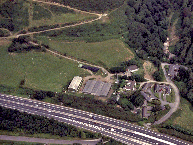
HLCA 003 Cwm Brombil and Graig Fawr
Steep west-facing hillside and deeply entrenched side valleys; mixed area of Ancient and other woodland and medieval/post-medieval agricultural enclosure developed from earlier valley core; multi-period relict landscape. Back to Map
Historic Background
The historic landscape area of Cwm Brombil and Graig Fawr comprises the west facing lower slopes of Mynydd Margam centred on the deeply entrenched valley part of the Margam Abbey estate during the post-medieval period. During the medieval period the area was associated with various granges of Margam Abbey's including Llangyfelach (later Maes y court), Cryke and Whitecross (Groeswen) granges; the latter south of the Wessac stream (Gwessig thought to derive from 'cwysig' a ditch or furrow) within Cwm-y-Geifr (previously Cwm yr Havod), and included Cwm Brombil, the site of a coal-pit owned by the Abbey. The area includes land formerly part of Lan Ton-y-Groes, an area of agricultural lay-land associated with the medieval Groeswen grange.
During the early post-medieval period industrial use of the area, at the time part of the extensive Margam Estate, continued; a gristmill is mentioned at Cwm Brombil in 1633, further alluded to in 1693. Collieries were opened between 1777 and 1780 in Cwm-yr-Afr (Cwm-y-Geifr) and Cwm Brombil by the English Copper Company to meet demands of the Copper industry; by 1814 an additional level had been opened up in Cwm Brombil. In 1838 the Brombil Tramroad, (horse drawn) was constructed, connecting the Cwm Brombil to Taibach Copper works, then operated by Messrs. Vivian. Cwm Brombil Colliery finally closed in 1880.
The area today is essentially a post-medieval agricultural landscape limited areas of earlier enclosure and Ancient woodland; the agricultural hinterland is largely divorced from its post-medieval farmsteads, apart from that of Brombil Farm (17th-18th century).
Historic Landscape Characteristics
Cwm Brombil and Graig Fawr comprises the steep lower slopes of Mynydd Margam overlooking the coastal zone with deeply entrenched side valleys; its character dominated by the landform of the area. Much of the area is characterised by Ancient and other broadleafed woodland, augmented by 20th century forestry. A more recent, but nonetheless dominant characteristic of the area is the area's post-medieval agricultural landscape, particularly towards the north of the area, in place by early 19th century; this is typified by large enclosures, developed within formerly unenclosed, and centred on evolved irregular fieldscape of small fields, possibly of medieval or earlier origin, within Cwm y Brombil itself. The area retains distinctive field boundaries. Of the area's post-medieval agricultural settlement only that within Cwm y Brombil, comprising the vernacular buildings of Brombil Farm (PRN 1731w) remains; this is a regional house with chimney backing on the entry and outside cross passage and fireplace stair and associated four-bay barn. The northern part of the area was associated with the farms of Groeswen and Groeswen pellaf, which lay to the west of the historic landscape boundary. Important relict elements of the landscape survive from all periods and include prehistoric, medieval and post-medieval settlement/fields, and prehistoric military/defensive feature(s); such as the Halfmoon Camp (PRN 0745w; SAM Gm 477), the small univallate hillslope enclosure above Taibach (NPRN 54,457) of Iron Age date; medieval pillow mounds (NPRN 54,461) and a group of medieval house platforms (NPRN 54,458 and NPRN 54,459) located on Mynydd Brombil. The area was formerly monastic grange land (part of Groeswen Grange) associated with Margam during the medieval period. Aerial photographs indicate buried archaeology represented by crop/parch marks also characterise the area. Recent additions to the character of the area include defensive features associated with World War II, the Home Chain Low radar station (PRN 02995w; SAM Gm 488). Other characteristics relate to the industrial exploitation of the area's coal resources; post-medieval industrial archaeological remains: coal levels/shaft and colliery tramway all at Brombil.