Margam Mountain
005 Llangynwyd
HLCA 005 Llangynwyd
Important diverse multi-period relict archaeological landscape, including: pre-historic and medieval settlement with associated field systems; prehistoric enclosures (upland agricultural landscape features); medieval military/defensive feature; post-medieval vernacular buildings; important well-documented historic associations; small, but important nucleated settlement with medieval (or earlier) origins, centred on medieval church and cemetery; dispersed scatter of settlement throughout the surrounding area; Ancient woodland. Back to Map
Historic Background
The historic landscape area of Llangynwyd is an important landscape with a variety of different elements. The focus of the area is on the nucleated medieval settlement of Llangynwyd and has been so since early medieval times, if not before. The area is essentially an evolved agricultural landscape, which retains indications of settlement and enclosure developed from the prehistoric, early medieval, medieval and post-medieval periods. The western fringe of the area is demarcated by late prehistoric defended enclosures such as Y Bwlwarcau and beyond the area, the camp at Rhyd Blaen-y-cwm, which control access to the high ground of Mynydd Margam. Y Bwlwarcau (SAM Gm 59), the more impressive of these important landscape features, comprises a multi-phase earthwork with an inner enclosure of 0.3 hectare. The inner enclosure, its entrance defined by a prominent bank, ditch and counterscarp bank, is surrounded by two or three concentric banks and ditches enclosing 7.2 hectares. The site partially overlies the slighter defences of an earlier and larger enclosure.
During the medieval period occupation of the same sites appear to have continued or to have been re-established; platform houses (probably occupied as seasonal hafodtai/hafodydd, or summer dwellings associated with permanent winter settlement sites or hendrefi elsewhere in the vicinity) are typical settlement features, reoccupying the defended area of Y Bwlwarcau (PRN 00116/NPRN 301,303 and PRN 01323/NPRN 15,248; SAM Gm 59) and established around Lluest-wen (PRNs 00112-00114; NPRNs 15,349-15,351). These sites, in occupation during the 13th and 14th centuries, appear to have been progressively developed during the early post-medieval period, becoming established as permanent settlements in their own right during the period. The farmstead of Lluest-wen with its associated enclosures and post-medieval lluest site is a good example. Similar processes appear to have been in operation elsewhere in the area with a fragmentary settlement/enclosure pattern developing into the wider enclosed agricultural landscape seen today. The enclosure pattern immediately adjacent to the settlement of Llangynwyd retains fossilised elements of a medieval 'open field' system, namely fossilised quillets or strip fields; a field pattern possibly imposed on the pre-existing early medieval settlement with its Llan or church enclosure.
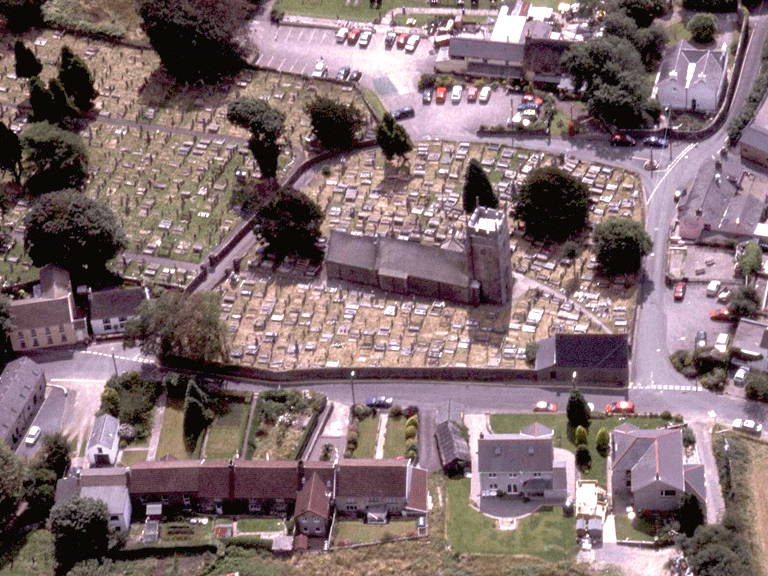
The church of St Cynwyd, which forms the focal point of the compact upland village of Llangynwyd, was initially established during the early medieval period, retains structural remains of the medieval period including the striking perpendicular tower and 14th century features such as a trefoiled lancet, priest's doorway with a keeled roll and twin trefoiled lancets. However much of the building dates from the drastic restoration undertaken between 1891-3 by G. E. Halliday at the bequest of the Miss Olive Talbot of Margam. The churchyard enclosure, or llan, at Llangynwyd is of a type roughly rectangular with curved corners, known elsewhere to date from the Roman period (cf. Whitton, Jarrett and Wrathmell, 1981). Other sites within the historic landscape offer possible prehistoric parallels, such as Caer Blaen-y-cwm, and Y Bwlwarcau, all of which have similar morphological elements. This could indicate, at least, reuse of an earlier enclosure, and settlement site, if not continuity of occupation over a considerable period; the site eventually developing a funerary and ritual significance during the early medieval period.
The other main focal point within the area during the medieval period is represented by the Llangynwyd Castle (SAM Gm85); a Norman structure, reconstructed by Gilbert de Clare in the 1260s. The site, originally with a great gatehouse with twin drum towers, was partly excavated in 1906. The Royal Commission have identified close parallels between the plan and defensive arrangements of the gatehouse at Llangynwyd and the inner east gatehouse at Caerphilly Castle, built by Gilbert de Clare from 1268.
During the post-medieval period landownership the area was held largely by four estates: Margam, the main landholder, Gadlys, Dunraven and Goetrehen. The development of the settlement of Llangynwyd during the period appears to have continued largely within the pattern established during the medieval period; a tight compact village unit centred around the medieval church and Llan including an additional terrace of rendered cottages ranging along the north side. The latter incorporated Bethesda Chapel of 1795-99 (senior church in the area for the Congregationalists/Independents); though modernised it retains two large segment-headed windows and a central single-storey porch. The parochial centre and village of Llangynwyd remained largely dependent on the local agricultural-based economy during the early post-medieval period, with a loose scatter of farmsteads of 16th and 17th century date, such as Llwydiarth and Gelli-lenor, being the main-stay of both the economy and of local Welsh culture. Many of the farms in the area have medieval precursors and associations with important Welsh cultural and literary figures.
During the 19th century the rise of industry in the area, principally iron and coal, was advanced by the construction in 1828 of the Duffryn, Llynvi and Porthcawl Railway (engineer John Hodgkinson). The line, 4ft 7in. gauge with edge rails of the type, which later became universal, ran for 25.7 km, and linked the ironworks of the Llynfi Valley to the port of Porthcawl. It is during this period that the focus of settlement in the area moved away from the old parochial centre of Llangynwyd to the then newly developing industrial settlement of Maesteg, in the valley bottom to the east.
Historic Landscape Characteristics
Llangynwyd is characterised as an important relict archaeological landscape; a palimpsest preserved within an interesting medieval/early post-medieval agricultural landscape. The dominant relict features comprise numerous and generally impressive prehistoric and medieval settlement with associated field systems. The latter includes monuments, which have a 'military/defensive' aspect, such as the impressive Iron Age Hillfort of Y Bwlwarcau (SAM Gm 59), with its pentagonal internal enclosure, and Llangynwyd Castle (SAM Gm 85), a medieval ringwork castle, with 12th and 13th century phases. There are also a number of deserted medieval settlements predominantly of the platform house type within the area; ranged along the upper western fringe of the area, close to the boundary of the open mountain of Mynydd Margam, these were associated with the management of cattle/sheep grazing on the grasslands of the open mountain.
Also characteristic of the area is the varied evolved/irregular field pattern, which includes remnant medieval strip fields and surviving corridors of Ancient and other broadleafed woodland. The character area, with its small nucleated-organic settlement centred on its medieval church, cemetery (early medieval foundation) and two holy wells, Ffynnon Gynwyd and Ffynnon Fair, retains a number of post-medieval vernacular buildings of interest, some of which are listed such as the Old House Inn (17th century core with thatched roof, listed grade II), Gilfach Ganol (16th century, with later additions, listed grade II), Llwydiarth (16th/17th century, listed grade II*), home of the Powell family, undersherifs to the Mansels of Margam during the 16th and 17th centuries and praised by Dafydd Benwyn (Tir Iarl poet fl 16th century), and Pentre Farmhouses (early-mid 17th century with attached farm range, listed grade II). Also of interest is the Corner House Inn, which was formerly the parish tithe barn; between 1761-62 used by Welsh Circulating Charity Schools promoted by the Rev Griffith Jones, Llanddowror. Many of the post-medieval settlements are considered to have medieval precursors, in particular Caer Emi, Gelli Eleanor (Gelli-lenor), and Pentre, among others in the region referred to in the Margam Charters of the 13th and 14th centuries.
The area has important well-documented historic associations, a literary centre of Glamorgan during the Middle Ages up until the 17th century, in particular, associated with the chief bards of Tir Iarll. Rhys Brydydd, Gwilym Tew, Rhys Goch ap Rhiccert (fl mid-14th century), Rhisiart ap Rhys Brydydd and Dafydd Benwyn, among many others were bardic poets associated with the area. During the 18th century the area was associated with Wil Hopcyn (d 1741), author of one of the most famous of Welsh Love Songs, 'Bugeilio'r Gwenith Gwyn'; the locality being the setting for the famous, tragic romance of the 'Maid of Cefn-Ydfa'. A memorial to Wil Hopcyn was erected between the Old House and Corner House Inn in 1927. Antiquarians Rice Merrick and Iolo Morgannwg among others visited the area, which is also renowned for its superstitions and traditions such as 'Mari Lwyd, and Gwyl Mab Sant.