Llancarfan
003 Kenson River Valley
HLCA 003 Kenson River Valley
Medieval/post medieval meadow land; water supply; Ancient and other broadleaf woodland; drainage ditches; relict agricultural and settlement features; communication links. Back to Map
Historic Background
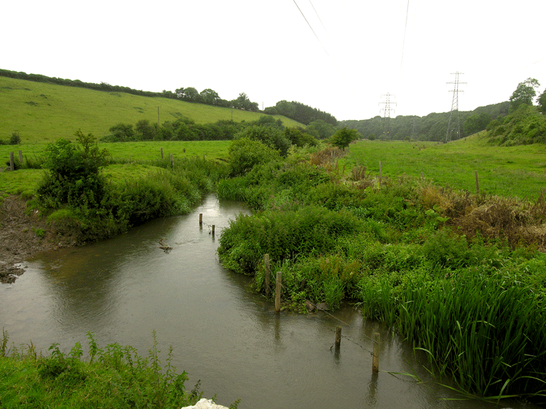
The historic landscape area of Kenson River Valley represents an area of land bounded to the north by the Kenson Bridge, below the confluence of the Nant Llancarfan with the River Waycock, and to the south by the B4265 Road. The remainder of the area is defined by the plateau edges above the river valley itself where ancient replanted and ancient semi-natural woodland dominate the valley slope. An area of undeveloped meadowland, the river valley forms the main flood zone for the River Kenson. The area remains largely unenclosed though there has been some superficial subdivision. The area is located within the parishes of Llancarfan and Rhoose, the former to the north of the Kenson River and the latter to the south, and formed part of the Early-medieval cantref of Penychan and the later Hundred of Dinas Powys.
Little is specifically known of the area's early history, being part of the hamlet of Llancadle. Just outside the area to the north, a number of cropmarks (NPRN 89367, 89368, 89369, 89370, and 89371) of possible prehistoric date, identified from aerial photographs by the Royal Commission as possible fortified farmsteads or enclosures (RCHAMW 1995). The location of the valley of the River Kenson is likely to have had a strong influence on the siting of these prehistoric settlements and their operation in an economy likely based on some form of pastoral transhumance, with the river and tributary streams providing a major water source. The nearby post-medieval settlement of Llancadle, its precursor the medieval grange and deserted medieval settlement are likely to have maintained a similar relationship.
The area is predominantly used for grazing of animals; a cattle route runs through the area (03439s) extending downhill, presumably towards the river, though no exact date has been assigned to this feature it seems likely to have had at least medieval origins if not earlier.
The area includes the remains of a relict agricultural landscape on the hillslope to the south of Kenson River in the form of a series of lynchets (03440s) running downslope and aligned north to south, these were probably associated with the nearby settlement of Penmark to the south.
Historic Landscape Characteristics
Kenson River Valley, an area today characterised by its geography, a flat-bottomed valley forming a narrow river terrace or floodplain either side of the River Kenson. This area exists as semi-improved meadowland with ancient replanted and ancient semi-natural woodland. A further key characteristic of the area is its open nature the predominant field boundaries here are drainage ditches. The area is depicted on the manorial map of Lancadel (Llancadle): 1622, as being divided into linear meadows including 'the Lord's Mead' and 'Kensom Meadow', and the 'Towns Meade'; the latter further sub-divided into narrow strips or quillets of interspersed copyholders, the strips aligned east-west and stretching between the settlement of Llancadle and the River Kenson. These linear strips occasionally survive, preserved by relict earthwork boundary features, or lynchets.
A number of lynchets (PRN 03440s) also exist on the slopes south of the river at the east of the area near Kenson Bridge, visible in aerial photographs running downslope on a north-south alignment, focussed on the adjacent settlement of Penmark, just south of the bounds of the historic landscape.
No settlement survives in the area today; however the manorial map of 1622 shows a single dwelling immediately south of the track leading to Kenson Bridge; this survives to be depicted on the 1st edition OS map of 1879 within a rectilinear enclosure, though the enclosure survives until the 3rd edition OS map, the dwelling has been demolished by the survey of the 2nd edition. Features relating to this early post-medieval structure may survive in a relict or buried state.
The relationship between this character area and other surrounding settlements such as Penmark and Llancadle is likely to have continued throughout the areas history, as these surrounding settlements also needed to maintain a connection with a substantial water supply. The Kenson River and its valley area are likely to have served the deserted medieval settlement at Llancadle, the former monastic grange at Llancadle and its post-medieval agricultural replacement, and continue to be an important resource for livestock in the area.
The area forms a natural grazing and animal-watering area, and is likely to have witnessed use for this purpose since at least prehistoric times when the cropmark features (fortified settlements or enclosures) within the adjacent character area (HLCA 005) are likely to have been occupied. The area today is still used predominantly for the grazing of cattle and a surviving cattle trail (PRN 03439s) runs downhill though the area towards the river from the southeast.
Additionally minor communication/transport links add to the character of the area, specifically existing here as bridges, footpaths and track ways.