Llancarfan
001 Llancarfan
HLCA 001 Llancarfan
Nucleated post-medieval settlement (of medieval origin); medieval/post-medieval buildings; traditional boundaries; Ancient and other broadleaf woodland; evolved/irregular field pattern; relict and buried archaeology; agri-industrial features; communication; ecclesiastical features; historic association. Back to Map
Historic Background
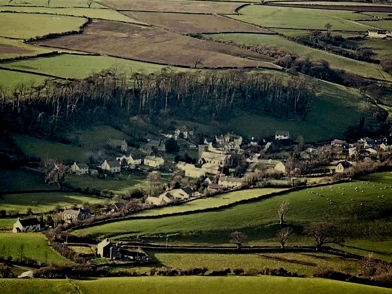
The historic landscape area of Llancarfan is an area of established nucleated settlement comprising the main settlement focus of Llancarfan, and a settlement with important Early-medieval monastic associations. Enclosed within the steep-sided wooded valley of the Nant Carfan, or Nant Llancarfan, the area is bounded to the west by the dense ancient woodland of Coed-y-Crinallt, and to the south and north by pasture and arable fields. The area encompasses the main settlement of Llancarfan including the valley sides and land to the south of the area identified as glebe land on the tithe map of 1840. The area is largely commensurate with that of the Llancarfan Conservation Area, apart from the omission of a small area of agricultural land to the north, placed within HLCA008.
The exact origins of name of the settlement of Llancarfan have been debated elsewhere; however the name is definitely related to the Early-medieval monastery established at the site in the 5th or 6th century AD. An abbot of Llancarfan, variously Nant Carban, Llan Gharban (PRN 00384s) first is mentioned in a charter of 7th century date Iacob abbas altaris Sancti Catoci (LL144 of c650), and subsequently in a charter of the 10th century simul cum dignitae pontificalis cathedrae abbati totius dignitatis ecclesiae Sancti Catoci Lann Caruaniae (LL243 of c980) (Davies 1978, 135; 1979, 97, 125). A 'Lann Gharban' is mentioned in the 9th-10th century Irish Lives of St Finnian implying a monastic settlement. The monastery, an early Celtic monastery or a greater clas, is attributed to either St Germanus in the 5th century, Dubricius in the late 6th century, or, more generally accepted, St Cadoc/Cattwg, son of Gwynllyw, a contemporary of Dubricius, about AD 500; the last is given (as Landcaruan/Nant Caruguan) by Lifris's Vita Sancti Cadoci (Life of St Cadoc) of c.1100 (Wade-Evans 1944, xi, 52-5). Its location has been debated, at either Llanvithyn, or at Llancarfan. Evans in 1944 believed it may have been on the site of the present church at Llancarfan (PRN 385s). Located within the church is a late 9th or 10th century pillar cross, to which has been added an inscription of probably 11th or 12th century date (PRN 780s; RCAHMW 1976, 62 no 940). According to the Lives of the British Saints (Baring-Gould & Fisher 1907-13) the early monastery lay to the south, in a field called 'The Calvary' or 'Culvary'. The 1st ed OS map of 1885 also records this field as the site of the monastery. A small excavation was carried out here in 1964, which revealed a substantial mortared foundation wall aligned north-south, with occupation soil and 13th - 14th century pottery, and a debris layer of Pennant Sandstone roofing tiles containing broken serrated green glazed ridge tiles of 14th century type. Other associated evidence has been revealed by the erosion of a stream bordering the field to the east. The area has now been scheduled, however, the RCAHMW rejects this site as the site of the Early-medieval monastic settlement on the grounds that there is no specific evidence, archaeological or otherwise, and favours the unusually large churchyard (PRN 03736s) of the parish church as the monastic enclosure of Lann Gharban (PRN 384s; RCAHMW 1976, 17 no 827). The large churchyard is shown on the tithe map of 1840 (GlRO/36/7) as irregular with a rounded SW corner, and as at Llantwit Major is partly bounded by a stream (Evans 1998).
First mention is made of the current building of Llancarfan church (Listed Building Grade I; PRN 00385s) in 1106 (Green 1907, 68), when the tithes of Llancarfan were transferred to Tewksbury Abbey. Prior to this the old monastic class had been given to the church of St Peter at Gloucester, through a grant made by Fitzhammon between 1091 and 1104. Documentary sources appear to support some level of restoration of the church at Llancarfan during the mid-12th century, whilst the earliest surviving datable feature, the Transitional chancel arch, has been dated by Newman to c. 1200 on the basis of the carving on the impost bands (Newman 1995, 374). Documentary evidence indicates repair to the chancel was carried between 1284 and 1307, and this probably relates to the 13th and 14th century fabric in the church (Evans 1998; Orrin 1988b, 181). The church was repaired again in 1877-8, with extensive work carried on the tower then or slightly later in 1890.
No trace remains of St Margaret's Chapel (PRN 01850s) formerly located 'at the end of St Margaret's Bridge over the River Carven' and described as ruinous in Lhuyd's Parochalia (Arch Camb 1911, pt 3, 22). Two other features of medieval or post-medieval date associated with Llancarfan Church which also have not survived, include the church house (PRN 03564s), later used as a school, and Llancarfan tithe barn (PRN 03565s/01402s), both described in 1901; the church house was of 2 storeys with external stair, whilst the latter building had a plain doorway, with three cruciform oeillets in the north wall and a further one in the gable above.
At the south east edge of the village four lynchets (PRN 01417s) have been identified aligned north-south along the slope from which Medieval potsherds were recovered indicating that the land here was ploughed and manured during that period.
The main land owners by the mid 19th century were Sir Thomas Aubrey, the dean and chapter of Gloucester, though several others also retained an interest in the village including Charles Kemys Tynte and the Rev William Lisle and Meackham Berkin, for example.
There is little difference in the layout of Llancarfan between the tithe map of 1840 and the 1st edition OS map of 1878/79, apart from minor additions and losses, such as the loss of the tithe barn in the southwest corner of the church yard and the removal of the north and south transepts of the church itself. Two distinct cores are visible, one centred on the church, the other on Cross Green, and the Old Corn Mill. The road layout is essentially a main north-south lane on the west side of the Nant Carfan, or Nant Llancarfan valley from Bonvilston in the north, via Greendown to Painscross and the south. A number of general east-west routes (on the 1st edition map) join the main valley route here with routes leading to/from Moulton and Walterston (Trewallter), and a track to Garnllwyd to the northeast. These routes cross the stream of Nant Llancarfan (also Nant Carfan) at three places; two crossing points at Cross Green, the northern one a footbridge only, that to the south a ford and foot bridge, and a further at the main part of the village just southeast of the church; here a road bridge and foot bridge span the stream at a former fording point. A further north-south lane, with a small croft indicated on the tithe and 1st edition OS (now Bwthyn Gwyn) on the east side of the valley links the roads to Moulton and Walterston, whilst east of the southern river crossing point a lane leads south to Pen-onn and beyond.
The main part of the village is located around the irregular ovoid churchyard bounded by the Nant Llancarfan to the east and lanes to the west and south. The churchyard is shown on the 1st edition OS map (1878/79) with the now demolished poorhouse located at its southern boundary wall. The main village comprised the 18th century Fox & Hounds public house, a linear range of buildings north of the churchyard, set immediately fronting the lane to Painscross (the Fox and Hounds has a triangular garden plot to the rear the eastern boundary defined by Nant Llancarfan). Opposite on the west side of the lane, a linear ribbon development of cottages (most of which are now either demolished or enlarged) extends northward and southwards from a post office (Brook Cottage) and the early 19th century Wesleyan Methodist Chapel and burial ground south to the 19th century Bethlehem Baptist Chapel, built 1823 and rebuilt in 1870, with its burial ground and adjacent smithy, with Hillside beyond, the latter noted as having a fireplace stair. Opposite Hillside to the east of the lane is Corner House and to the south, Great House and Fern Cottage, beyond. At Bethlehem Chapel, an east-west aligned lane passes the southern boundary of the churchyard running to a crossing point on the Nant Llancarfan. On the southern side of and fronting the lane just east of Corner House and opposite the, now demolished, poorhouse, is a linear range of terraced cottages (now altered and partly truncated) a further building (now demolished) is shown immediately to the east, with its gable end set towards the lane. Heading east across the stream on the north side of the lane is the School (Boys and Girls) built in 1875; this is the current Llancarfan County Primary School. Further south on the edge of the settlement east of the stream are a number of other buildings in place before 1879 including the Old Parsonage and the two parallel ranges of the 'New mill' at the southern end of a crescent-shaped millpond.
It is noticeable that a number of the older houses in the village are set tangentially to the lanes, that is with their gable ends facing the road, for example Great House, Fern Cottage, Bwthyn Gwyn, and Brook Cottage, among others, all shown or named on the tithe map of 1840. This arrangement may reflect the linear arrangement of the crofts or land holdings on which they were erected, or the older vernacular tradition of siting buildings tangentially to the slope, i.e. built into the hillside, a development in part related to the long-house tradition with obvious benefits to shelter and drainage.
Cross Green, separate and slightly to the north, and probably named after the junction of several lanes and tracks, at this date appears as an open area with the old corn mill, and a cluster of cottages within a matrix of irregular enclosures; Crossgreen and Green Cottage, and slightly to the west, over a ford (with adjacent foot bridge) across the Nant Llancarfan Brook, Caradoc Cottage and the slightly larger Ty-to-maen (now demolished), the name probably indicating a house of some importance, distinguished by its stone roof, or 'to-maen', an expensive roofing material in an area where thatch would have been the characteristic roofing material until at least the mid-19th century. The name could also imply a building of 17th century or earlier date.
Subsequent OS maps chart further minor changes to the fabric of the settlement: for example Ty-to-maen has been reduced in length (or replaced with a smaller structure), while a new house of the same name has been constructed to the north west on a new site, the poorhouse adjacent to the church demolished, additions to the north side of the Wesleyan Chapel, and further building has been erected to the south of Fern Cottage by the publication of 2nd edition OS map in 1900. By 1919 (third edition OS map) the present village hall (named Church Room) had been constructed on the southern boundary of the churchyard, and further peripheral development had occurred in the form of a U-shaped agricultural range at Ty-to-maen (north of the original house), and at the southern edge of the village the addition of 'New House'. There has been further semi-suburban style infilling during the twentieth century mainly in the area northeast of the churchyard, Cross Green, and at the southern edge of the village, though this has been of a scale and nature that so far has not greatly altered the visible historic character of the settlement.
Historic Landscape Characteristics
Llancarfan is characterised as a post-medieval nucleated organic settlement or village, with Early-medieval origins. Originally the settlement effectively had two foci; one based on the medieval church and churchyard of Llancarfan, the other on a former 'village green', Cross Green, formerly an open area of land at a road junction and river crossing, and the earlier location of the village corn mill. The latter area, which developed as a clustered settlement around the mill, has subsequently coalesced with the main settlement around the church with ribbon development along the main north-south road through the settlement, augmented by more recent piecemeal housing development in the area between the older core settlement clusters around the church and former corn mill and green.
The varied and mixed building type of the area mirrors the organic nature and development of the settlement and includes detached houses, cottages, terraced cottages, places of worship and mills. The principal building materials noted in the area include stone, both random and coursed, and brick, whilst roofing materials: slate, tile and concrete tile have completely replaced the traditional thatch, which occasionally survives in the surrounding region.
Perhaps the most visually dominant of the area's building stock, apart from the medieval St Cadoc's Parish Church, is the nearby Fox and Hounds Inn (PRN 01418s). Although altered this building retains considerable historic character; it comprises a range of 18th century 2-storey buildings with rendered walls, under a slate roof, end gables, stone stacks, windows typically 2 light wooden casements (first floor) with glazing bars and a square-headed panelled door. Other characteristic buildings include Hillside (PRN 01624s), a much altered cottage (e.g. door way to street altered to window, steps remaining) possibly of 18th century date or earlier with fireplace stairs, rendered walls with steeply pitched slate roof with single gable stack in brick surviving, 19th/20th century sash windows. Corner House (PRN 01422s), a 19th century cottage with a symmetrical facade, has recently been extensively altered; described as having small paned wooden windows (now replaced in UPVC), central porch, and two stacks and being cement-rendered and colour-washed. This cottage used to have a thatched roof, which like many in the Vale has been replaced with slate. Chapel House or Cottage (associated with Bethlehem Chapel to the south) is a traditional building also of 19th century date with early additions to the west and east ends. This double-fronted building is also cement rendered, with a slate roof, gable stacks, and having wooden casement windows.
A number of the older houses in the village are characteristically set at a tangent to the lane, or aligned end onto the road, for example Great House (18th century or earlier, stone built slate roof, cement-rendered elevations, and replacement fenestration), Fern Cottage, Bwthyn Gwyn, and Brook Cottage, Chapel House, among others. As mentioned above, this arrangement could reflect the linear arrangement of the crofts or land holdings on which they were erected, or may simply relate to the older vernacular tradition of siting buildings tangentially to the slope; a development in part related to the long-house tradition with obvious benefits to shelter and drainage.
Other characteristic features include a listed telephone call box (LB Grade II; PRN 02158s) located between the parish hall and the bridge; a square, red kiosk of cast iron construction to the standard design of Giles Gilbert Scott of London introduced by the GPO in 1936, and the early 20th century parish or village hall, a building with rendered walls (pebble-dashed) with plain yellow brick quoins and detailing around window and door openings and half-hipped roof. The modern housing stock consists largely of substantial detached properties of rendered brick within their own plots.
The Nant Llancarfan runs through the village and is an important feature, water supply, and also the harnessing of waterpower for milling is therefore also a characteristic of the area. The characteristic of rural industrial archaeology is represented by the buildings and mill race systems associated with Old Mill at Cross Green, and New Mill, at the south of the village. The former, indicated as the corn mill on the tithe and 1st edition OS, has been converted into a dwelling, though retains its mill wheel. The village formerly had a smithy, or rural blacksmith's workshop, characteristic rural 'industrial' or craft features of settlements prior to the mid 20th century.
Mortared stonewalls, such as that surrounding the churchyard, form a characteristic feature within the settlement, some examples have been rendered (e.g. leading to Fern Cottage). Examples of other traditional boundaries also occur, such as stone-faced banks with hedges, hedges, and ditches, reflecting the nature of the wider agricultural landscape. The settlement fringes have expanded into the surrounding irregular fieldscape, which retains both relict and buried evidence of medieval agricultural practice in the form of lynchets and it is possible that the surviving boundaries at least in part originated in the medieval period.
The area's relict archaeology is essentially related to the medieval settlement and associated agricultural landscape, evidenced by lynchets and finds of 13th/14th century pottery, a settlement centred on its medieval church (and irregular-shaped churchyard, of Early-medieval origin, and provides an important ecclesiastical characteristic. Whilst the external appearance of the church of St Cadoc is largely of 13th, 14th and 15th century date, showing decorated and perpendicular styles, evidence survives to suggest 12th century construction, whilst a carved stone monument and the churchyard topography indicate pre-Norman origin. The shape of the churchyard also appears to have had a long lasting influence on the settlement layout; the road layout defines an area of land, now partly built over, immediately to the east of the churchyard and Nant Llancarfan, which appears to be a natural extension of the churchyard at least in form.
Significant buried archaeology includes an irregular oval mound (now scheduled) in an area to the south of churchyard known as 'Culvery' or 'Calvary Park', which was excavated in 1964. The excavations revealed a substantial north-south aligned mortared foundation wall in association with 13th and 14th century pottery, debris layer sandstone roofing tile with green glazed ridge tile of 14th century type (PRN384s; SAM GM075; RCAHMW 1982). The exact association or purpose of these structural remains is unconfirmed; the evidence indicates a structure or building, associated with high status building debris (either secular or ecclesiastical) of 13th century date at the earliest; whilst the place name evidence would suggest the site might have some sort of ecclesiastic association, it cannot be definitely claimed that this was the site of the Early-medieval monastic site of Llancarfan, as opposed to the churchyard itself.
The area's ecclesiastic characteristic is visibly represented by its impressive medieval parish church, in 1801 the largest in the County; restored in the Victorian period, the church consists of a nave, separate chancel, a south aisle (including the Raglan Chapel) of the same width as the nave, a south porch, and a rather squat crenellated west tower. The church had an unusually wide rood loft; the associated rood screens survive as a significant internal feature. Much of the south side of the building is covered in traditional limewash, here mostly applied over render, but where the masonry can be seen it is constructed of coursed rubble in the local lias limestone. Sutton stone was used for the Decorated windows and sandstone for the other openings and for the arcades. The earliest surviving datable feature is the Transitional chancel arch, which Newman dates to c1200 on the basis of the carving on the impost bands. The nave arcade and the door between nave and porch are both Early English, of either mid-13th or 14th century date. Repairs to the chancel, and tower, including refenestration, appear to date from the same period (Evans 1998, 16-17; Newman 1995, 374; Orrin 1988b).
Non-conformist chapels, both shown on the 1st ed OS map of 1885 and tithe of 1840, enhance the ecclesiastic characteristic of the village. White Chapel (PRN 01419s) is an early 19th century Wesleyan Chapel, now converted into private dwelling; this whitewashed chapel with rendered walls, lancet windows (intersecting tracery style glazing bars) and slate roof projecting eaves and added two-storey projecting entrance crosswing at its north end with entrance having arched window light above, occupies a prominent site set back from road. To the south Bethlehem Chapel (PRN 1421s) is a 19th century chapel with an interesting front gable elevation, other elevations plain; the entrance façade has a round headed-doorway with segmented ashlar surround, name and date plaque above and to either side round-headed windows, projecting moulded cornice and shaped pediment above.
Continuing at least a ritual, rather than ecclesiastic theme is Llancarfan Holy well (PRN 01849s) just outside the village, a 'pin and rag well' said to cure King's Evil (scrofula); pieces of material from underclothing were hung on bushes after drinking at the well. This well is noted by Jones to be primarily reputed in tradition as a healing well, rather than belonging to a class of well associated with saints or churches (Jones 1954, 186-7).
The area has a number of characteristic communication features including tracks, lanes both straight and winding, defined by natural topography and the earlier enclosure boundaries in the settlement, in particular that of the irregular-shaped Early-medieval churchyard. The Nant Llancarfan has been crossed at first by means of fording places and later by foot and road bridges, a road bridge and ford both exist in the village, as minor but characteristic features.
Both the topography and the wooded nature of the settlement's environs contribute to a very enclosed feeling; the area's Ancient woodland located on the steep slopes, notably to the west of the village, along with areas of other broadleafed woodland within the settlement itself are an important and visible characteristic. This aspect also acts to hide much of the later housing development, making the settlement appear less altered by later additions.
The village and the surrounding area has important historic associations with several people, starting with the Early-medieval saints, St Cadoc (Cadog) and St Germanus, Caradog the historian referred to by Geoffrey of Monmouth in his Historia, and author of the Life of Cadog and the Life of Gildas, and possibly the Vita Cungari, is considered also to have had a possible association with the Book of Llandaff. Also strongly associated with Llancarfan is the bard Iolo Morgannwg, born at nearby Pen-onn in 1746 and noted for his imaginative interpretation of history including the fabrication of several chronicles, such as the Brut Aberpergwm and the Brut Ieuan Brechfa (Lewis 1971, 449-554).