Llancarfan
004 Llancadle
HLCA 004 Llancadle
Post-medieval settlement: clustered (later ribbon development); post-medieval buildings; relict and buried medieval settlement and agricultural features; ecclesiastical associations. Back to Map
Historic Background
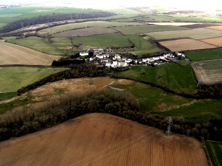
The historic landscape area of Llancadle represents an area of settlement bounded by large amalgamated fields to the north and west and by the Kenson river valley to the south and east; largely defined by the extent of current and former agricultural settlement. The area comprises the hamlet Llancadle within Llancarfan parish and the associated crofts immediately adjacent to the settlement. Also included is a large gently sloping field to the southwest of the modern day hamlet, named Bull Close on the tithe of 1840, this area contains a number of well-preserved earthworks associated with Llancadle deserted medieval settlement (PRN 00691s, 02428s, NPRN 15340, 15341, SAM GM534). The area encompasses the Llancadle settlement Conservation Area as identified in the UDP (Vale of Glamorgan Council 2006).
The earliest evidence of occupation dates back to the medieval period attested by the presence of relict medieval features and associated land holdings. During the medieval period, settlement in the character area comprised a small hamlet to the south of the present settlement. The remains this medieval settlement (PRN 00619s, 02428s, NPRN 15340, 15341, SAM GM534) can be seen to the southwest of the present day hamlet of Llancadle. The settlement survives as well preserved earthworks that define a series of enclosures or crofts, some of which contain house platforms where dwellings would have stood. The enclosures are arranged along a sunken track way/hollow way (PRN 00691s; RCAHMW 1982, 223-4). The condition of these earthworks may mean that any associated archaeological deposits survive in a well-preserved and relatively undisturbed state. This area and the shrunken medieval settlement as it survived by the early post-medieval period are depicted on a manorial map of 1622.
Llancadle has been tentatively associated with Lan Hoitlan, an Early-medieval church site of unknown location; first mentioned in the charters attached to the Life of St Cadoc, as a pre-existing Early-medieval institution, Lan Hoitlon is noted as having been given to St Cadoc by Catlon. Wade-Evans considered that Catlon may be associated with the placename Talcatlan=Llancadle, and if so, Lan Hoitlon may be the site of Llancadle Chapel (Wade-Evans 1932, 153-4 no.3), this however has been rejected completely by other authorities (Pierce 1968, 86).
The physical remains of a chapel at Llancadle, now demolished, considered to date to the 14th century are mentioned in the 1970s County Treasures Survey (South Glamorgan County Council 1970); the chapel (formerly listed as grade II LB 13604) is depicted on the 1879 1st edition OS map, and other sources (PRN 00496s; South Glamorgan County Council 1970) state that the chapel was used as a cottage, as indicated by the Llancarfan tithe of 1840, which records the area as a Cottage and Garden, occupied by William Rees and Thomas Evan and owned by Robert Oliver Jones. Though this building was demolished in 1969 to make way for housing (PRN 00496s), it is possible that below ground remains may survive.
The area once formed part of that land given to the dean and chapter of Gloucester and is shown as such on the tithe, the area is also recorded as owned by one Robert Oliver Jones. The tithe also shows Llancadle's surrounding fieldscape largely the same form as it appears today, irregular but generally large enclosed fields, this demonstrates that the process of enclosure happened before production of the tithe in 1840: indeed the manorial map of 1622 indicates the process of field amalgamation was underway by the early post-medieval period, though the medieval openfield of strip fields or quillets is still predominant at this stage.
Comparison of the modern OS landline mapping, and the available historic maps indicates there has been a great deal of change and addition to the settlement's building stock over the years. Apart from the Llancadle Farmhouse, Lower Llancadle Farm and the Green Dragon Public House, all extant on the 17th manorial map, the majority of the dwellings depicted on the historic mapping no longer appear to survive, though detailed survey is needed to confirm this.
Historic Landscape Characteristics
Llancadle is characterised today as a clustered, unplanned settlement, with recent ribbon development and infilling. The settlement layout can be demonstrated to be largely similar to that extant in the 17th century, which in turn is the shrunken remains of a more extensive medieval settlement. The remains of the deserted medieval settlement (SAM GM534, NPRN 15341, PRN 00691s, 02428s), also contribute to the overall historic character of Llancadle. The remains of a now deserted medieval village in the southern part of the character area survive as relatively well-preserved earthworks, and parchmarks representing a series of enclosures or crofts, with associated house platforms, and a hollow way. The tithe map shows the area of the deserted settlement as a single elliptical enclosure named Bull Close, whilst the manorial map of 1622 shows several closes within the area: Westerclose, the Trench and the Acre, among others, and a hollow way running south east from Marsh Way (the southern extent of Lancadle Street) to the sharelands of Townsmeade within the Kenson Valley to the east. Two closely arranged small rectangular crofts are also visible near the southeastern extent of the hollow way, which is shown doglegging between them.
The current settlement at Llancadle comprises a ribbon of houses set along the main road and a cluster of buildings around the junction of this main road with the Llancadle farm access road, which is appears to have formed the main axis of the settlement during the early 17th century and probably also during the medieval period. The main focus of the settlement today is around Llancadle Farm and the nearby crossroads. The manorial map of 1622 depicts Llancadle village as a clustered settlement at the junction of lanes leading to the agricultural hinterland, with habitations set at the edge of small crofts and an area of openfield to the north divided into partially enclosed narrow strips. The settlement at this date is a cluster of 13 farmsteads arranged around and within a slightly sub-triangular plot with an irregular yard to the northwest from which the 'Plashed Waye', an agricultural track, depicted on the 3rd edition OS map, extended west to the meads and meadows along the Thaw Valley; and still survives. The focus of the settlement was the former chapel of ease of Llancadle, by this date converted into a farmhouse (the remains of which were finally demolished during the 20th century). 'Llancadle Streete', the main route to Llancarfan, via Middlecross and Pancross passes through the lower western part of the settlement. It is noticeable that the general layout of the current settlement largely reflects that of the early post-medieval layout, though with few of the original houses surviving and the additional infilling of ribbon development north along the road to Middlecross.
The hamlet of Llancadle now appears to be dominated by dwellings of late 20th century date; however older buildings do survive and these retain much of their original character; usually rendered and lime washed with surviving brick and stone chimney stacks. Characteristic remains of the early 17th century settlement are the houses of Lower Llancadle and the Green Dragon public house both depicted on the manorial map of 1622 and detailed on the 1879 1st edition OS and later maps; these are characteristically rectilinear ranges, with outshuts to the rear. Of the surviving early structures within the settlement the only structure described in any detail, apart from the now demolished chapel, is the Green Dragon Public House; this, was previously recorded as a small, whitewashed gabled-entry house of 17th Century date with later additions under a thatched roof with 'eyebrow' over attic window, whilst internally the hall had a beamed ceiling and winding stair. The building has been extensively remodelled externally, loosing its thatched roof, and has been extended.
Between the Green Dragon and Lower Llancadle recent 20th century housing has replaced a number of cottages located closer to the lane. The present building of Lancadle farm house towards the west of the settlement, a large rectangular structure, stands within the same footprint occupied by that shown on the 1st edition OS map, possibly that depicted on the manorial map of 1622. Nearby to the north stands a large U-shaped range of agricultural buildings, and a number of detached structures dating to the latter half of the 19th century. These replace a clustered arrangement of out buildings depicted on the tithe map of 1841, one of these structures appears to survive, an outbuilding (NPRN 37,579), which may be also one of the agricultural buildings (i.e. those without chimneys) shown on the manorial map of 1622. Mortared walls are the predominant characteristic boundary type within the settlement, though towards the edges hedge boundaries exist.
The area also has long standing ecclesiastical associations; an Early-medieval church is conjectured to have existed at Llancadle associated with the monastery at Llancarfan (PRN 00496s; South Glamorgan County Council 1970, OS card ST 06 NW 16). Other ecclesiastic associations exist such as the site of the now demolished 14th century chapel of ease and the fact that lands in the area were granted to the Abbey of St Peter at Gloucester.
In addition the relationship of this character area with the surrounding landscape, both within and beyond the boundaries of the historic landscape, is of importance given the wealth of documentary evidence showing the landscapes previous form and subsequent development from one dominated by remains of the medieval openfield system during the early 17th century to one largely enclosed and with amalgamated fields by the mid-19th century.