Llancarfan
008 Middle Llancarfan Valley: Llanvithyn and Garnllwyd
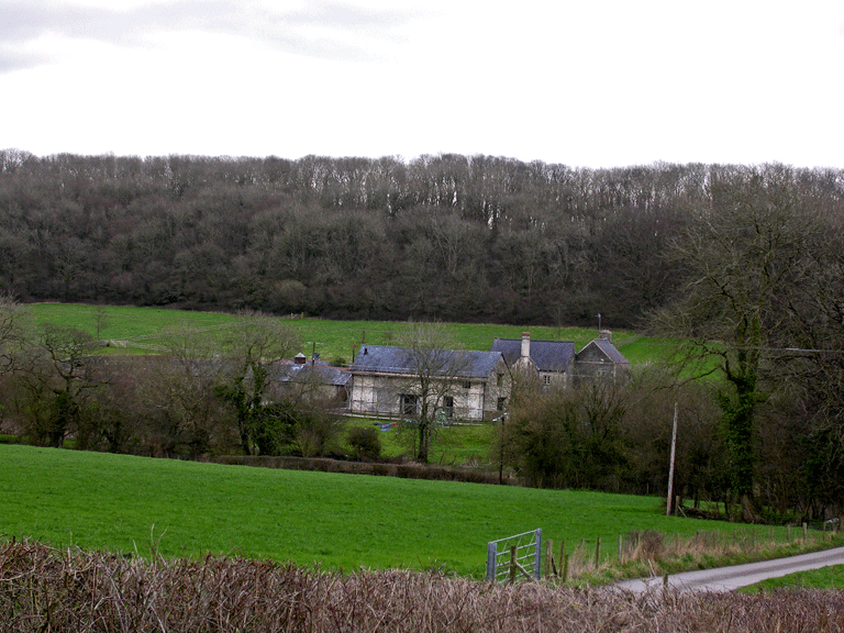
HLCA 008 Middle Llancarfan Valley: Llanvithyn and Garnllwyd
Medieval/post medieval field system (evolved/irregular fieldscape); traditional boundaries; dispersed post-medieval settlement; post-medieval/medieval buildings; relict and buried archaeology; agri-industrial features; Ancient and other broadleafed woodland; medieval ecclesiastic characteristic; historic association; communication; resources. Back to Map
Historic Background
The historic landscape area Middle Llancarfan Valley: Llanvithyn and Garnllwyd is a largely post-medieval agricultural landscape with some agri-industrial characteristic features e.g. quarries and limekilns. This area takes in the former parish and manor/grange of Llanvithyn with its mills, and extends east to take in the Manor of Garnllwyd an area, which belongs largely to the hamlet of Llancarfan.
This area comprises the river terrace and steep, partially wooded valley sides of the central valley area of Nant Llancarfan, north of the core area of Llancarfan. The area includes substantial blocks of ancient semi-natural woodland and other broadleafed woodland chiefly on the steepest slopes, such as Coed Garn-llwyd. The area is largely set down to grazing and grass crop. A slightly irregular field pattern of varied medium fields survives with areas of amalgamated fields to the south of Llanvithyn House and north and east of Garnllwyd Farm, probably relating to late 20th century agricultural improvements.
Occupation of the area dates from the prehistoric period, attested to by a Bronze Age standing stone, the 'Druidstone' (PRN 03813s), with the earliest settlement feature (also 'defensive' in nature), the defended enclosure or hillfort of Llanfythin Camp also (SAM GM293; PRN 00397s), which retains the ploughed remains of two stone and earth ramparts with outer ditches. Without excavation it is not possible to establish whether occupation of this site continued into the Roman period. It is also possible that the site was even occupied, or at least re-occupied during the Early-medieval period.
During the medieval period settlement clusters or hamlets would have been a more dominant characteristic of the landscape; this is currently reflected by relict features associated with the deserted settlement centred on Llanvithyn, that of Bradington. Other relict features may be associated with the monastic grange at Llanvithyn associated with Margam, whilst it is also likely that further settlement features may also be identified in the area near Garnllwyd, a manorial focus during the medieval period. Relict archaeological features include the remains of a field system and track ways at Llanvithyn (the site of medieval Bradington).
Based on the existence of a chapel of St Meuthin at Llanvithyn, in the parish of Llancarfan, there is a tradition that identifies Llanvithyn as that of the early monastery of Llancarfan (St Meuthin, otherwise known as St Tatheus, having been St Cadoc's teacher), and a possible subsidiary centre to the main focus at Llancarfan (Knight 1984, 377). Llanvithyn was later granted to Cistercian Abbey at Margam, which established a grange here (Williams 2001, 306 no.101), which was gradually enlarged at the expense of its lay neighbours. A grant of land about 1190 to enlarge the grange refers to an 'old churchyard' there, and five burials were discovered in the late 1960s at Llanvithyn House, obviously part of a cemetery of 'many scores of coffinless inhumations' previously recorded on the site. It had been considered that this cemetery belonged to a pre-Norman phase (Lewis and Knight 1973), though doubt has been cast on early origins of the cemetery, as burial is also a noted feature of later, medieval grange sites (Williams 2001, 197).
The most extensive area of earthworks to the east of Llanvithyn House, relate to the deserted village of Bradington, which was depopulated when the grange was enlarged (RCAHMW 1982, 229), but the area's earthworks also include a curvilinear bank to the south, roughly concentric with the cemetery site, which RCAHMW (1982, 292) identify as the grange boundary. The potential for an Early-medieval origin for this boundary has been argued against (Evans 2004, 65). Evans also notes that whilst documentary evidence exists for the grange chapel (dedicated to St Meuthin) having been built on a plot of land especially donated for the purpose (RCAHMW 1982, 291), no evidence exists for a pre-existing church. The known burials all come from the area of the chapel and were therefore presumably related to it rather than to 'the old cemetery'. If Llanvithyn was an Early-medieval ecclesiastical site (perhaps an undeveloped cemetery site related to the curvilinear boundary, noted by the RCAHMW), it would appear that the medieval village may have been established over at least part of it before being removed to make way for the later grange, but it is unlikely that this problem will be resolved in the absence of excavation. In addition recent field survey work undertaken as part of a Cadw-sponsored Early-medieval ecclesiastic project did not produce any evidence for features of Early-medieval period, and also failed to note the curvilinear bank surveyed by RCAHMW as the boundary of the grange (Evans 2004, 65).
The successor to the medieval grange at Llanvithyn associated with Margam Abbey was the largely post-medieval Llanvithyn House, also known as Monkton. After the dissolution of Margam abbey in 1536, Llanvithyn was leased to the Sir John Raglan of Garnllwyd and in 1545 Sir Edward Carne purchased the property from the Crown. The house and land subsequently passed to Thomas Carne of Ewenny. In 1565 William Griffith, a noted Catholic recusant, and his father Hugh, purchased the former grange for £300. The house later passed into the hands of the Bassett family who built the gatehouse to the front of the property in 1636. In 1679 Thomas Bassett sold it to Sir Richard Bassett of Beaupre. After his death in 1707 it was bought by Robert Jones of Fonmon. In the 19th century the house and farm passed into the ownership of the Ecclesiastical Commissioners.
The medieval manor house at Garnllwyd (PRN 00388s; LB 13,592 grade II*) was first recorded in 1441 as Carne Lloide, when the possible builder, Lewis Mathew, was in possession. At this date the site comprised a medieval first-floor hall, subsequent owners extended and altered the property. The manor house and estate passed to the Raglan family through marriage and remained in that family until c.1600, when dispossessed, the house falling into the hands of Sir John Wildgose of Eridge, Sussex and subsequently sold in about 1620 along with other property in Llancarfan to Sir Edward Lewis (d.1628) of Y Fan. Following the death of Edward Lewis in 1674, ownership passed to the Aubreys of Llantrithyd Place by his sister's second marriage, and was held by them in the mid-19th century.
Milling associated with the monastic grange of Llanvithyn is first recorded in medieval documents, which recorded that in 1336 the 2 mills at Llanvithyn were worth 2 pounds. The same mills were leased to Sir John Raglan on 10 June 1519 in a general lease of the grange.
Historic Landscape Characteristics
Middle Llancarfan Valley: Llanvithyn and Garnllwyd is characterised as an evolved/irregular fieldscape (including some medieval strip fields) with characteristic field boundaries: stone-faced bank with hedge, hedges, distinctive hedgerow trees, mortared walls around settlement, augmented by post and wire fences.
Whilst there is some evidence of potential medieval fields fossilised in the post-medieval boundaries, there is little evidence on the tithe to suggest dispersed openfield strips, apart from the area around Gowlog, where dispersed holdings survive. By the mid-19th century the process of holding amalgamation appears more or less complete with discrete blocks of land/holdings centred on the dispersed farmsteads, still characteristic of the landscape. It is notable that these holdings cover a range of land types including agricultural plateau, valley side and river terrace.
By the post-medieval period (before the late 18th century) settlement is typified by dispersed farmsteads, and small agricultural clusters typically of outbuildings, farm cottages and mills. The main farms/holdings by the 19th century comprise Llanvithyn Farm, Garnllwyd, and Caemaen farm, with lesser holdings at the fringes, such as Gowlog and Abernant Farm. The main landowners within the HLCA by the mid-19th century were Sir Thomas Aubrey Digby, the Rev William Lysle, and Charles Spencer Richard.
The area is also characterised by a pattern of typically dispersed post-medieval agricultural settlement, chiefly farms but also associated cottages and mills, with clusters at Llanvithyn and Garnllwyd which also represent former medieval centres (both grange and manorial).
Relict archaeological features include prehistoric settlement and fields (notably the Iron Age fort SAM GM293, which could also be viewed as a prehistoric 'defensive' characteristic) and medieval settlement and fields (such as lynchets, field banks, pillow mound and house platforms), represented by the deserted rural settlement of Bradington DMV, and the related Llanvithin fieldsystem, and the nearby 'long mound' or possible post-medieval pillow mound at Llanvithyn (PRN 01923s). Possible additional features (PRN 00933s), as yet unverified, have been identified in the area between Garnllwyd and Abernant. Buried archaeological features, indicated by parchmarks in the area around Llanvithyn for example, are likely to exist in association with the relict archaeology.
An important characteristic is the area's post-medieval/medieval gentry houses or manor houses and their immediate environs, specifically Llanvithyn House, and Garnllwyd, set on a riverside location on the opposite side of the valley.
Garnllwyd is a medieval first-floor hall-house with projecting tower (now partly removed), and formerly with octagonal stone stack and a noteworthy arch-braced roof, with later additions, which include a 17th century block to south east (providing a kitchen, with chamber and loft above). The house essentially comprises a hall block of rectangular plan, of hall with solar gallery over its southwest end and kitchen level below, with internal spiral stair set within the thickness of wall. It has roughcast render to local limestone rubble walls and dressings of Sutton stone, modern slates on the roof, brick stack and modern doorways/windows, except for the southwest and northeast fronts: the southwest front has several small rectangular windows lighting a spiral stair and a single light trefoil-headed window on the upper storey. The northeast front has a small square stone-framed window in the upper storey. A single stone outhouse has been added to the northeast. The barn at Garnllwyd (PRN 02079s; NPRN 37,542; LB 13,437 grade II listed), though substantially rebuilt in the 19th century and recently converted to residential use, may also have had medieval origins. This is described as being of whitewashed rubble with slate roof (king-post), opposing central doors, taller on southeast side facing the house and farmyard, and ventilation slits. Gable walls at splayed angle to the sidewalls indicate earlier origins. (RCAHMW 1981, 349).
The sub-medieval gentry house of Llanvithyn Farm (NPRN 18,459; listed grade II), with end chimney of two blocks set at right angles and gatehouse is considered a good example of a small 16th century gentry dwelling with surviving internal features. Of special note are the fine reeded beams in the west wing. The layout of the house also reflects the 'unit-system' tradition.
The house at Llanvithyn comprises two blocks set at right angles on a platformed site cut into the rock on the south with an enclosed forecourt on its east side. It has cement-rendered elevations of local limestone with sandstone dressings, and slate pitched roofs. Later alterations included heightening of the eaves and re-fenestration. The west block is of 2 storeys and is of 16th century date with 18th century extensions to the north and west; it apparently retains medieval masonry in its west wall including a blocked 4-centred arched doorway. Other original features include a 2-light sunk-chamfered square-headed mullioned window without a hoodmold in the south wall. The south block is 2 storeys with a cellar, presumably of medieval origins and supposedly incorporating the remains of a Norman chapel, although it is essentially of 16th century date. The roof structure has been replaced and the chimneys rebuilt in brick. The interior retains many original features (RCAHMW 1988, 57, 69, 74, 80, 87, 89, 90, 109, 133, 139, 141, 150, 162, 188 and 255; RCAHMW 1981, 232-237). Associated with the house is a rare surviving example of a 17th century gatehouse (NPRN 19,169; listed grade II); dated 1636, it comprises 2 storeys with lime-washed rubble elevations and a pitched-slated roof, and an external stone stair (RCAHMW 1981, 233).
Other characteristics relating to buildings include construction in random and coursed stone, and roofing typically of slate, tile and metal (the latter noted at Llanvithyn mill). Small-scale industrial archaeology is represented by rural industry such as the aforementioned mills. The 1st edition maps of the 19th century show 2 post-medieval mills (PRNs 01993s and 01848s; NPRN 24,942; LB 13,611 grade II), built of local stone with sandstone dressings: a 17th century mill house retains original features such as a flat-headed doorway, hood mouldings and windows with sunk chamfers. The adjoining three-storey mill is largely 19th century, though may be on earlier footings. To the south is Llanvithyn Woollen Mill (now named the Old Bakehouse) with its associated race and sluice, depicted on the 1st edition OS map as a linear range with adjoining outbuilding at northwest end. The southeast gable immediately facing onto the race. This is named as being disused by the publication of the 2nd edition OS map (Llanvithyn mill, and fulling mill); lime production for agriculture, limekilns and associated quarries, forms a notable and long established characteristic which dates back to at least the medieval period, closely associated with monastic and manorial control.
An ecclesiastic characteristic, at least by association, is based on the existence of former medieval monastic granges in the area associated with the Cistercian Abbey of Margam, in particular Llanvithyn grange. This, in tradition at least, was the location of an Early-medieval ecclesiastic site known as Cattwg's College (St Cadoc). However, the remains of the 'old churchyard' or cemetery at Llanvithyn evidenced in late 12th century documents, and together with excavated remains, could relate to a later medieval chapel (St Meuthin's) associated with the monastic grange, rather than any Early-medieval monastic establishment. An ecclesiastic theme is continued by Ffynnon Dyfrig, medieval holy well, formerly with small stone wellhead structure. A Bronze Age standing stone, Druidstone, pushes the ritual aspect of the landscape back even further.
Historic associations of the area are noted with a traditional association with St Cadoc, and St Meuthin, Cadoc's teacher, as well as the Cistercian Abbey of Margam, and various gentry landowners such as the Carne family, William and Hugh Griffiths, the Raglans and Lewis family of Y Fan during the post-medieval period.
Other minor though nonetheless integral characteristics include communication routes: footpaths, tracks, and lanes both winding and straight, and forestry comprising ancient semi-natural woodland, such as Coed Garnllwyd, and other broadleafed woodland, surviving on the steeper slopes where the land was either unsuitable for the plough, or recognised as being useful for pannage and as a resource.