Llancarfan
011 Liege Castle
HLCA 011 Liege Castle
Medieval/post medieval field system (mixed fieldscape); traditional boundaries; relict and buried archaeology; dispersed post-medieval settlements (remnants of clustered/nucleated shrunken medieval settlements); agri-industrial features; ecclesiastic features; historic associations; communication. Back to Map
Historic Background
The historic landscape area Liege Castle represents an area of land located at the northwest corner of the historic landscape centred on the long-established site of Castell Moel (Liege Castle), extending as far south to include the farmstead of Whitewell.
The area has formed a settlement focus since the prehistoric period, demonstrated by features such as the enclosure cropmark near Abernant (NPRN 305,439), and Castell Moel (SAM GM298; PRN 00359s) univallate hillfort or defended enclosure of possible Iron Age date (a late Roman/Early-medieval date has also been postulated). Apart from the possibility that occupation of the defended enclosure at Liege Castle may have extended into the Roman period, or date at least from the late Roman period, no dated Roman features have yet been identified in the character area. Finds of Roman date (2nd century) have also been found towards the south of the area, just north of Caemaen Farm, which would indicate possible buried archaeological remains in the vicinity.
Continued occupation and development of the area during the Medieval period is attested by relict remains of medieval settlement and fields including a DMV (RCAHMW 1982, (DV28), 243) in the vicinity of Leach Castle Farm and also around Liege Castle Chapel (PRN 00362s). Liege Castle, named as one of the nine villages or hamlets of the parish of Llancarfan by Lhuyd, who noted 12 houses and 56 inhabitants there (RCAHMW 1982, (DV28) 243). Castell Moel is also considered a possible location of Moyle Grange associated with Margam Abbey (PRN 03803s; Williams 2001, 306 no.91, RCAHMW 1982, 297). The RCAHMW has also recorded a possible medieval ridge and furrow field system to the south of Liege Castle (NPRN 24,320; RCAHMW 1982, (FS 11), 312). Arable farming is considered to have been the primary activity on the manor, which contained two ploughlands, equivalent to approximately 240 acres, at the time of the Despenser survey of 1320.
The focus of settlement in the area was originally Liege Castle (SAM GM298; PRN 2234s; RCAHMW 1976b, (638), 27-30),) a small moated site of 13th century date which was constructed in the interior of the earlier prehistoric enclosure (Castell Moel). During the medieval period Liege Castle was associated with both Margam Abbey, and the Norris family of Penllyn Castell from at least the 14th century; earlier historic associations are unconfirmed. The principal remains of Liege Castle consist of a strong bank and ditch, about 15m wide by 3m high with traces of a counterscarp bank in places, forming three sides of a rectangle about 25m across. From the northeast corner, a slightly larger rampart with its ditch almost silted up extends southeast for about 30m in a slight curve. Slighter banks extend all these features for about 18m further south. Liege Castle was a sub-manor of Bonvilston, which was itself a sub-manor of Wenvoe. As a subordinate residence, its main function was presumably as the centre for the administration of the sub-manor, possibly housing a steward. A small hamlet grew up around the site, probably on the southeast side in the vicinity of the present Liege Castle Farm (RCAHMW 1982, (MS 8), 101-104).
The Raglans of Carnllwyd occupied the sub-manor from the 15th century until its purchase by Sir John Wildgose during the reign of Elizabeth I; the manor was later bought by Sir Edward Lewis of Van in 1615-16, though the manor house (Liege Castle) itself had been abandoned and was recorded as being under the plough before 1578. During the post-medieval period the area formed a hamlet and within the parish of Llanvithin.
Historic Landscape Characteristics
Liege Castle is characterised by mixed though largely evolved/irregular fieldscape of small to medium fields of rectilinear, rectangular, and sub-rectangular shape with indications of remnants of medieval strip fields though the exact extent of any openfield requires further study to allow its potential identification. The tithe survey of the 1840s shows that most, if not all dispersed holdings within the area had been consolidated into discrete amalgamated blocks of holdings by the mid-19th century. Occasional sinuous linear enclosures hint at the presence of quillets or stripfields, indicative of former openfield, and this presence is further supported by irregular field boundaries fossilised within amalgamated field boundaries where the narrow ends of the linear strips formerly existed. Included in the area is a small discrete group of slightly variant fieldscape to the southwest of Whitewell Farm; these comprise larger amalgamated fields. Field boundaries include earth banks with hedges, hedges and distinctive hedgerow trees and post and wire fences. Minor communication features varying from abandoned sunken ways, footpaths and tracks to winding lanes sub-divide the fieldscape and link the settlement of the area.
The settlement pattern is now dispersed with isolated clusters around Liege Castle Farm (including the present-day Liege Manor Equestrian Centre) and also at Whitewell, though indications are for a larger clustered organic (?) hamlet ranging from Castell Moel and Leach (Liege) Castle Farm to just beyond the relict ecclesiastic site of Liege Castle Chapel, which would have formed the dominant settlement within the area (i.e. the HLCA) during the medieval period, focused on and serving the medieval Liege Castle site at its northern edge.
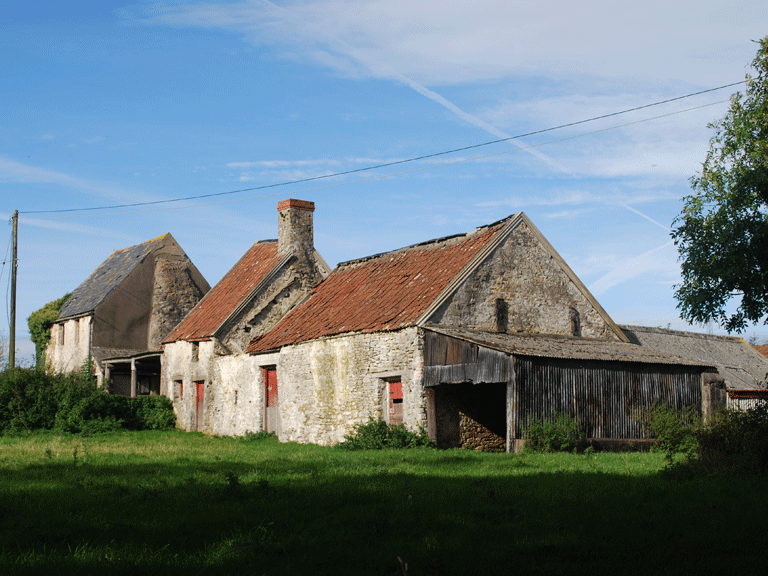
The post-medieval settlement of the area is characterised by a dispersed scatter of farmsteads and lesser dwellings, cottages, including Leach (Liege) Castle Farm, probably of 17th century date, and Tyle (Tilau) Cottage, the now extended cluster of cottages at what is now known as Liege Manor. The vernacular style of the area is perhaps best represented by Whitewell (or Whitehall), a regional house at least of 18th century date, with a gable chimney (stacks now removed), and chimney backing on entry (PRN 01495s; NPRN 28,027; RCAHMW 1975, 453, 461 maps 29 & 3), steep gables under slate roof, and additions. This farm has a number of attached and free-standing outbuildings (NPRN 41,558) including an associated, formerly attached linear range of random rubble walls and pantile roofs, which includes a steep gabled structure (bake house?) with single tall gable stack, again probably of 18th century date. Standing building types include farmhouses, cottages and place of worship (non-conformist, now converted to a dwelling). The principal building material noted is random limestone rubble, with later 19th century buildings having brick detailing to windows and doors, render also noted. Typical roofing materials includes slate, and tile as well as modern asbestos roof sheeting.
Relict archaeology includes prehistoric features such as the enclosure cropmark near Abernant (NPRN 305,439), and medieval settlement and fields including a DMV (RCAHMW 1982, (DV28), 243) in the vicinity of Leach Castle Farm, and also around Liege Castle Chapel (PRN 00362s), with a possible sunken way. Relict enclosures were also noted immediately to the south of Liege Castle Chapel during the current project, whilst other features associated with this hamlet are visible near the scheduled Castell Moel (SAM GM298; PRN 00359s). The latter a univallate hillfort or defended enclosure of possible Iron Age date (a late Roman/Early-medieval date has also been postulated), the site comprises a much-eroded gently curving rampart or ramparts (RCAHMW 1976b, (638), 27-30), also known as Liege Castle (SAM GM298; PRN 2234s) after the site of a small moated site of 13th century date which was constructed in the interior of the prehistoric enclosure. A cursory glance at the cartographic and aerial photographic material indicates the curving rampart of the prehistoric defended enclosure is in fact part of a much more extensive curving boundary fossilised in the hedges of the post-medieval landscape, which defines a large elliptical enclosure, at odds with the surrounding fieldscape of generally rectilinear, sub-rectangular and rectangular fields. The elliptical enclosure is sub-divided internally by post-medieval (?) enclosures, which may in fact be at least medieval in date, with evidence of ridge and furrow ploughing also visible (NPRN 24,320; RCAHMW 1982, (FS 11), 312). The modern track to Tyla Cottage, now also traverses the feature. Buried archaeology is represented by the prehistoric crop mark at Abernant (NPRN 305,439), and it is highly likely this area contains many others features as yet not identified.
Whilst the military/defensive characteristic is represented by the prehistoric hillfort of Castell Moel and its medieval successor Liege Castle moated site, these features are probably better viewed as status settlement and administrative centres, with a veneer of defence.
Minor ecclesiastical characteristics are provided by the site of the medieval Liege Castle Chapel and cemetery, part of a once larger rural settlement, now a shrunken settlement or DMV, represented by a small dispersed settlement cluster around Leach Farm and Liege Castle, consisting of three 17th century farmhouses. The possibility that Liege Chapel once formed part of Greendown grange has been raised, though this is unconfirmed. However, whilst it does not constitute a grange, it is known that Margam Abbey held 10 acres of pastureland at a place named as Moys or Moyl in documents of 13th and 14th century; this location is thought to be Castell Moel or Liege Castle. Though now converted to a dwelling, the later 19th century non-conformist chapel, Carmel Chapel (Independent), depicted on the 1st edition 25" OS map of 1878, continues the ecclesiastic theme into the post-medieval period.
Industrial archaeology represented by small-scale agricultural quarrying and associated lime production, remains including limekilns, noted on the 1st edition OS map.