Llancarfan
002 Lower Llancarfan Valley
HLCA 002 Lower Llancarfan Valley
Medieval/post-medieval field system; post-medieval settlement: clustered and loose dispersed scatter; post-medieval buildings; relict and buried prehistoric and medieval settlement; ecclesiastical and historic associations; water sources; relict agri-industrial features; traditional boundaries; minor communication. Back to Map
Historic Background
The historic landscape area of Lower Llancarfan Valley is the area of the deeply enclosed Nant Llancarfan river valley immediately south of the settlement of Llancarfan. The area contains at the north the stream confluences of Moulton Brook with Ford Brook and ultimately confluence of the latter with the Nant Llancarfan and at the south the confluence of the Nant Llancarfan with the River Waycock just north of Kenson Bridge, the southern extent of the character area. The area encompasses areas of ancient replanted and ancient semi-natural woodland including Breech Wood, to the south of Castle Ditches.
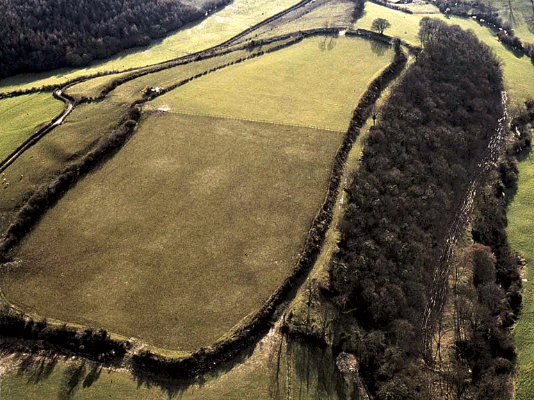
Occupation during the prehistoric period is represented by the Iron Age hillfort enclosure of Castle Ditches, a scheduled ancient monument (SAM GM071; PRN 00383s), located on a commanding position on a high spur overlooking the Nant Llancarfan Valley at the confluence of Ford and Moulton Brooks. The enclosure measures approximately 355m east to west by 116m north to south covering a fairly level plateau area on the west of an elongated spur; the plan of the univallate hillfort being governed by the topography of its location. The nature of the ramparts at Castle Ditches has been investigated through excavation. Focused on the area around the entrance at the south, excavations revealed a construction technique of mixed clay and rubble with dry stone revetment. Continuous occupation of the Castle Ditches hillfort and the surrounding area into the Roman period and beyond is evidenced by finds from within the hillfort enclosure of later Roman pottery sherds (PRN 02981s), and a rectangular earthwork feature to the south of Ford Farm recently identified from aerial photographs; the latter site considered to be Roman, or possibly Early-medieval date, comprises the ploughed out remains of a bank and ditch.
Land at Pen-onn was part of a grant made to the Abbey at Gloucester at the end of the 11th century; between 1091 and 1104 Robert Fitzhammon granted 15 acres of land at Pen-onn to the Abbey of St Peter, Gloucester; and Robert, Earl of Gloucester, in 1139-47 confirmed the monks possession of 'the vill of Treigof with the land of Pennune.' These lands are known to have remained abbey lands until the Dissolution, when they passed to the dean and chapter of the cathedral (RCAHMW 1982, MG 48, 303). This suggests the possible existence of a grange (PRN 00701s) at Pen-onn. Whilst no associated grange buildings have been positively identified, an abandoned farmstead in the form of a series of earthworks including a large rectilinear platform, a smaller square platform and faint traces of a number of enclosures considered to have been orchards or crofts has been recorded by the RCAHMW at Penn-onn in association with finds of 12th to 14th century pottery. This site is considered to be a possible location of the grange buildings, which belonged to Gloucester Abbey (RCAHMW 1982, LH 43, 56-57).
Relict or buried features associated with the former Tuck mill at Kenson Bridge, identified from a manorial map of 1622, may also survive.
A famous son of the area born in Pen-onn, is Iolo Morgannwg (Edward Williams 1747-1826) notable for his role in Welsh literature and the assertion of 'Welshness' in the south of the country, particularly in Glamorgan during the 18th century. A romantic poet, antiquarian and reviver of bardic tradition, Morgannwg was a leading authority in the growth of Welsh literature and the nations history.
Historic Landscape Characteristics
Lower Llancarfan Valley is an area characterised by post-medieval fieldscape of large semi-regular enclosed fields established before the publication of the tithe map of 1840. Some hints remain as to the earlier medieval pattern along with strong elements of the prehistoric landscape in the form of Castle Ditches, the Iron Age hillfort enclosure that dominates the north of the character area.
The main element to survive from the post-medieval period in a recognisable form is the area's field system, which includes large semi-regular enclosed fields representing the post-medieval amalgamation of earlier medieval strip fields, around Pen-onn in particular, and small areas of unimproved land around the Castle Ditches hillfort enclosure in the north of the area. Boundaries within the area are predominately agricultural comprising high hedgerows on banks, with mortared walls of local limestone associated with areas of settlement.
The main settlement of the area is the much altered small clustered post-medieval hamlet of Pen-onn, with a small number of scattered/dispersed farmsteads elsewhere, some of which may have had medieval precursors. The settlement at Pen-onn, considered possibly the site of a monastic grange, comprises of a small hamlet of irregular layout located at the junction of the road with tracks or lanes to the Nant Llancarfan and River Waycock. The hamlet, which has a mixture of building of various dates and types, now retains little of its early post-medieval character. Progressive alteration and additions to the area's main post-medieval settlement at Pen-onn occurred between the survey of the tithe map, and the 1st and 2nd edition of the OS 25'' maps. The tithe map shows a cluster of 13 or so cottages and farmhouses, by the 1st edition several of the cottages have disappeared, whilst a range of mid-19th century agricultural buildings has been erected at the northeast of the settlement: an L-shaped range with detached linear range (partly removed by 2nd edition and replaced by an additional wing to the L-shaped range), across a rectangular yard and a further detached linear building aligned north-south, located further south (also removed by the 2nd edition). The original dwelling of Pen-onn farm, a linear range at the northwest edge of the settlement with a number of small outbuildings or cottages nearby survives to be depicted on the 1st edition OS map; these have all been removed by the survey of the 2nd edition to be replaced by the present double pile building to the east closer to the mid-19th century farm buildings. The main survival from the earlier post-medieval settlement is a range of buildings at the site of the present extended 'Upper Pen-onn farm' (just south of the demolished earlier farmstead of Pen-onn), which is shown both on the tithe map and 1st-3rd edition OS maps.
Other settlement in the area is characterised by scattered farmsteads including Cliff Farmhouse, at the western side of the character area; a grade II listed post-medieval farmhouse building (LB 16,410), considered to be a good example of a 17th century thatched roofed farmhouse with later 19th century additions at either end, is of 3 room plan with a central doorway, winding stair by gable fireplace, and retains original features such as Ogee stopped beams (RCAHMW 1988). Cliff Farmhouse also has distinctive lime-washed elevations with decorative ridging and slate hung gabling. The south facing elevation retains three sixteen-pane sash windows, which flank a central four-panelled door with semi-circular fanlight above. Cliff Farm, in its earlier form, is depicted on the manorial map of 1622 and the mid-19th century tithe map.
Ford Farm is an example of a less well developed smaller farm unit consisting of a farmhouse and associated agricultural buildings. Ford Farm dates to at least the 19th century as it is depicted and noted as a homestead on the 1840 Llancarfan tithe survey, owned by Jesus College and occupied by John Griffiths who is also attributed occupancy of pasture just to the south that is listed as Ford Meadow. The farmstead is depicted on the 1st edition OS map (1879), as a east-west aligned linear range of dwelling and attached byre set into the slope. A narrow linear north-south aligned outbuilding lies detached to the north, just west of a D-shaped enclosure or yard and to the southwest near the ford is a detached double pigsty. By the 2nd edition a linear outbuilding with attached calf box at its west end parallel to and north of the dwelling across a rectangular yard has replaced both the earlier outbuilding and D-shaped enclosure. The farmstead and buildings of Castle Lodge Farm, just east of Castle Ditches Hillfort does not appear on the historic mapping, being a recent 20th century construction.
The grange granted to Gloucester Abbey by Robert Fitzhammon may have been farmed from a medieval settlement precursor located on the earlier of the farmsteads at Pen-onn, or the platform house and crofts noted further to the south (RCAHMW 1982, LH 43, 56-57), overlooking the Waycock Valley. There is also an ecclesiastical association linked to the adjacent landscape of Llancarfan through a possible Early-medieval site (PRN 04019s) noted from aerial photographs located south of Ford Farm just across the valley from Castle Ditches (SAM GM071). There is also evidence to suggest that the Castle Ditches hillfort may have continued to be occupied or was at least reoccupied during the Early-medieval period; some association with St Cadoc and the early monastic centre at Llancarfan is considered likely.
The area is also characterised by areas of surviving ancient woodland of semi-natural and replanted type located on the steeper valley edges. Additionally important characteristics in the area are the long-standing territorial and natural physical boundaries, in this case specifically important are the boundaries marked by watercourses including Moulton and Ford Brooks, the Nant Llancarfan and the River Waycock. These streams define to a large extent the bounds of this character area and are a key characteristic, initially demarcating the area around Castle Ditches hillfort enclosure and respected by cantref, hamlet and parish boundaries in turn. Other characteristic features include numerous springs and wells including the rag wells of Ffynnon-y-Clwyf (PRN 00391s), and Ffynnon Flamaiddan (PRN 00513s), both noted healing wells, the latter known for the cure of erysipelas (Jones 1954, 185). Relict industrial archaeological features relating to the agricultural landscape of the area include several limekilns, such as that shown just southeast of Castle Ditches hillfort (PRN 02632s) on the 1st edition OS map and disused by the publication of the 2nd edition, and another just west of Breeches Wood (old on the 1st edition OS map), the products from which would have been used for agricultural improvement and building construction and maintenance. A tuck mill (Tyckmyll) is depicted on the manorial map of 1622, north and adjacent to the Kenson River just upstream of the Kenson bridge, a building, now removed, is shown at approximately the same location on the tithe and 1st-3rd edition OS maps; relict or buried features associate with this former mill may also survive.
Communication links are a further definable characteristic feature of this area, consisting largely of winding lanes and footpaths, especially from Penmark to Llancarfan, it may be that these roads and footpaths initially respected the boundaries of earlier land ownerships, particularly those of medieval and post-medieval fieldscapes.