Llancarfan
010 Bonvilston Amalgamated Fieldscape

HLCA 010 Bonvilston Amalgamated Fieldscape
Amalgamated fieldscape: medieval/post medieval field system; traditional boundaries; agri-industrial features. Back to Map
Historic Background
The historic landscape area of Bonvilston amalgamated fieldscape represents an area of land that is largely a post-medieval agricultural landscape, with some agri-industrial features, located within the historic parish of Bonvilston. Roads bound the character area to the east, where the A4226 runs north to south from the A48, and to the west, where a more minor road runs north to southwest from the A48 down to the junction at Pancross. Part of the area is recorded on the 1839 Bonvilston tithe apportionment as belonging to Sir George Tyler and Robert Griffiths. The western and eastern thirds of this character area are part of lands belonging to the Bonvilston Manor grange, included in the papal bull of Pope Alexander IV in 1261 and recorded in charters from 1205 onwards (RCAHMW 1982).
There is little evidence for the early history of this character area, its key characteristic being its post-medieval fieldscape of large fields amalgamated from the former system. However, just outside of the area to the north are earthworks recorded individually as Bonvilston Earthwork and Bonvilston Ringwork (PRN 03830s and 00696s). Bonvilston Earthwork is described as a bank of approximately 146 metres in length and potentially part of a bailey, Bonvilston Ringwork as an oval earthwork that may be part of a bailey. It seems likely that these earthworks are part of the same historic feature of potential medieval date, which have been recorded separately.
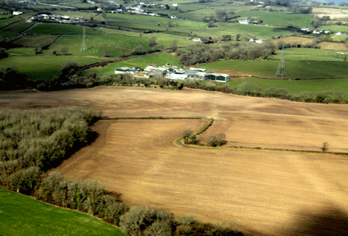
First edition OS maps depict regular enclosures and show the remnants of the medieval strip field system. Although now amalgamated into larger fields, the boundaries of the former strip fields are still visible as cropmarks in aerial photographs, despite the heavy ploughing the area appears to have undergone.
The boundaries that previously existed here are denuded and largely ploughed out the result of amalgamation; these earlier boundaries visible in aerial photographs may survive in places as low earthworks. One major boundary formed of a low earthbank with hedge and distinctive trees does survive, running north to south between the large fields. There is also another major boundary division of the landscape in the form a trackway, which can be seen running east- west through the area. Additionally the area also includes some small copses of broadleaf woodland. Within this broadly agricultural landscape area, there are a handful of agri-industrial features including a limekiln depicted on and in existence from at least the 1st edition OS map and also an extant quarry, presumably for lime.
Historic Landscape Characteristics
Bonvilston amalgamated fieldscape is characterised by the post-medieval agricultural landscape of large fields formed by the merging of the smaller fields of the earlier medieval and post-medieval field systems.
The historic field system, a defining characteristic of this area, can be discerned both on 1st edition OS maps and on modern aerial photographs as regular enclosures showing the traces of the former earlier medieval strip fields or quillets. Forming a strong characteristic feature of the area, the level of preservation of these cropmarks/earthworks is surprising given the heavy ploughing which appears to have taken place in the area since their apparent formation during the medieval and post-medieval periods.
Small areas of broadleaf woodland, forming field boundaries and small copses, are an additional characteristic of this agricultural landscape.
Further minor characteristics within this post-medieval agricultural landscape are the agri-environmental features of the same period, a limekiln shown on 1st edition OS maps, and, probably associated with this, an extant quarry, presumably for the extraction of lime.