Llancarfan
005 Crosstown and Llancadle (East) Agricultural Plateau
HLCA 005 Crosstown and Llancadle (East) Agricultural Plateau
Medieval/post-medieval agricultural landscape; dispersed medieval/post medieval settlement; Medieval/post-medieval buildings; buried prehistoric archaeology; communication. Back to Map
Historic Background
The historic landscape area of Crosstown and Llancadle (East) Agricultural Plateau represents a generally level area of fieldscape of medium and large semi-regular enclosed fields. The area is bounded to the south and east by river valleys, Kenson and Lower Llancarfan respectively; three roads dissect the area, one running south and west from Pancross though the area that eventually joins the B4265, a second that runs south from Pancross cuts down the east edge of the area towards Penmark, and a third running east to west across the bottom of the area above the Kenson River Valley and acting as a link from Penmark to Llancadle. Located in the parish of Llancarfan and formerly the hamlets of Llancadle and Llanbethêry on the 1840 tithe map, the area had formed part of the Early-medieval cantref of Penychan and the later Hundred of Dinas Powys.
Occupation of the area dates back to the prehistoric period attested to by the presence of a number of cropmark sites identified from aerial photographs, which are thought to have a prehistoric date (NPRNs 89,367; 89,368; 89,369; 89,370; and 89,371). These are mentioned in HLCA 003 as potential farmstead features, it was suggested that an association between the current character area HLCA 005 and that of HLCA 003 existed with the movement of people or livestock (such as cattle) between these potential farmsteads and the River Kenson. A number of other cropmark features have also been identified further north in the character area these have an unknown date but are described as enclosures and part of a field system (NPRNs 309,459; 309,460; 309,461; 309,462; 309,463; and 309,464).
The existing field system is as depicted on the 1840 tithe, and later OS mapping. The manorial map of Llancadle dating to 1622, indicates that the surviving boundaries form the bones of a once more complex pattern of closes, or medieval strip fields, which by this date appear to have been largely enclosed, though by 1840 had subsequently been amalgamated into larger fields. The 17th century manorial map identifies five named groups of closes: 'Redlandes', 'Rack Closes', 'Middle Crosse', 'Lorde's Lande', and 'Ten Acres', and interestingly the surviving enlarged enclosures reflect these groupings. It is likely that the surviving boundaries here originated during the medieval period (Davies 1956).
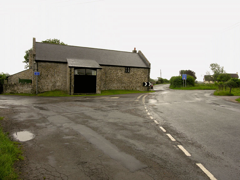
Depicted on the 1879 1st edition OS map are a number of buildings, which have remained relatively unchanged since this date. Included are agricultural outbuildings at Middlecross (NPRN 37,611; PRN 01969s) in the central and western part of the area, which are likely to have had a post-medieval origin. A number of other buildings to the north include further agricultural buildings and the vicarage at Pancross which are also likely to be post-medieval in origin, a house at Crosstown (PRN 01428s) in the north of the area is also included. The house at Crosstown was important among the Glamorgan gentry from the medieval period onwards and is associated with the Giles family. The house is a late medieval hall-house that was modified in the 16th century and again more recently extensively altered, the first documentary evidence for the building dates to 1561, where it is detailed as belonging to John Giles, later records include Crosstown amongst mansions of the Glamorgan gentry.
Historic Landscape Characteristics
Crosstown and Llancadle (East) Agricultural Plateau is largely characterised by surviving post-medieval field system; consisting of medium and large almost regular enclosed fields. An echo of the earlier medieval field pattern of strip fields is preserved in the surviving boundaries, which can be demonstrated to be on similar alignments as those shown on the manorial map of 1622, which in turn defined discrete areas or groups of strip fields.
Settlement in the area is characteristically dispersed and includes a range of post-medieval agricultural buildings at Middlecross, including a barn (NPRN 37,611; PRN 01969s) and detached outbuilding all within a group of rectangular enclosures (the farmhouse at Middlecross lies outside of the character area), a series of recent large agri-industrial sheds have been added to the complex. Of particular note is the house at Crosstown (PRN 01428s); here the main part of the building consists of a much-altered medieval hall house with inserted 16th century fireplace backing onto cross-passage. Although not listed Crosstown does retain features of medieval date, namely the two-centre headed doorway with plain-chamfered jambs to the cross-passage, and a trefoil-headed single light. Later alterations to the building during the sixteenth century included the insertion of the hall fireplace with its plain chamfered stone jambs and timber bressumer, and a doorway alongside with plain chamfered stone dressings and Tudor arch, other features included a hollow and ogee-moulded beamed ceiling (now removed) in the hall.
Other settlement features include the mid to late 19th century vicarage to the southeast of Crosstown; set slightly back from the road this appears on the 1st edition OS map of 1879; though is not shown on the 1840 tithe, when the site is noted as pasture under the ownership of the Reverend William Lisle and Meakham Berkin. This vicarage appears to have replaced an earlier vicarage located within the village of Llancarfan itself. The farm of Pancross falls within the adjacent character area HLCA 006, because of its radically altered character, currently more in tune with the altered fieldscape to the north.
An interesting characteristic that relates to a much earlier activity in the area are the five potentially prehistoric cropmark and earthwork features that survive on this agricultural plateau. Identified from aerial photographs these features are to an extent unexpected, since the area has had a long history of agricultural use it is remarkable that cropmarks and earthworks of this date survive as they do, and also because of the relative lack of any similar features in the majority of the remaining character areas. A number of post-medieval cropmark features have also been identified from aerial photographs, adding to the cropmark rich character of this area.
Communication links area also an important characteristic of this area; the area contains the junction of major routes through this and the wider Llancarfan valley area. One route runs south and west from Pancross though Middlecross and Llancadle that eventually joins the B4265; a second runs south from Pancross, starting further north outside of this character area in Llancarfan it follows the east edge of the character area towards Penmark and Fonmon above the Nant Llancarfan; and a third runs east to west across the bottom of the area above the Kenson River Valley acting as a link from Penmark to Llancadle. The roads provide significant links between places/settlements both within, and outside the character area; linking at the junction at Pancross, which joins a main route north through the Vale towards Llantrithyd and beyond. The western boundary of this character area is formed by another significant north-south route; this is a main ridgeway route, which connects the east-west routes of the A48 and the B4265. Unlike most of the narrow 'enclosed' lanes of the area, generous wide grass verges bound this road, an indication of its traditional use as a drove route, and as a main artery. Such routes have been identified as having prehistoric origins elsewhere; and this route is certainly of longstanding significance, acting to connect major east-west routes through the Vale, such as the A48 to the north, the 'Portway' of possible Roman origin, and the A4226/B4265 to the south, which might be of medieval or earlier origin. This communication link would appear to have been of particular significance during the medieval period; the location of the ringwork and bailey (PRN 00904s; NPRN 307,703), within an adjacent character area (HLCA 006), and the existence of manorial centres at the castles at Fonmon and Penmark, reflect this.