Gower
084 Bishopston Valley
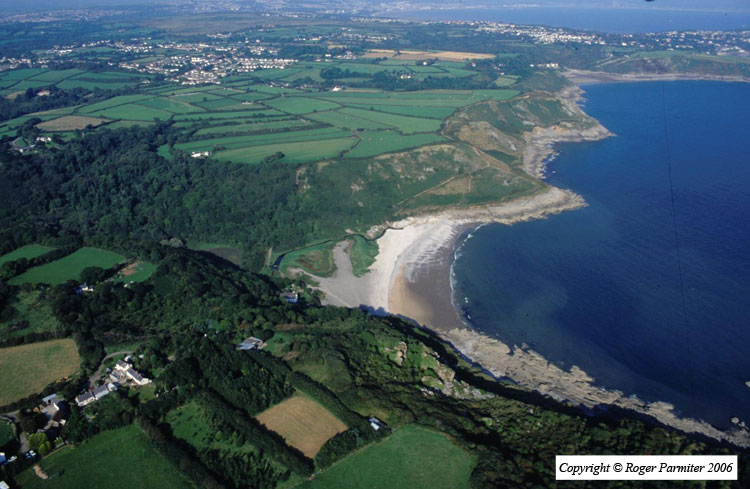
HLCA084 Bishopston Valley
River valley landscape: ancient woodland; caves; prehistoric domestic/defensive settlement; industrial features; exploitation of natural resources; communication networks; post-medieval ruined buildings. Back to Map
Historic Background
The historic landscape area of Bishopston Valley represents an area of enclosed wooded river valley, running approximately north - south from below the main settlement at Kittle to Pwll Du Bay. This area bounded the former manors of Bishopston to the east, Pennard to the west and the fee of Kittle to the northwest and lay within the later parishes of Bishopston and Pennard.
Numerous caves are known to exist in the area, including Pennard East Cliff Cave (05338w), Gut Hole (04427w), Meander Cave (04428w), Rising Cave (04429w), Lower Daw Cave (02290w), and a rock shelter (04430w); none have so far produced evidence of prehistoric occupation, Pennard East Cliff and Lower Daw Caves have the most archaeological potential.
An Iron Age promontory fort (00309w; 3013470; SAM GM126) southeast of Widegate, located on a steep sided spur about 30m OD overlooking the river valley bottom, provides the earliest evidence of occupation in the area. The site is defended by two deep rock-cut ditches largely surrounded by a dense coverage of trees. Excavations of the fort by Aubrey Williams in 1939 identified an entrance to the north and Iron Age pottery as well as a ring and pottery dating to the 1st and 2nd centuries AD indicating continued occupation of the area into the Roman period. A Roman presence is also found in the surrounding areas, particularly around Barland Common and Bishopston itself.
Early-medieval settlement in the surrounding area of Bishopston (HLCA 086) is evidenced by the church dedicated to St Teilo, the site of one of the earliest Christian settlements in Wales (Orrin 1979, 27) mentioned in the book of Llandaff in the sixth century. It is likely therefore that this area was utilized from the Iron Age (if not before) through to the Early medieval period as an important resource along with Ilston and Clyne valleys being a major river valley in east Gower, providing water and other resources and acting as a longstanding territorial boundary.
From the medieval period onwards the land of the valley floor was largely used as meadowland, field divisions (02293w) can still be seen today, however, they are no longer utilized and mostly overgrown. Surveys during the seventeenth century mention meadowland in the parish of Bishopston. The tithe maps of Bishopston and Pennard 1844-46 depict a number of fields recorded as pasture, arable and meadowland (Poucher 2002/2003) along the flat valley floor at the southern end of the valley and around the promontory fort. These are also shown on the first, second and third edition OS maps. It is possible that the fertile valley floor was also exploited during the Iron Age.
During the post-medieval period industrial activity in the area increased, particularly in the nineteenth century from which the majority of remains date. Collapsed caves such as Lower Daw Pit (02289w) were exploited for stone and quarries were located at various other outcrops. In association with these quarries are numerous limekilns most of which date to the first half of the nineteenth century when the limestone industry was at its peak. A lead mine at Long Ash can also be found in the area (02291w), apparently worked along with All-Slade mine, a more successful mine near Brandy Cove. Increased demand for lead in the nineteenth century resulted in Long Ash lead mine being opened in 1852 but it seems it was not extensively worked (Poucher 2002/2003). Ruined buildings in the area of nineteenth century date may relate to these activities. A building located next to the lead mine entrance (02292w) appears to have been a shelter or barn later used as a mine building. A second building (02296w) in a very ruinous condition may have been a small pub servicing the quarrymen of the area. A house and garden were also in the area belonging to a John Griffin Hancoin; all these buildings are depicted on the tithe map (Poucher 2002/2003).
This area is now owned by the National Trust and is primarily a tourist/recreational area with wooded valley walks and a bridal way.