Merthyr Mawr, Kenfig and Margam Burrows
004 Kenfig Burrows
HLCA 004 Kenfig Burrows
Unenclosed burrows; buried archaeology: medieval settlement/fields, ie be-sanded Kenfig, military/defensive: Kenfig Castle; associated medieval ecclesiastical features; post-medieval rabbit warren; characteristic field boundaries; prehistoric find scatters; communications corridor; historic associations. Back to Map
Historic Background
The historic landscape area of Kenfig Burrows encompasses the main dune system south of the River Kenfig, which forms the northern boundary of the ecclesiastical parish of Pyle and Kenfig. The area is mostly coterminous with the Kenfig National Nature Reserve; and in conjunction with part of HLCA 005, also forms the Kenfig SSSI.
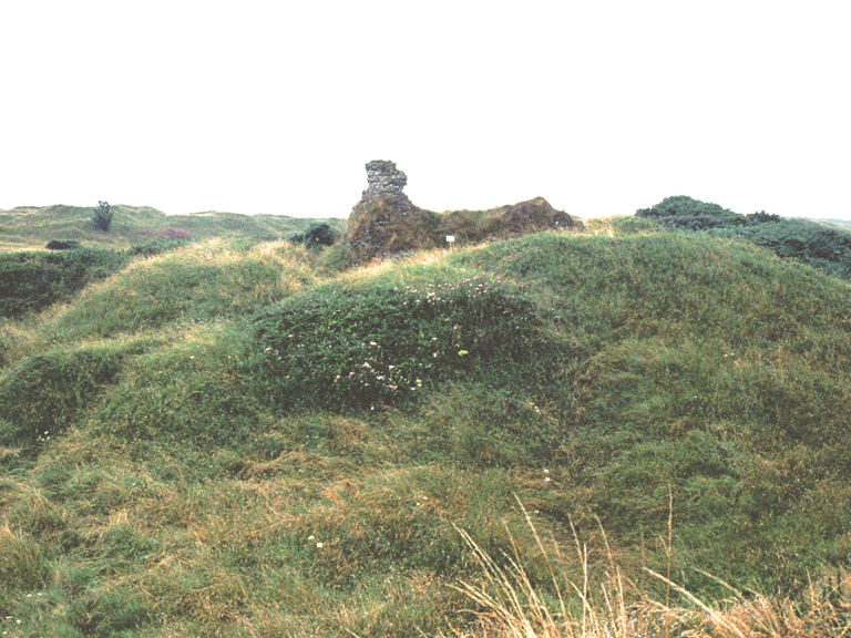
Prehistoric finds, including a polished axe (Penmaenmawr, or Graiglwyd type) of Neolithic date, indicates the area was settled from an early period. Perhaps the most significant element within the area is the be-sanded remains of the medieval settlement of Kenfig (SAM Gm 042); the settlement appears to have been established in the area west of the castle and St James's Church to either side of the Roman Road, or Heol Las, probably the High Street of the 13th century Ordinances, and with other streets appears to have formed a rectilinear street pattern. The town comprised two distinct elements: settlements both within and without its defensive wall. Though the settlement is noted for the year 893 in the Gwentian Brut, finds of Roman date might suggest an even earlier origin. The settlement, incorporated by 1147, had a turbulent history and suffered devastating attacks in 1167 and again in 1183, while further extensive damage occurred during the 13th century Independence Wars and at the hands of Llywelyn Bren in 1315. During the first half of the 14th century the settlement supported between 142 and 144 burgages. By 1470, however, the settlement had been abandoned to sand encroachment; between 1471 and 1485 a new church, St James's, had been constructed at Pyle to replace that at Kenfig and partly using material taken from the latter, with the new settlement established further east along the highway between Mawdlam Church and Ewenny.
References indicate that Iestyn ap Gwrgan, the last native ruler of Morgannwg, had a castle at Kenfig in 1080, although the location of this site is still to be ascertained. The known medieval castle at Kenfig (SAM Gm 042), the subject of limited excavation in 1924, is thought to have been constructed before 1135 and is mentioned in records of 1183 and 1232. Initially the site comprised a tower within a polygonal enclosure protected by a timber-built palisade and ditch. The castle was later re-built in stone, probably following the Welsh attack of in 1183 and subject to further alterations in 1232 and 1295 after further uprisings, before being finally dismantled in 1405.
The area also includes Kenfig Pool, the largest stretch of natural freshwater in Glamorgan, this formed part of a fishery belonging to Margam Abbey during the medieval period and shown on a 16th century map as having been connected to the sea by a channel or 'gutter'.
During the post-medieval period the area was used as a rabbit warren, sale particulars of 1782 when the area was sold to the Talbots of Margam, detail a warren of 100 acres bounded by stonewalls.
Historic Landscape Characteristics
Margam Burrows/Twyni Margam is characterised as an area of coastal sand dunes, partly tipped over with recent waste from the adjacent steel works. Beyond references to use of the area as a rabbit warren during the medieval period and to features associated with defence during World War II, direct historical characteristics are generally elusive.