Merthyr Mawr, Kenfig and Margam Burrows
007 Kenfig and Mawdlam

HLCA 007 Kenfig and Mawdlam
Post-medieval settlement and agricultural landscape with medieval precursor; medieval and post-medieval fields; distinctive boundaries; ribbon development settlement pattern; post-medieval vernacular buildings; ecclesiastical features; communications: footpaths, tracks and straight lanes; historic associations. Back to Map
Historic Background
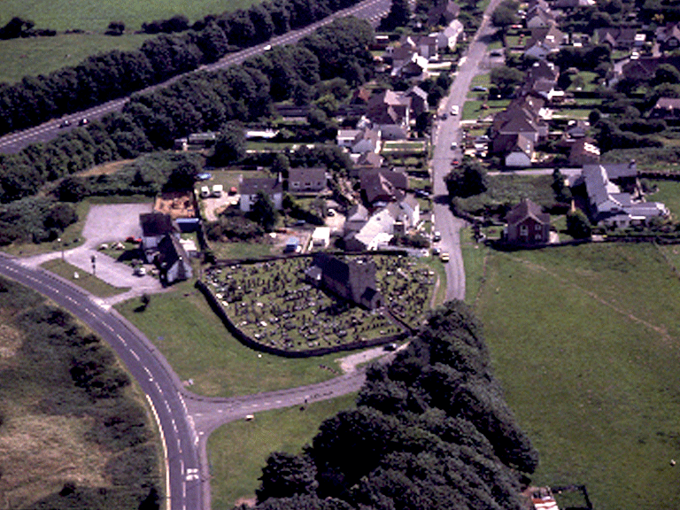
The historic landscape area of Kenfig and Mawdlam contains the surviving agricultural settlement of Kenfig and Mawdlam, and represents in part the new settlement established further east along the highway between Mawdlam Church and Ewenny constructed from the latter part of 15th century replacing the be-sanded town of Kenfig. Most of the area was part of the post-medieval estate of Margam Abbey. A major landscape feature of the area is the medieval church of St Mary Magdalene, Maudlam, with its highly visible tower, reputedly founded in the 13th century as a chapelry to St James' church Kenfig. The graveyard enclosure surrounding the church is sub-rectangular and may indicate an earlier origin for the site.
Of particular interest is the Prince of Wales Inn, (or Ty-newydd, site of medieval/early post-medieval Guildhall) which began as a meeting chamber raised on pillars is thought to possibly contain early 17th century fabric, paid for by the 1605 bequest of one Evan Griffith for the 'building of a courthouse in Kenfig'. Rebuilt in 1808 and remodelled during the 19th and 20th centuries, the building served various borough functions and formed a focus of the former decayed borough of Cynffig/Kenfig. The Guildhall was where the burgesses of Kenfig assembled under an elected portreeve and 12 aldermen, and also provided the venue for Courts Leet, Courts of Pleas, Inquests, Hall Days and Gwyliau Mabsant, and from the 1670s provided a schoolroom.
The area contains a number of interesting examples of post-medieval architecture, set within contemporary agricultural landscape. These include Pool Farm, a substantial 17th century farmhouse of regional type, with good detail, originally of lobby-entry plan, but remodelled in 19th and 20th centuries; Kenfig Farm, a regional house of lobby-entry plan with internal chimney, fireplace stairs, and sunk-chamfered windows; and Sunnyside, another regional house with internal chimney and lobby entry.
The area is traversed and bordered by numerous communication features, the earliest being Heol-las, Heol-y-sheet and Water Street, Roman Roads subsidiary to the coastal highway of Julius Frontinus, which continued as main arteries of communication into the medieval period and beyond and influencing the layout of the area's settlement and its field pattern.
Historic Landscape Characteristics
Kenfig and Mawdlam is characterised as an area of settlement: Kenfig and Mawdlam, dating to the post-medieval period with medieval precursors. The settlement is characterised by ribbon development settlement pattern and essentially comprises farmhouses, cottages and terraced cottages, augmented by modern detached houses, and bungalows. The historic character and texture of the area is substantiated by the area's post-medieval vernacular buildings, such as the Prince of Wales Inn, or Ty-newydd (site of medieval/early post-medieval Guildhall; Grade II Listed), Kenfig Farmhouse and Pool Farmhouse (listed grade II), a substantial 17th century regional farmhouse with good surviving details.
Another striking characteristic of the area is the survival of the medieval and post-medieval field pattern, particularly evident on aerial photographs, including surviving medieval strip fields, or quillets, and distinctive boundaries. The relationship between the settlement and the agricultural landscape is characteristic with linearly arranged farmsteads/cottages within rectangular plots, frequently set back from and at right angles to the road. A strong ecclesiastical element to the area is provided by the medieval church of St Mary Magdalene, Mawdlam (Grade II* Listed), with its cemetery and cross base. While the historic character of the area has been heavily influenced by local communication networks, which range from footpaths, tracks and straight lanes, including Heol Las, a road with Roman origins.
The area has interesting historic associations with particular emphasis on the functions of the Guildhall.