
Blaenavon
HLCA 009 Cefn Garnyrerw and Pen-ffordd-goch Extractive Area
HLCA 009 Cefn Garnyrerw and Pen-ffordd-goch Extractive Area
Relict industrial landscape characterised as open upland common and principal early extractive area in Blaenavon for coal, iron ore, fire clay and limestone. Important transport networks and features and intensive water management systems. Post-medieval encroachment.Back to map
Historic Background
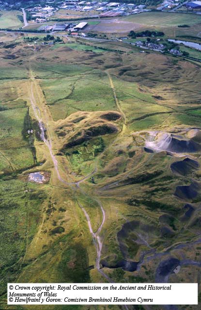
The historic landscape area of Cefn Garnyrerw and Pen-ffordd-goch Extractive Area encompasses the surviving open upland common within the limits of the northeastern outcrop of the South Wales coalfield, not subjected to opencast operations during the 20th century.
Mineral extraction in this area dates back to at least the 17th century; an exceptional area of patching and scouring remains is at Pen-ffordd-goch (SAM: MM227) where iron ore was extracted from outcrops on the hilltop. Extraction grew after the establishment of Blaenavon ironworks near the end of the 18th century. The approaches and tips of adit mines driven before 1812 can still be seen around Pen-ffordd-goch. Other preserved features in this part of HLCA009 include leats, hushing dams, scours, levels, shaft mounds, tracks and tramroad formations. These features can be easily dated as scouring had ceased by 1817 when the reservoir was built to serve Garn Ddyrys ironworks. It is known that the Hanbury family of Pontypool worked some of this area during the 17th and 18th centuries, including the coal and iron ore workings west of Abergavenny Road (SAM: MM297), where many hand-dug features survive. A well-preserved early 19th century ironstone quarry of national importance is located in the north of the area at Carreg Maen Taro (SAM: MM295).
Later workings in this HLCA demonstrate advancements in mining technology. These include New Pit, Balance Pit and Hill's Pits; the latter sunk in 1839 to exploit coal and ironstone deposits, retains a stone chimney (Listed: Grade II). During the 19th century numerous levels, quarries and pits were worked throughout the area, among these were Peggi's Level (clay) and the ironstone level and quarry near Tir Abraham-Harry.
Associated with these extractive features were a complex water management system and an extensive tramroad network; substantial remains of both survive throughout the landscape. The water management system provided water for the ironworks and water-balance systems of the local pits. One of the earliest transport routes in the area ran across the mountain near Pen-ffordd-goch from Pwll Du to the ironworks; this was replaced by a more efficient and easier route when the 2,400m long Pwll Du tunnel was constructed from earlier mining workings around 1815 to carry raw materials via Hill's Tramroad and Pwll Du through the mountain to the ironworks. The southern and northern entrances to the tunnel lie in HLCA006 and HLCA011 respectively.
Limestone from quarries on the Blorenge was transported through this area to the ironworks from the end of the 18th century onwards. As the volume of goods being transported increased, new transport routes were needed. In 1850, Thomas Dyne Steel, a Blaenavon Company engineer designed a double-inclined standard gauge railway, the Dyne Steel Incline (SAM: MM280), which ran between New Pit and Pwll Du Quarry. Tramroads were also constructed at New Pit, Pen-ffordd-goch, and Hill's Pits, where a counterbalanced tramroad incline was used from 1840s to carry coal to the ironworks. The brake engine of the latter still survives (SAM: MM222).
Historic Landscape Characteristics
Cefn Garnyrerw and Pen-ffordd-goch Extractive Area is essentially an unenclosed, relict industrial landscape dominated by surviving remains dating back to the 17th century. Characteristic workings include early remains of patch working and scouring, quarries, collieries, bell pits and drift mines. The area is dominated by waste tips of various periods associated with the workings. Built structures associated with these workings form a key characteristic element of the landscape adding to the understanding of the industrial operations formerly carried out in the area; the present condition of these features is varied. Important examples include the brake engine house on Hill's Pits tramroad incline, one of only two known in South Wales to retain parts of the breaking and winding machinery and the remains of a magazine powder house to the north of Garn Road (Listed: Grade II).
Transportation is an important characteristic of the area represented by tramroad and incline systems; for example the surviving cuttings and embankments of the Dyne Steel Incline remain visible and prominent features in the landscape. Many other transport features survive in good condition, including sections of the Blorenge quarries tramroad, Pen-ffordd-goch to Pwll Du tramroad, Ty'r Abraham Harry tramroad and Balance Pit tramroad. The course of the Pwll Du tunnel, significant as the longest tunnel on any British horse drawn tramroad, crosses the area. Tracks and lanes of indeterminate date, connecting workings and upland encroachment to the main valley transport network account for the remainder of transport features.
The area is also characterised by a large number of water management features: reservoirs survive at Ball's Pond, Hill's Pits, New Pit and Balance Pit in good condition, some along with their associated leats. The former reservoirs at Pwll Mawdy and Nant Llechan are less well preserved but nonetheless remain important elements of the landscape.
Small-scale settlement and encroachment in part related to the early industrial exploitation of the area remains an important though discrete characteristic of the area. The enclosure at Tir Abraham-Harry is depicted on early 19th century maps and is likely to be of 18th century or earlier date. Evidence for structures is present at a number of sites, including: Garn y Erw Row where field boundaries and building platforms exist; Hill's Pits where remains of roughly coursed, dressed stone cottages with associated plots of land are found; and at New Pit, where building platforms also survive.
The area has important historical associations through its close links with HLCA006, in particular relating to Thomas Hill and Thomas Dyne Steel.