Blaenavon
004 Coity Enclosed Landscape
HLCA004 Coity Enclosed Landscape
Area characterised by pre-industrial enclosed agricultural landscape and settlement possibly dating from the medieval period. Largely relict evolved/irregular field pattern. Traditional field boundaries. Domestic structures and agricultural buildings. Water management features.Back to map
Historic Background
The historic landscape area of Coity Enclosed Landscape reflects the extent of enclosed land and surviving pre-industrial agricultural landscape. The settlement and agricultural landscape of the wider valley area remained essentially unchanged until the upsurge of the iron industry during the nineteenth century. This area represents a rare and important survival of an agricultural landscape closely associated with the early industrial development of the Blaenavon area.
The Ebouth Vaure 'Bedellaria' and other freehold lands formed the core of this area during the early post-medieval period. By the eighteenth century approximately half of the area comprised leaselands, probably in part representing encroachment onto the former common.
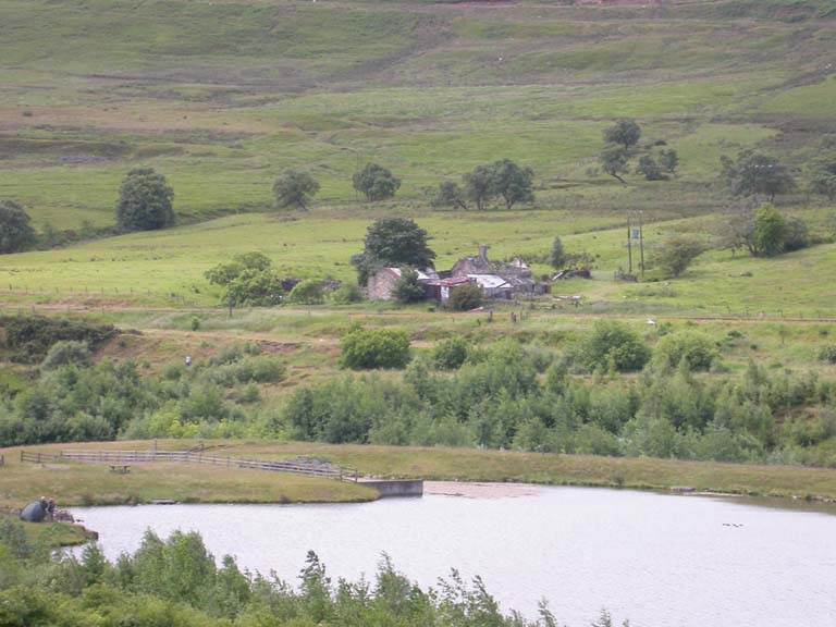
By the post-medieval period the settlement pattern of the area is typified by a dispersed scatter of farmsteads, some of which may have had medieval precursors. Cartographic evidence gives numerous agricultural holdings most of which are presently in a ruinous state, these are: Pen Marc, Ty Rhona, Ty Rheinallt, Troed-y-coity-mawr, Coity Mawr, Coity Canol, High Meadow, Field Farm, Coity Farm and Waun-Mary-Gunter Farm; only the latter two are occupied. All of the agricultural holdings in the area were leased or purchased by the Blaenavon Company from 1780 onwards.
Industrial activities affected the area during the nineteenth century; chiefly these were associated with small-scale extraction of coal and iron ore and include Waun Avon Slope and a colliery near Coity Farm. The area also contained a number of ventilation shafts associated with underground workings. Water management also played a role in the area: notably Coity Pond, built in 1839, to supply water for the steam engines at Forgeside. The element of water management was further developed in the late nineteenth century with the creation of additional reservoirs with associated leats near Coity Pond and also adjacent to the workers' housing at Forgeside. An important industrial transport feature of the area is Coity Incline (SAM: MM279), this was opened prior to 1844 to transport Pennant sandstone from Coity Quarry for the construction of the Blaenavon Iron Company's new housing and proposed works at Forgeside. The upper part of the incline fell out of use c.1880 whilst the lower part continued in use carrying coal form Coity Pit (Big Pit) and an adjacent level to the coke ovens at Forgeside until 1900. The landform of the area has otherwise remained relatively unchanged from the nineteenth century to the present day.
Historic Landscape Characteristics
Coity Enclosed Landscape is characterised as a surviving, but today, largely relict agricultural landscape of evolved, irregular field pattern with characteristic scattered, stone built farmsteads, generally variations on single range of buildings reflecting the long-house tradition and set tangentially to the slope. The traditional building materials include random rubble and coursed stonework, probably lime washed originally though brick is used in later structures. Some surviving buildings have been rendered such as Waun Mary Gunter. Traditional roofing material was probably originally thatch, however, no known surviving thatched example remains, current roofing materials being slate and corrugated iron.
Examples of long-house unit type include Shepherd's Cottage, Coity Canol: a stone cottage with adjoining barn and second cottage arranged down slope with adjoining yard and outbuildings to the north west; and Coity Farm: a double-fronted one and a half storey farmhouse with additional barn across north east end and later lean-to barn across lower end of long-house barn. Surviving period details at the latter include a structural stairwell and deeply recessed splayed window and sawn and pegged timbering. Other linear unit farmsteads are the late eighteenth century Field Farm: a one and a half storey dwelling of direct entry plan with a bakehouse at one end and large cowshed at the other, there is also a lean to at the rear; and Ty Rheinallt: a stone double-fronted one and a half storey dwelling with dormers, outshot to rear and extended long barn with farmyard and outbuildings behind.
Traditional field boundaries are also characteristic of the area, in particular dry-stone walling and stone-faced banks. In places, traditional boundaries have been augmented or superseded by post and wire fencing. Other agricultural features in the area include a drying kiln. An integrated part of the pre-industrial area would have been characteristic footpaths, tracks and winding lanes.
An important and characteristic transport feature is Coity Quarry Incline (SAM: MM279). The incline is well preserved from the quarry to Coity Pit, with a series of shallow cuttings and embankments. Buried remains of industrial workers' dwellings (Incline Cottages) associated with the incline and adjacent workings may survive in the area.
Characteristic of the area is an extensive drainage and leat system. Coity Pond reservoir and adjacent reservoir survive in good condition and Coity Pond is under consideration for scheduling.