Blaenavon
HLCA 011 Blorenge and Gilwern Hill
HLCA 011 Blorenge and Gilwern Hill
Relict industrial extractive upland landscape associated principally with limestone extraction. Other major characteristics are transportation networks and metal processing. The area is also characterized by relict industrial settlement, formerly isolated rows within discrete groupings, and by post-medieval encroachment and prehistoric funerary/ritual features.Back to map
Historic Background
The historic landscape area of Blorenge and Gilwern Hill encompasses the extent of unenclosed land around the Blorenge and Gilwern Hill outside the limit of the north-eastern outcrop of the South Wales coalfield and defines an area dominated by limestone extraction.
The earliest remains in the area relate to prehistoric funerary and ritual activity, evident on the Blorenge in the form of Bronze Age cairns; these comprise round barrows belonging to the Llanfoist Fawr barrow cemetery; one of which, located approximately at SO270119, is of national importance (SAM: MM219).
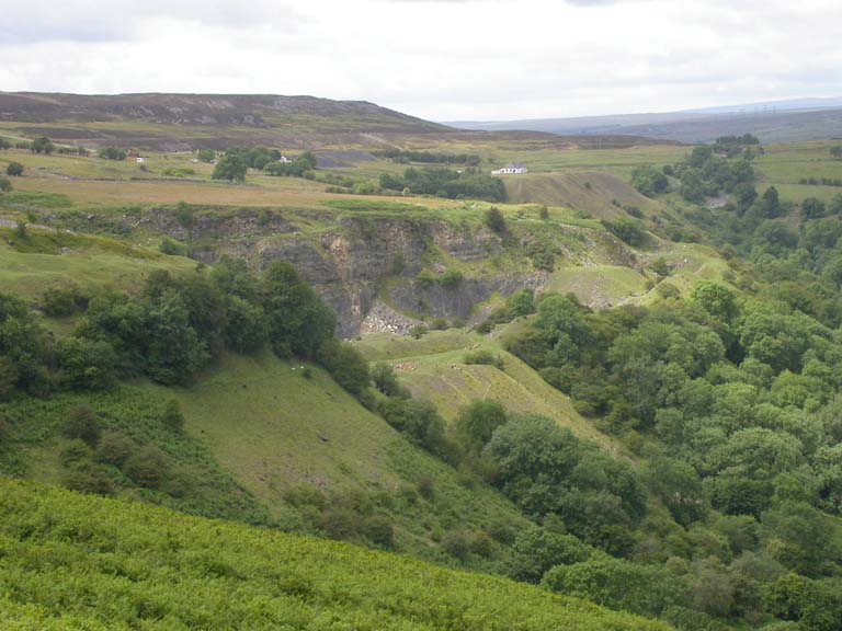
While a possible holy well site indicates medieval activity on the Blorenge, later activity is mostly related to extraction dating from the late 18th century to the late 19th century: the earliest of these are limestone quarries at Tyla on Gilwern Hill and on the Blorenge. Geological problems caused one of the earliest of the northwestern quarries on the Blorenge, initiated c.1795, to be abandoned 1804. This relatively short-lived and therefore significant site has been scheduled along with its tramroad (SAM: MM288). During the 19th century extraction of limestone from the area for the Blaenavon ironworks increased and new quarries were opened at Pwll Du. The limestone quarry at Pwll Du (SAM: MM225), dating before 1819, is exceptionally well preserved and contains many important features, the most important a water balance lift shaft which raised loaded limestone wagons to the tramroad. This quarry was operated by Walter Lewis to supply limekilns at Govilon and Llanfoist as well as the ironworks at Blaenavon and the forge at Garnddyrys.
Another significant quarry is Craig yr Hafod (SAM: MM278), which along with an adjacent agricultural limekiln, was in use during the early 19th century possibly associated with workings at Pen-ffordd-goch. This quarry was superseded in 1812 by larger quarries connected by tramroad to the canal. The site at Craig-yr-Hafod is of national importance as an exceptional example of an early limekiln with associated quarry.
A network of primitive tramroads was associated with these limestone workings. One of the earliest is the Blorenge Quarries Tramroad (SAM: MM288) built as a plateway c.1795; this fell out of use by 1804 following the closure of the quarry. With the completion of the Brecknock and Abergavenny Canal to Llanfoist in 1812, additional transport routes were established over the Blorenge. Such transport links were in response to an upsurge in demand for iron and corresponding increased production at Blaenavon ironworks, which peaked during the Napoleonic Wars. Thomas Hill, manager of Blaenavon ironworks, had already constructed a section from Pwll Du to the ironworks through the Pwll Du tunnel around 1815; the northern entrance (SAM: MM224) of the Pwll Du Tunnel lies in the area. Hill's tramroad became the main transport route for materials running from Blaenavon ironworks to the wharf at Llanfoist. A well-preserved later section includes the 40m long 'cut and cover' Blorenge tunnel (SAM: MM275). An extension of Hill's Tramroad, built c.1817-22, ran from Pwll Du to Llanfoist via Garnddyrys, with a small section extended part of the way across Gilwern Hill; the quarries at Gilwern having been previously linked to Pwll Du by earlier tramroads.
Hill's tramroad allowed pig iron from the Blaenavon ironworks to be taken to the forge at Garnddyrys (established 1817) for conversion to wrought iron; it passed under Garnddyrys through a tunnel approximately 120m long. Garnddyrys ironworks and a section of Hill's tramroad up to Pwll Du via Pen-Rhiw Ifor are scheduled (SAM: MM189). The section of Hill's tramroad to Llanfoist wharf largely fell out of use with the establishment of mainline railway links in the 1850s when this replaced the canal as the principal form of transport for the Blaenavon ironworks, while Garnddyrys ironworks went out of use c.1861, when a new site was built at Forgeside, close to the newly established rail links. From this time onwards extraction from the limestone quarries declined with some ceasing operation altogether by 1860.
Historic Landscape Characteristics
Blorenge and Gilwern Hill is characterised as a mainly unenclosed upland common used for grazing with an important characteristic represented by limestone quarrying. The area is currently important for leisure/tourist pursuits such as hang-gliding and walking.
Limestone quarrying is particularly evident at Pwll Du with its dramatic quarry face and nationally important water balance lift. Quarries are found throughout the area at Pen-Rhiw Ifor, Tyla, Gilwern Hill, Garnddyrys, Llwyncelyn Farm, Craig-yr-Hafod and on the Blorenge. Spoil tips related to these activities also remain characteristic features of the area.
Processing is also characteristic of the area: remains of industrial processing buildings survive at Garnddyrys and include puddling furnaces, a forge and rolling mill; while production of limestone products also formed a major aspect and remains of limekilns survive on the Blorenge, and at Craig-yr-Hafod and Tyla quarries.
Closely linked to the industrial processes of the area are water management features ie reservoirs, ponds, drains and leats. Reservoirs included Upper Pond and Lower Pond, which were both fed by Forge Pond to serve Garnddyrys Forge. Forge Pond (also known as Pen-ffordd-goch or Keeper's Pond) is still extant, though the ponds that supplied the water balance lift at Pwll Du quarry are now dry.
Fundamental to the industrial development of the area were the area's communication links. Surviving characteristic features include trackways across the Blorenge, some of early post-medieval/pre-industrial origin. Prior to the construction of the Blaenavon Company's road (the current B4246) in 1825, access between Abergavenny and Blaenavon was along a minor country lane over the Blorenge via Pen-ffordd-goch and Cefn y Galchen. Tramroads and their associated tunnels are the most significant transport features in the area: Hill's tramroad, a 2ft gauge plateway on stone sleeper blocks, passed through the Pwll Du tunnel, the Garnddyrys tunnel (a 'cut and cover', single-track tunnel of coursed rubble stone with round tunnel vault), and the Blorenge tunnel (also of 'cut and cover' type with both portals intact). Other dominant features on the Blorenge and Gilwern Hill are twentieth century communications towers.
Settlement in the area, associated both with industrial workings and minor encroachment, is a less visible characteristic of the area than previously. The historic built environment of the area was largely based on industrial buildings and related settlement at Garnddyrys Forge, Pwll Du, Pen-Rhiw Ifor, The Tumble and Pen-Rhiw. Unfortunately many of the standing structures in the area have been demolished, although buried remains are likely to survive. Little of the former settlement at Pwll Du, which comprised worker's housing, a school, public house, manager's housing (Pwll Du House), Blaenavon Company shop and stables, survives above ground today apart from the Lamb and Fox Inn. Workers' housing at Pwll Du included Lower Rank, a terraced row of 31 cottages built before 1819 (thought to be the earliest example of Blaenavon Company 'standard' housing); Upper New Rank, a terraced row of 17 two-storeyed, double-fronted stone cottages with associated bakehouse outbuildings and gardens with a chapel at the west end and similar cottages at Tunnel Houses among others. At Garnddyrys worker's housing consisted of two-storey, single-fronted, stone cottages with stones lintels and corbelled and barrel-vaulted rear larders built into the hillside (Garnddyrys Square); there were also fifteen stone cottages at Garnddyrys Row. It is likely that buried and some surface remains of these structures survive. Post-medieval encroachment is represented by small, discrete areas of enclosure, for example, around Pwll Du and Pen-Rhiw Ifor. A variety of boundary types can be found, including, dry-stone wall, stone-faced banks, earth banks, hedges and post-and-wire fences. Sheepfolds are also typical of the area as are boundary stones/posts, some of which mark the boundary of Blaenavon Company's mineral rights whilst others mark the limits of land ownership. Funerary and ritual features, ie cairns of Bronze Age date also form an important characteristic, reflecting an earlier land use.