Merthyr Mawr, Kenfig and Margam Burrows
012 Merthyr Mawr
HLCA 012 Merthyr Mawr
Post-medieval gentry estate: house, parkland and garden, and associated estate village; varied settlement pattern; post-medieval vernacular, picturesque and polite estate architecture; post-medieval agricultural landscape; distinctive field boundaries; relict prehistoric and medieval settlement/fields. Back to Map
Historic Background
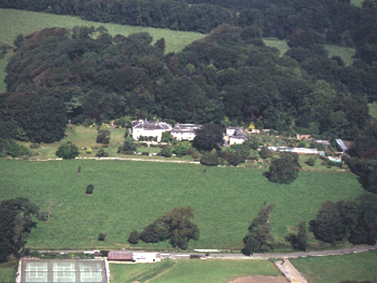
The historic landscape area of Merthyr Mawr is a landscape of some importance and includes the bulk of the registered park and gardens of Merthyr Mawr House (PGW: site evaluation Grade II*; Listed buildings Merthyr Mawr House and stables (grade II); lodge (grade II), included as a 'small, attractive landscape park laid out at the same time as the house was built in the early nineteenth century. Contemporary pleasure grounds with some good specimen trees and shrubs, and gardens with a very fine large glasshouse of 1900. Remains of the walled gardens of the earlier house.'
It should be noted that the boundary of character between HLCA 012 and the adjacent HLCA 018 is at best imprecise and difficult to define, with many characteristic traits overlapping and in common. The most obvious and historic boundary in the area is the Afon Ogwr (river Ogmore) itself, despite minor differences between historic, parish boundaries, agricultural holding boundaries and more recently designated boundaries; for this reason the boundary between the HLCAs has been placed along the line of the River Ogmore itself. This satisfies the area of the park and garden as defined on the 1st edition OS 6-inch map. HLCA 013 is defined as those parts of the demesne land lying within the parish of Merthyr Mawr, and an area of associated farmland adjacent to the west around Warren Farm. Two enclosures contained within the registered park and garden on the opposite side of the Ogmore River notably Coed Pwll-y-fflew and Waun-y-fervill (only the latter formed part of the Merthyr Mawr Demesne land in 1813) have been included within HLCA 018.
The house of Merthyr Mawr was constructed between 1806 and 1809 on a new site by Sir John Nicholl in a classical style (Henry Wood of Bristol, architect and sculptor), replacing the earlier 16th/17th century Hall of the Stradling family (St Donants). The house is a five-bay two-storey classical mansion faced in white local carboniferous limestone, with a hipped roof and sash windows, and central single-storey porch with Tuscan columns in the north front. A lower wing, partly built later than the main projects to the east, while on the west side a veranda with a glass canted roof supported on cast-iron pillars, built in 1819, runs along the entire length of the house. The Old Hall was situated to the south-west of the 19th century house, on or near the site of the Farm; remains of the Tudor courtyard now forms one of the farm outbuildings, the rest having been demolished c 1806.
The park was designed and planted between 1806 and 1838 by Sir John Nicholl, most of the work being carried out after the house was completed in 1809. An estate map of 1794 by John Williams shows the area of the park as fields, with very little woodland, and with the old Hall and its gardens along what became the west boundary. The garden and grounds were laid out by Sir John Nicholl between 1806 and 1838, at the same time as the park was made. The present layout differs in some respects from that shown on the William Weston Young estate map of 1813 and on a drawing of the same date by him: at that time there was a slope bounded by a semicircular fence in front of the house, a fence extending to the west, a smaller veranda, and a 'greenhouse' to the west of the house, on the site of the present summer house. The map shows that at this stage the northern half of Chapel Hill was not yet wooded, that in 1813 the pleasure grounds did not extend southwestwards to the road, and that the garden to the west was laid out with a rather rococo design of waving paths and irregular but symmetrical shrubberies. Further evidence of the development of the garden comes from a picture of about 1860 showing grass terraces in front of the house, and the garden bounded by a stone-built ha-ha. A painting by Mary de La Beche Nicholl of 1867 shows island beds and bedding on the lawn and a view framed by trees to Ogmore Castle. By 1875-77 (Ordnance Survey map) the present layout is mostly in place.
To the north of Merthyr Mawr House is Chapel Hill with its small roofless fifteenth-century chapel, St Roque's Chapel (Scheduled ancient monument: Gm 247), in which are two 11th century carved stones (Scheduled Ancient Monument: Gm 26). This stands within a small Iron Age fort, Chapel Hill camp (Scheduled ancient monument: Gm 248), the only visible remnant of which is a low bank encircling the hilltop.
Beyond the wall of the Merthyr Mawr estate, the estate village of Merthyr Mawr is a rare survival. The lack of modern intrusions gives an impression of rural pre-1950s Vale settlement, since lost elsewhere. While the cottages in the village have undergone minor visual alteration (ie fenestration), they largely retain their original character and are still thatched. The main examples are Church Cottage, 17th century lobby-entry plan, with the entry at the right end of the façade, subsequently was moved to the left end. Keeper's Cottage, extended, is also of the lobby-entry type. Holly Cottage (with stair projection), Diana Cottage, c.1700 and Wellingtonia, the latter extended, are end-entry houses with entrance doorways in the end wall beside the hall fireplace. Oak Cottage retains its original four-centered stone doorway (16th century), which opens into an unheated room, with the hall off. Examples of pattern-book estate architecture are also found in the village, eg the Lodge to Merthyr Mawr House with its hipped thatched roof, central chimneystack, and symmetrical façade. Cartographic evidence indicates the village had a mill, millpond and race (18th/19th century maps), which appears to have been supplanted by a sawmill.
The parish church of St Teilo (1849-51) at the west end of the village was designed by Benjamin Ferrey a fellow pupil and biographer of Pugin, in partnership with John Prichard of Llandaff in the Early English style with frequent local architectural references (e.g. Caerphilly Castle hall and Llandaff Cathedral chapter house). The churchyard contains two medieval figural monuments and a collection of fragmentary headstones and crosses generally of 11th - 12th century date, found in the churchyard or on the site of the medieval church, and also from the St Roch (St Roque's) chapel. The latter includes one with interlace, and a much earlier stone, bearing a fragmentary inscription in Roman capitals, dated to the 5th century.
Historic Landscape Characteristics
Merthyr Mawr is characterised as a largely intact post-medieval gentry estate, centred on Merthyr Mawr House, within its parkland and garden setting (Registered park and garden: PGW (Gm) 12 (BRI), and associated estate village ranged between the parish church and Home Farm. The estate village, which includes church, schoolhouse, farmsteads, cottages and Post Office is characterised by its nucleated - organic and loosely scattered settlement pattern and retains important examples of post-medieval vernacular, picturesque and polite estate architecture. The surrounding associated landscape setting is characterised as an essentially post-medieval agricultural landscape typified by evolved, but fairly regular post-medieval field pattern showing signs of having evolved from medieval strip fields. The area retains distinctive field boundaries with evidence for relict prehistoric and medieval settlement and fields. While ecclesiastical landscape characteristics are represented by the post-medieval church built on site of medieval church (St Teilo's), which has an early medieval foundation supported by an important collection of Early Christian Monuments (inscribed stones and crosses). The medieval chapel (St Roque's), within the grounds of Merthyr Mawr House is a further indication of the ecclesiastical importance of the area. The multi-faceted nature of the area is emphasised by numerous other site types from prehistoric military/defensive features to industrial archaeological features (eg fulling mill), buried archaeological remains (cropmarks/parchmarks), communications features (ie footpaths, tracks and lanes both winding and straight) and a number of historic associations. The development of the landscape is well documented by surviving cartographic sources, and the area would benefit from further in-depth study of this material.