Merthyr Mawr, Kenfig and Margam Burrows
018 Ogmore
018 Ogmore
Nucleated-organic shrunken settlement and medieval ringwork/stone castle strategically located within agricultural/floodplain landscape with enclosures of medieval or earlier origin; buildings of architectural interest; multi-period relict archaeological landscape including prehistoric promontory fort and medieval ecclesiastical features Ancient and other braodleafed woodland; communication corridor and historic associations. Back to Map
Historic Background
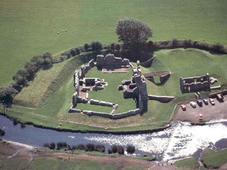
The historic landscape area of Ogmore comprises the low-lying river terrace at the junction of the Ogwr (Ogmore) and Ewenny rivers. The area includes 2 enclosures contained within the registered park and garden of Merthyr Mawr, which lies on the opposite side of the Ogmore River (see HLCA 012) notably Coed Pwll-y-fflew and Waun-y-fervill (only the latter formed part of the Merthyr Mawr Demesne land in 1813. HLCA 018 is based around the shrunken settlement of Ogmore. The medieval and early post-medieval settlement at Ogmore originally comprised a nucleated grouping; prior to the Glyndwr rebellion the settlement comprised 22 tenants and 27 cottages, the rebellion reduced it to six tenants. The settlement remains as a farm, Ogmore Farm and a small hamlet to the south of the Castle.
The castle of Ogmore (SAM Gm 037) was originally constructed c 1100 by William de Londres; the primary castle was an oval ringwork with attached D shaped bailey to the west. The masonry defences date from the 12th and 13th centuries most significant is a 2-storey rectangular Keep (early 12th century, later heightened), probably one of the earliest Norman buildings in the region, the rectangular cellar and the a curtain wall and gateway (13th century) with parallels at Coity and Newcastle. The outer bailey contains the courthouse (14th /15th century), a structure where manorial courts were held until the early 19th century.
Historic Landscape Characteristics
Ogmore, is characterised as an area of enclosed generally low-lying land at the confluence of the Ogmore and Ewenny Rivers, largely typified by water meadow land liable to flooding, but including the small area of the enclosed Flemings Down with its Iron Age promontory Fort (SAM Gm 466). The concentration of settlement is found at the village of Ogmore with its strategically placed medieval Castle, the centre of medieval Lordship. The settlement is characteristically a nucleated organic cluster of farms/cottages (including public house, the Pelican Inn, on the 1st edition OS 1884) centred on castle. Characteristic; medieval/post-medieval vernacular buildings/regional houses are represented by Ogmore Farm, Ogmore Cottage and Ty-maen, the latter a regional house with chimney backing on entry and outside cross passage.
The agricultural landscape has an evolved, and varied field pattern of small to large enclosures, with some indications of medieval strip fields surviving and is characterised by varied, yet distinctive boundaries. An area of Ancient woodland (Kings Wood) survives at the foot of Flemings Down.
The area is an important multiperiod relict archaeological landscape of considerable time depth and variety including: prehistoric, medieval and post-medieval settlement/fields, a medieval shrunken/deserted village. The area is dominated by military/defensive features including prehistoric promontory fort and medieval Castle (Ogmore), and has also been considered the possible site of Roman fort (the illusive Bomium), as yet unproven.
The location of early medieval slab cross and inscribed stones found at Ogmore castle suggest some former ecclesiastical function/importance; the Vervil boundary dyke (SAM Gm 465), nearby also indicates territorial boundaries dating to at least the early medieval period if not earlier. The area has characteristic features (eg a medieval weir and the system of leats and a millrace at Ogmore Corn mill) associated with rural industry: mostly associated with milling, including fulling (14th century) and tidal mills, sawmill, limekilns are also indicated. The area is also characterised by numerous features connected with transport and communications, including the possible Roman/medieval Road Heol-y-milwyr, footpaths, tracks and both winding and straight lanes. A variety of river crossings/fording points including the ancient stepping stones (SAM Gm 184) at Ogmore Castle and a number of interesting bridges such as the striking late 16th or earlier four-arched New Inn Bridge, the New Bridge of 1827, and a steel cabled suspension footbridge of 1840 (all Grade II Listed) are characteristic of the area (and the adjacent HLCA 013).