Gelligaer
002 Capel Gwladys Open Common
HLCA 002 Capel Gwladys Open Common
Relict agricultural landscape; early church enclosure and archaeological remains; Roman military installations. Back to Map
Historic Background
The historic landscape character area of Capel Gwladys Open Common is characterised by its gently rolling plateau and wide terraces of unenclosed and unimproved upland moorland, covered in some areas with dense bracken and reeds. The terrain, which contains no hedgerows or occupied buildings, falls gently from the north towards the south-east and drains into Nant Bryncanol. It is currently used for rough pasture, grazed by sheep and mountain ponies and public 'pleasure' pursuits, several of which pose a threat to the historic fabric of the area.
On the north-eastern side of the area a relict archaeological landscape of former enclosed arable fields with ridge and furrow, hollow-ways and settlement evidence has been identified during fieldwork. The documentary evidence and the remains suggest a medieval or early post-medieval date for this activity, which may be associated with the documented demesne manor of Eglwyswladus. The nearby farm place-name of Maerdy (in HLCA 004) supports this view. Small scale quarrying is evident in the northern part of the area.
The area is marred by the wide scar of green improved pasture, resulting from a gas pipe-line, which was installed in the 1980s and proceeds northwards over the rest of the Common from the western fringe of this area.
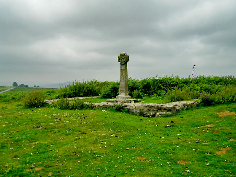
The most dominant landscape feature, both visually and spiritually, of this area are the remains of the church site of Capel Gwladys and its associated features, which are today marked by a standing cross. The site, significantly near a Roman road, is referred to in the 12th century Life of St Gwynllyw in a context that implies that it was of some antiquity at that date. The remains consist of the dry-stone foundations of the rectangular church (40' by 19'), comprising western tower, nave and chancel, set within an enclosure. A rough cross slab with incised ring-cross was found at the site in 1906 and probably dates to the 8th or 9th century. It is preserved in the porch of the later parish church at Gelligaer. An outer enclosure, comprising a dry-stone wall perimeter, may have contained the settlement associated with Capel Gwladys.
The area also preserves the significant remains of at least four small Roman military installations that are usually considered to be practice camps. These are small rectangular enclosures of varying size, having banks and ditches, with one at least showing signs of a distinctive internal clavicular gateway. Whilst the generally accepted interpretation may be correct it is worth noting that all these enclosures are visible from and to the fort, lie grouped in a distinct arc and provide clear vistas to the north-east and north-west that the fort at Gelligaer does not possess. They may therefore be considered to be part of the early Roman military deployment of the area providing important lines of sight from the fort and the means of signalling. Whatever their function these earthworks are clearly significant elements in the historic landscape.
Historic Landscape Characteristics
The area of open common-land is dominated archaeologically, culturally and visually by the remains of Capel Gwladys, which probably has early medieval origins. A number of Roman practice camps add military interest to the area and links to the forts in Gelligaer Historic Settlement (HLCA 001) in the south. Fieldwork has discovered an extensive relict medieval landscape of considerable importance, especially as it may be associated with the documented demesne manor of Eglwyswladus.