Clydach Gorge
006 Darrenfelen and Cwm Dyar-fach Enclosed Upper Valley Side
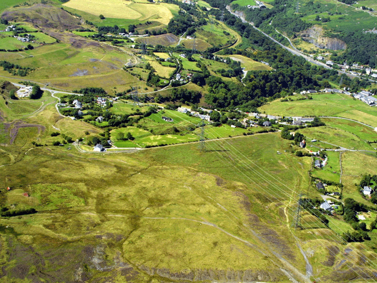
HLCA 006 Darrenfelen and Cwm Dyar-fach Enclosed Upper Valley Side
A mixed dispersed industrial/agricultural settlement landscape; industrial settlement with squatter origins; industrial housing predominantly short rows; industrial rail/tramroad features and bridges; pre-industrial buildings and associated regular field pattern of medium-sized fields; distinctive field boundaries; prehistoric settlement (hillfort).Back to Map
Historic Background
The historic landscape area of Darrenfelen and Cwm Dyar-fach Enclosed Upper Valley Side is an area of scattered settlement and smallholdings, which has been augmented by industrial housing and later 20th century housing estates. Like HLCA 005 the earlier pattern of enclosed land along the margins of the open mountain of Llanelly Hill has been preserved in the later settlement pattern; the industrial miner's settlement (late 18th /early 19th century) situated on the unenclosed land, and along the roadside in predominantly ribbon fashion. The scattered nature and location of the industrial settlement hints at squatter origins, and reflects probable earlier agricultural traditions of encroachment on the unenclosed common.
The area is traversed by both the Llam-march Tramroad (1794-5) and Bailey's Tramroad; there are a number of interesting features associated with these: the stone bridge abutments of the Llam-march Tramroad bridge; Cwm Llam-march Bridge, a stone bridge/culvert carrying Bailey's (Govilon) Tramroad over Cwm Llam-march; and Cwm Nant-Gam Bridge, a stone bridge/culvert constructed in 1822, which carried Bailey's Tramroad from Gellifelen Colliery to Clydach Ironworks. The route of the former Blaenavon 'stoneroad' c1799 (SO 224121 - 239120) which provided a link from the top of the Llam-march line over to Blaenavon, falls within the area; this was abandoned from 1812 when the Clydach Ironworks began to use the canals between Gilwern and Newport. There was a later link to the 1811 inclines serving the Clydach Ironworks (from SO 222122).
Historic Landscape Characteristics
Darrenfelen and Cwm Dyar-fach Enclosed Upper Valley Side is characterised as an area of mixed dispersed settlement including areas of ribbon and isolated terraced rows. The settlement pattern has a haphazard arrangement, which is dominated by broken areas of ribbon development; the overall effect is to preserve an unplanned feel of small isolated clusters, with neither definite nucleation nor plan, which perhaps reflects the settlement's squatter origins.
The area's housing stock varies from single cottages to larger villas, however short rows of double-fronted two-storeyed terraced workers' cottages predominate, mostly heavily altered, although some good examples survive (eg Penllwyn). A few examples of pre-industrial buildings survive such as the barn at the Jolly Colliers, probably of 18th century date and a possible Long house at Penffyddlwn (with some 19th century rebuilding), set within the surviving pre-industrial enclosed land. The other dominant forms are the area's non-conformist chapels, which include Bethel Independent Chapel (1896, rebuilt 1903), Beersheba Baptist Chapel (1842, rebuilt 1902), Carmel Calvinistic Methodist Chapel (1842, rebuilt 1902), all at Darrenfelen, and the Gellifelen English Methodist Chapel (1829, rebuilt 1902). The area has a school, post-office and Mission room.
The common characteristic of industrial transport network is continued here with features, primarily bridges associated with the Llam-march Railroad and Bailey's Tramroad, among others, which traverse and divide the landscape.
A further site worthy of mention is Clydach Camp or Twyn-y-Dinas, an Iron Age hilltop settlement or hillfort (PRN 2474), which like its northerly counterpart at Craig-y-gaer (HLCA 001b) has suffered from quarrying activity, indicated by the remains of limekilns nearby.
The boundary area between HLCA 006 and HLCA 005 forms part of the Cwm Clydach SSSI.