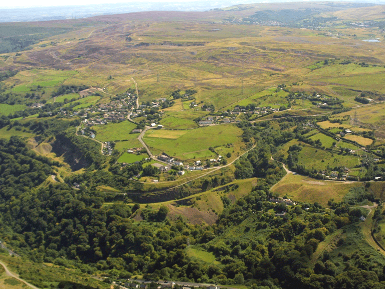
Clydach Gorge
004a Cwm Clydach Transport Corridor and 004b Darren-Ddu/Blackrock Transport Corridor
HLCA 004a Cwm Clydach Transport Corridor and HLCA 004b Darren-Ddu/Blackrock Transport Corridor
Transport corridor (industrial and public), rail and road with associated features including bridges; quarries and limeworks; water supply features; upland pre-historic settlement (hill fort); varied agricultural enclosure and scattered post-medieval agricultural settlement and isolated short rows of industrial housing; Ancient Woodland.Back to Map
Historic Background
The historic landscape areas of Cwm Clydach Transport Corridor and Darren-Ddu/Blackrock Transport Corridor comprise the deeply entrenched valley of Cwm Clydach which forms a natural route corridor between the mineral-rich uplands of the Blaenau and the Usk Valley. The area, largely within the Mynydd Llangatwg SSSI and Cwm Clydach SSSI, is dominated by communication routes, including road, railroad and tramroad, developed initially to service the industry of the surrounding area and later the valley itself. Initial transportation in the area would have been by pack-horse, however between 1793-5 the Clydach Railroad was constructed (HLCA 004a), followed closely by the Llam-march Railroad of 1794-5 (HLCA 004a). Other routes in the area include the Llam-march Tramroad of 1809 (HLCA 004a), the Merthyr-Govilon Turnpike Road of 1812-13, Bailey's Tramroad of 1821 (HLCA 004b), the Merthyr Tredegar & Abergavenny Railway (M T & A) of 1862 and finally the Heads of the Valleys Road, completed in 1962 (the latter two both within HLCA 004a).
The Clydach Railroad, currently the minor road (SO 245148- 241159) was built to link the Forge at Glangrwyney with the canal wharf at Gilwern, via Gelli-Felen Collieries and Pont Harry Isaac, an extension to Beaufort was built slightly later. The line from Gilwern to Glangrwyney was transferred to the Breconshire Turnpike Trust in 1839. The first part of the railroad was constructed with iron sleepers, by 1794, 6792 of these had been laid, there after a decision was made to use wooden sleepers. In 1836 the original sleepers were replaced in stone, some of which remain visible to this day. A scheduled section of the Clydach Railway lies near Brynmawr at SO 202122 (HLCA 004a; MM263 (BLG)).
The Llam-march Railroad provided the original route by which materials reached Clydach Ironworks from the mineral holdings at Cwm Llam-march and Gellifelen, later supplemented by inclines, the route was converted to a tramroad in 1809 and extended to a wharf at Gilwern under the Brecknock & Abergavenny Canal Act.
Bailey's Tramroad (SO 197123 - 201159), was built c1821-30, and linked Nantyglo Ironworks with Llangattock Quarries, the route is now a tarred road, delineating the northern extent of the historic landscape and offering good views of the Clydach Valley.
The standard gauge line of the MT & A was opened as far as Brynmawr by 1862, partly utilising the route of Bailey's Tramroad, and at first leased to and then taken over by the London and North Western Railway in 1866, and passed to the LNS in 1923. The route, now disused, was instrumental in breaking the monopoly of the Great Western on the South Wales run. An impressive viaduct, Nant-y-Dyar Railway Viaduct (Listed Grade II; HLCA 004a), remains to the north of the Clydach Limeworks (HLCA 007).
Apart from transport networks the main characteristic of the areas are limestone quarries, in particular Llanelly Quarry (HLCA 04a; SO 222124) and Black Rock Quarry (HLCA 004b; SO 213125). Llanelly Quarry originally supplied Clydach Ironworks with limestone for flux, and was also successively supplying roadstone, as well as lime for agricultural and building purposes. As quarrying proceeded, it cut away the lower part of a second incline, which had been built in about 1811 to supplement the capacity of the Llam-march Railroad. The remains at the site include a double limekiln at the entrance, and there is a second pair (inscribed 'GP 1892') near the railway siding of the MT & A Railway, and concrete bunkers in which roadstone was stored.
Black Rock Quarry was also established early in the industrial development of the valley and limekilns are known to have stood here in 1795. A branch from the Clydach Railroad served the quarry via an arch (now destroyed by the Heads of the Valleys Road) under the 1812 turnpike; this line continued in use until about 1908. Lime transported in wooden box wagons capable of carrying c6 tons, while coal for the kilns came from Brynmawr via the Clydach Railroad.
'Block stone' was also taken by the railroad to the canal at Gilwern for distribution beyond where it was used as road stone. Black Rock Stone Products Ltd. started crushing here in 1939. The current extent of the quarry is the result of the demand for roadstone in recent years, and is jointly owned with the Black Rock Limeworks. During the Second World War Black Rock Limeworks started burning limestone again under the Graig-y-Gaer Limestone Quarries Ltd.
The other industrial remains in the area are those of the Clydach Colliery (SO 201122), which date from before 1812, with its level entrance (Clydach Coal Level MM264 (BLG), re-constructed when the MT & A Railway was built over the site.
Historic Landscape Characteristics
Cwm Clydach Transport Corridor and Darren-Ddu/Blackrock Transport Corridor are characterised chiefly by their industrial and other transport links, which have developed mainly since the late 18th century, primarily represented by the Clydach Railroad and the Llam-march Railroad/Tramroad. These transport features use a route corridor already extant since prehistoric times. This is evident from the location of the two hill forts Twyn-y-Dinas (HLCA 006) and Craig-y-Gaer Camp (HLCA 004b; PRN 2499) between the upland pastures (and mineral wealth) of the Blaenau and the low-lying fertile agricultural valley of the Usk to the east. The route impinges over a variety of earlier agricultural landscapes, which are secondary to the overriding communications/transport characteristic.
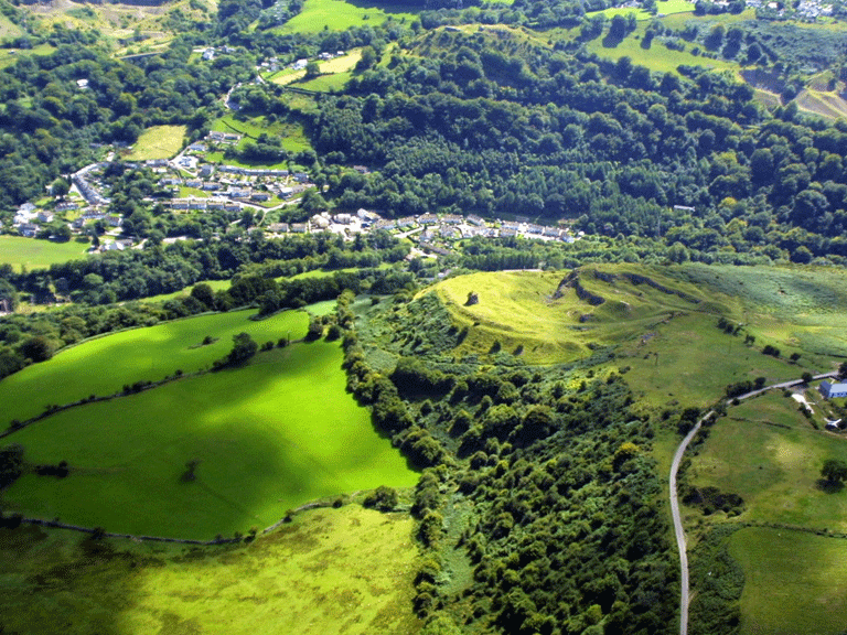
The other dominant visible characteristic of the landscape area is provided by extensive quarrying for limestone (construction and road surfacing) and for the production of lime for industrial, domestic and agricultural purposes, and spans the period from the late 18th century to the mid/late 20th century.
Other characteristics include leats and other water-supply features and scattered settlement features associated with the Clydach Ironworks and the furnace and forges of Llanelly north of the Clydach. The highly visible quarry at Craig-y-Gaer is also the site of an Iron Age hillfort, the remains of which have been extensively quarried.
The area has extensive tracts of re-generated ancient woodland, which form part of the Cwm Clydach National Nature Reserve, and Cwm Clydach SSSI; the area also takes in part of the Mynydd Llangatwg SSSI, and all the Brynmawr Sections SSSI.