Down in the flood
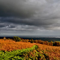
Around the coast of South Wales a whole series of prehistoric landscape drowned by rising sea levels are now only visible at low tide. The largest and best-studied area is on the Gwent Levels, followed by Swansea Bay, with smaller areas in some of the sandy bays elsewhere, particularly around Gower. Sea level rise has not been constant, at times it has gone into reverse. In some cases this may have been at least partly due to dunes building up, raising the level of the ground and interfering with the drainage of the land behind them, causing the ground level to rise again as the peat built up as for example we can see happening today at Oxwich or Crymlyn Burrows.
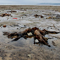
At Uskmouth, footprints made by three adults and a child were found in the 1980s in an area that is now covered by the sea at high tide but would then have been coastal marshland. They were dated to the Mesolithic period by the peat that had developed over them. A mattock made from a reindeer antler came from close by. Other Mesolithic remains came from the Goldcliff area, including charcoal and tools and the bones of deer and pig. There were also deer hoofprints impressed into the clay below the lowest peats. Goldcliff was covered by alder and birch woodland but were replaced by a more open landscape, where a raised bog started to develop in the Neolithic period.
On most of the coast, the earliest land surfaces we can still see date to the Neolithic period; anything earlier is now below the lowest that the tide ever falls. More human footprints, found below high tide level at Kenfig at the south end of Swansea Bay, have been dated to the Neolithic period.
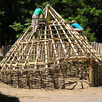
With the Bronze Age, the remains of buildings start to appear on the Gwent Levels, both circular in shape, which is what we normally find in the Bronze Age, and rectangular which was completely unexpected. Roundhouses have been found on Rumney Great Wharf and the intertidal area near Chapel Tump and Collister Pill at Magor, dating to the Late Bronze Age. The finds from these suggest that they were houses for people. At Redwick up to five long narrow rectangular buildings were found, their outlines marked mainly by rows of posts. Hoof-prints show that cattle were being herded there, Only one of them had traces of burning that might indicate a hearth. One of the advantages of the huge areas of foreshore that are left uncovered in at low tide in the Severn Estuary is that we are able to see the entire landscapes in which people lived and worked. By the time the buildings were put up at Redwick the area had developed into were raised bogs where the peat continued to form when the buildings were in use. Further inland, in what is now Caldicot, there was a lot of activity around the River Nedern, although the exact nature of the site is not entirely clear.
Bronze Age and Iron Age trackways have also been found in Swansea Bay, but the best of the Iron Age archaeology also comes from the Severn Levels. Rectangular buildings have been excavated at Goldcliff, [LINK to image on Houses pages] along with no fewer than eighteen trackways. None of the buildings has any evidence for hearths, and the environmental evidence from them suggests that they were used for cattle, possibly grazing the saltmarshes seasonally in the summer. The same thing seems to have happed further round the coast in Swansea Bay at Kenfig, although here we do not have the byres in which the cattle were kept. As more and more deposits are uncovered by coastal erosion, we are learning more and more about life in prehistoric South Wales.
View our 3D models of the prehistoric trees at Whiteford Point, Gower


Themes
Hearth and home Very little evidence has been found so far in South Wales for where people lived throughout most of prehistory. Learn More
Every path tells a tale Prehistoric people, much like varying cultural groups all over the world today, understood the world in different ways. Spirituality and the inanimate world were intertwined in their daily life. Learn More
Down in the Flood Around the coast of South Wales a whole series of prehistoric landscape drowned by rising sea levels are now only visible at low tide. Learn More
The importance of things Throughout prehistory, artefacts and the technology that created them, have figured prominently in explanations of culture process and culture change. Learn more
About the project
Since the 1980s, we have received grant aid from Cadw to carry out a series of projects looking at the prehistoric archaeology of Glamorgan and Gwent. Some of them were survey projects, looking at the information available on a wide range of different monument types as part of a pan-Wales study aimed at improving protection. Others were locally focussed, and took place in response to a specific threat to a site or group of sites. Before new Planning Guidance was published 1990 (PPG16), these excavations included sites that were under threat from development, but if such project are carried out today, it would be the developer who would be liable for the costs. Cadw still grant-aids rescue excavation of sites that are being destroyed by natural processes, such as coastal erosion.
Please see here to find out more about us, our activities and our forward strategy