Historic Landscape
Characterisation
Merthyr Tydfil
006 Merthyr Tydfil, South: Plymouth Street Area
HLCA 006 Merthyr Tydfil, South: Plymouth Street Area
Industrial settlement: early ribbon development with later regular terraced
infilling; transport corridor and close association with neighbouring
areas
Click here for a
character area map
(Photo: GGAT Merthyr 006)
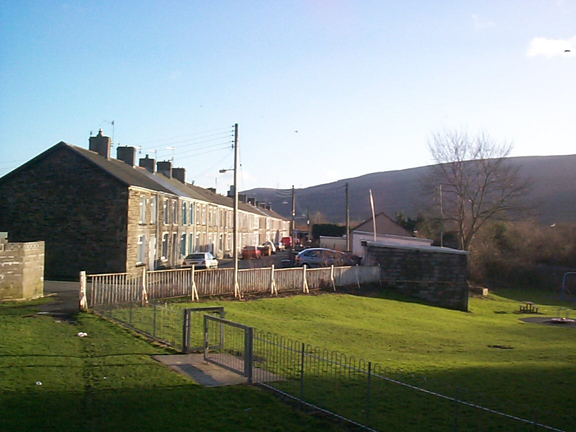
Merthyr Tydfil, South: Plymouth Street Area character area: industrial
settlement based on ribbon development.
Summary
The origins of this industrial settlement lie in the early 19th century as a ribbon development along the toll road east and west of Upper Plymouth Street, and it continued to expand as a ribbon development along other lies of communication, the Plymouth Toll Road and the tram and rail networks. Ribbon development continues to be one of the main visual impressions to the present day, supplemented by later regular terraces.
Historical background
The historic landscape area of Merthyr Tydfil, South: Plymouth Street Area developed initially during the early 19th century in ribbon fashion along the toll road, ie east and west of Upper Plymouth Street. By 1836 the area comprised ribbon development to both sides of Plymouth Street up to the area of the present-day Warlow Street, and rows in the area to the west of the Merthyr (Penydarren) Tramroad. Also extant by this date was the Plymouth Tollroad, the Ebenezer Baptist Chapel, and the Bell Inn. Gardens were located between the Street frontage and the Plymouth Feeder Canal. Plymouth House (Plymouth Cottage) had been constructed, as had the office to the south. The development of the area was directly linked to that of the areas lines of communication: the Plymouth Toll Road, created under the auspices of the Glamorganshire Turnpike Act of 1771 and instigated by Anthony Bacon; and later the emergence of tram and rail networks, notably the Taff Vale Railway (1841). Though the earlier street pattern remained much as before between Penydarren Railway and the Plymouth feeder, by 1879 the area was transected by Vale of Neath Railway (1853) and the Dowlais Railway incline (1851), while to the south of the Dowlais Railway incline, Railway Terrace and Mary Terrace were under construction. The proximity of the area to major rail links was reflected by the addition of the Maerdy Hotel, next to Dowlais Railway. Further minor additions occurred adjacent to the Taff Vale Railway by 1905. Primarily an additional terrace to south of Railway Terrace on Plymouth and Clare Streets, in the area between the two railways to the south west of the Plymouth feeder. Development continues during the early 20th century and by 1918-19 further terracing had been completed on the east side of Plymouth Street, while Ernest Street had been constructed between the back of Plymouth Street and the feeder. To the north of Plymouth House, Melbourne Terrace had been constructed, as was the Merthyr Tydfil Corporation's Isolation Hospital. The Mine Office below Plymouth House was apparently derelict by this time, the adjacent works (HLCA 019) having closed in 1880.