Historic Landscape
Characterisation
The Rhondda
033 Rhondda Fawr: Enclosed Valley Sides
(Cwm Lan - Nant-y-Gwiddon)
HLCA 033 Rhondda Fawr
Largely relict medieval/post-medieval agricultural landscape; distinctive
field boundaries; prehistoric funerary landscape and settlement; upland
medieval agriculture and settlement; post-medieval agriculture and farmsteads
(predominantly longhouse regional types); documentary evidence for both
medieval/post-medieval agricultural practice and settlement; extensive
industrial landscape with features dating from the early phases of mineral
extraction.
Click here for character
area map
(Back to map)
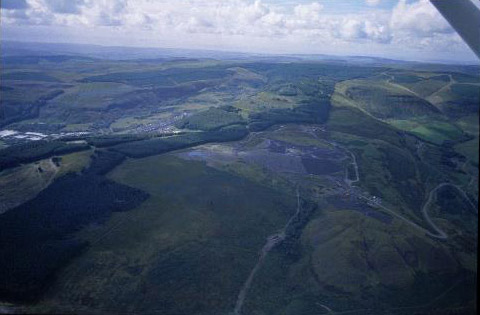
(Photo: GGAT HLCA033)
Former enclosed landscape on slopes of Mynydd y Gelli and Llwynypia Mountain
The historic landscape area of Rhondda Fawr: Enclosed Valley Sides (Cwm Lan - Nant-y-Gwiddon) is a detached extension of HLCA 029 Rhondda Fawr: Enclosed Valley Sides. Apart from agriculture, industrial land use is indicated, particularly along the lower lying eastern boundary of the area; these are primarily coal extraction sites, such as Bwllfa Levels, Bwllfa Eastern Pit, Maendy Pit with its engine house (1st edition 1884), Ton Pentre Colliery and Gelli Colliery.
Finds from the area include a Neolithic stone axe and a Bronze Age arrowhead from Mynydd y Gelli and a hoard of bronzes from the quarry at Gelli. The area contains important examples of Bronze Age funerary monuments, of particular interest is the cairn field on Mynydd Gelli (SAM Gm 354), which includes larger ring and kerb cairns. Other funerary monuments and a prostrate stone are to be found in the vicinity. A further cluster of funerary monuments is located at the north of the area, these include a robbed ring cairn northwest of Tarren Felen-uchaf, three cairns on Mynydd Maendy and another southwest of Maendy Camp, which when excavated in 1901 produced a damaged bronze dagger, pottery, including sherds of cinerary urn and flints. Scattered over the end of the spur of Maendy Camp is a cairn field, comprising nine small mounds, and a larger cairn; situated within this group is a possible cooking, or burnt mound (Arch. Camb. 1902, p. 258), also dating to the Bronze Age. Prehistoric settlement in the area includes the remains of late Iron Age/Romano-British round houses at Hendre'r Gelli, from which pottery of 2nd and 3rd century date has been recovered, indicating continuity of use into the Roman period; a multitude of other features, including field systems are also known for the area.
The two disparate platform huts on Mynydd y Gelli, and the large platform house in Cwm Lan, set on the northeastern flanks of Mynydd Ton illustrate continuity of settlement within the uplands into the medieval period.
A small amount of modern forestation has occurred within the bounds of the HLCA, which contains small remnants of ancient woodland; Coedcae field names and the existence of charcoal burning platforms, such as that on Mynydd Bwllfa, testify to the formerly more extensively wooded nature of the area. During the post-medieval period the farmhouses of the area are typically of the longhouse type, e.g. Gelli farm (hearth-passage group: long-houses, RCAHMW).