Historic Landscape
Characterisation
The Rhondda
031 Rhondda Uplands
(Mynydd Ton - Mynydd Penygraig)
HLCA 031 Rhondda Uplands
Upland mountain sheepwalk, partially forested; multi-period and multi-functional
landscape; prehistoric settlement and funerary landscape; early communication
corridor; military structures; early medieval administrative boundaries;
medieval upland settlement; post-medieval industrial landscape; relict
upland agricultural landscape; documentary and place name evidence.
Click here for character
area map
(Back to map)
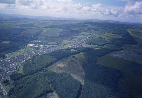
(Photo: GGAT HLCA031)
Aerial view of uplands above Cwm Clydach, showing twentieth century afforestation.
The historic landscape area of Rhondda Uplands (Mynydd Ton - Mynydd Penygraig) is a southerly extension of HLCA 030 Rhondda Uplands. Similarly the dominant character of the landscape is that of unimproved, common upland sheepwalk, where coarse grasses and sedge vegetation predominate, a significant proportion of which has been turned over to forestry with large plantations of spruce, fir predominating, and occasional stands of larch. The terrain is characterised by gently sloping summits, bordered by craggy cliffs and steep wooded slopes. Apart from agriculture, some minimal industrial land use is indicated; this is principally represented by coal pits in Cwm Cesig and on the north flank of Mynydd Penygraig and also coal tips on Mynydd Pwllyrhebog and in the area north of Gilfach.
The earliest indications of human activity date to the Mesolithic (10000-4400BC), and comprise flint and chert artefacts, these have been found at Gwyneb-yr-haul, Mynydd Ton and Nant-y-gwair. Finds of the Neolithic (4400-2300BC) and Bronze Age (2300-800BC) have also been recovered from the area. A number of important archaeological remains of the prehistoric and Roman periods are situated within the area; these include burial cairns of the Bronze Age, such as Carn Fawr, Carn Fach, the cairn and cist on Mynydd Penygraig and the cairn group on Mynydd Ton. Settlement appears to be continuous with occupation spanning both the Iron Age and the Roman period (800BC-AD410) here represented by the fortified hill top settlement of Maendy Camp (SAM Gm 99) on Mynydd Maendy overlooking Cwm Parc to the north and the nearby settlement of Hendre'r Gelli, just outside the area. Maendy Camp is rare example of an Iron Age hillfort in the Glamorgan uplands; the site excavated in 1901, is characterised as being of a 'pastoral' type, its layout comprising a small horseshoe-shaped central enclosure enclosed by widely spaced low outer banks. A Bronze Age cairn is situated between the inner and outer ramparts.
During the medieval period, settlement and use appears to have been similar to that of HLCA 030 to the north; upland settlement of the period is typified by platform houses, examples include those at Cwm Cesig, above Ton Pentre and at Nant-y-Gwiddon. Medieval trackways are also preserved in the landscape, such as that at Tarren-y-Bwllfa, Cwm Clydach. The area, together with the now urbanised areas of neighbouring Cwmparc and Treorchy contained the most extensive area of demesne land in the Lordship of Glynrhondda, centred around Ystrad Fyrchan farm and Tir Cadogan (later Pentwyn and Tir Gibon Dio), namely that associated with the Cadwgan family during the mid-16th century; the importance of the family is emphasised in tradition, the contemporary poet Dafydd Benwyn composed elegies to three of the family, which died out in 1585. Documentary and cartographic sources, supported by place-name evidence, offer an insight into the organization of the pre-industrial agricultural landscape of the area; recalling the exploitation of the uplands, often on a seasonal basis, for cattle, and later sheep, farming during the medieval and post-medieval periods.
Other influences on the landscape date to the 19th and 20th century industrial exploitation of the area; these include relatively minor features, mostly coal levels, trial levels and small areas of tipping and airshafts to the numerous underground workings.