Historic Landscape
Characterisation
The Rhondda
009 Ystrad and Pentre
HLCA 009 Ystrad and Pentre
Mid-19th century 1st phase linear roadside development spreading south
from a nucleus at Pentre, serving a number of collieries; later 2nd phase
expansion on linear grid layout, specifically at Pentre and Bodringall
(Ystrad); continuous residential village with low urban morphological
and functional development; early centre of non-conformist religion; cultural
and historic associations.
Click here for character
area map
(Back to map)
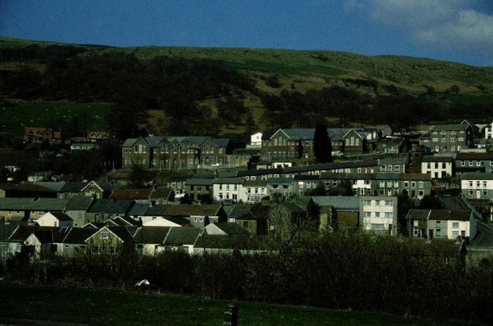
(Photo: GGAT HLCA009)
Ystrad, view from south showing the late 19th century schools, centre.
The historic landscape area of Ystrad and Pentre originated as a linear ribbon settlement along the main road through the Rhondda Fawr during the 1860s. Prior to urban/industrial development the area was held by five different estates, with no single dominant interest; the settlement eventually expanded to take the low lying pasture of Ty-isaf, Tyr Melin-yr-Om, Ty'n-tyle, Gelli Dawel and Bodringyll farms (Tithe plan and apportionment for Ystradyfodwg, 1844). The area figures prominently in the early history of non-conformity in the region with the construction in 1786 of the Ynysfach Baptist Meeting House, later renamed Nebo, at Heolfach (Lewis 1959). Also of the areas pre-industrial past is the old mill depicted on both the Tithe map and the 1st edition 6-inch OS map, that of Melin-yr-Om, the mill associated with the Cistercian grange of Llantarnam at Mynachdy Penrhys.
Three collieries were located close to the area, Bodringallt, Pentre and Ty'n-y-bedw (neighbouring area HLCA 011) collieries. Bodringallt Colliery was sunk in 1864 by Warner Simpson and Company and produced over 34,000 tons of coal within its first year. Following its purchase in 1890 by David Davies and Sons, Ferndale renamed Ferndale No. 3 Colliery. This colliery closed in 1959, and its site cleared and landscaped. The brick works at Bodringallt, also worthy of note, became the second largest producer of bricks in the Rhondda after Llwynypia, exporting throughout the South Wales Coal Field for walling shafts, and the construction of colliery buildings and houses (Carpenter 2000). Pentre Colliery was sunk after Edward Curteis leased the mineral rights to land at Pentre in 1857; by 1864 shafts had been sunk to the deeper seams. The main period of expansion was between 1874 and 1884 when output trebled from 59,000 tons to 159,000 tons under the ownership of the Cory Brothers of Cardiff, who had bought the colliery in 1861. A gas explosion in 1871 resulted in the death of thirty-eight miners. The colliery closed in 1929 and was subsequently landscaped and is now used for recreational purposes
The development of the area was without doubt encouraged by the construction of the Taff Vale Railway line; in 1858 the Taff Vale Railway decided to build a station at Ystrad and by 1861 the line was open for passenger services. The tramway connecting Bodringallt Colliery with the Taff Vale Railway was a prominent feature of the landscape during the 19th century (1st edition 6-inch OS map 1884, surveyed 1875 and later editions). Later other transport systems developed to serve the area's ever-increasing population; these included a system of horse drawn omnibuses during the 1870s and even electric tramcars by 1908.
By 1875 the ribbon-like kernel of the settlement is in place along the main road (i.e. Ystrad Road, Llywellyn Street and Carne Street); at Pentre the ribbon development has already expanded to form a planned grid layout of terraces, including Albert Street, Queen Street and Treharne Street among others. In addition to the colliery, brickworks and terraced housing at Pentre, the 1st edition map details Pentre House; a vicarage; two schools; two Methodist Chapels (Primitive and Weslyan), at least five hostelries including the Bailey Arms, the Griffin Inn, the Llywlyn Arms (PH), Pentre Hotel and the Woodfield Hotel with its Brewery. Ystrad at the time consists of Arthur Street, Bodrhyngallt Cottages, Church Row, Copse Row (Gelli Dawel), Gelli Cottages, Heolfach, and Primrose Hill. The settlement has schools; three Inns the Kings head, the Lamb, and the Railway; a gas works, the Ystrad Gas Works; and Ystrad Station (1st edition 6-inch OS map 1884, surveyed 1875).
Over the following twenty years the settlements at Pentre and Ystrad both expanded. At Pentre this occurred chiefly in the area south of Albert Street, including John Street, Raglan Street, and Robert Street and east of Ty'n-y-bedw Colliery, including Margaret Street and Fir Grove with the extension of the pre-existing street grid. St Peters Church built by FR Kempton in the Early English style, in 1887-90 at a cost of £20,000, the Rhondda Engine Works and additional schools also date to the period. At Ystrad the development, including Gelligaled Road, is similar though less extensive. Much of the housing development during this phase was carried out for building-clubs of colliery workers, the remainder being carried out as speculative ventures for property investors. An example of the former being Redfield Street, where a club established in 1884 built 26 three-bedroomed houses in the traditional style. Penrhys Road is improved with additional terraces built along it, and the church of St Stephen, (by EM Bruce Vaughan in the Early English style, 1896) erected, while the Rhondda Fever Hospital, later extended and renamed the Ty'n-tyle Isolation Hospital, also dates to this time (2nd edition 6-inch OS map 1900, revised 1897-98). A direct relationship between the fortunes of Pentre Colliery, which reaches its peak output in 1884, and the expansion of settlement of Pentre is seen. The rate of housing development appears to diminish in the following period with minor expansion south and north of Pentre, and in the formerly open area between Ystrad and Llwynypia, to the south. The only notable additions to the urban landscape at both Pentre and Ystrad during the period were further schools and the generous provision of allotment gardens (1921 edition 6-inch OS map, revised 1914).