Historic Landscape
Characterisation
The Rhondda
003 Penygraig
HLCA 003 Penygraig
First phase pithead colliery settlement with earlier nucleated
origins, later industrial ribbon development and late 19th century imposed
grid-layout; retains typical terraced housing, commercial properties and
chapels; early council housing; moderately developed commercial centre;
cultural/historical associations.
Click here for character
area map
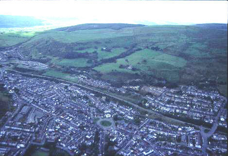
(Photo: GGAT HLCA003)
Aerial view of Penygraig from the north-west with Mynydd Penygraig in
the background.
The historic landscape area of Penygraig comprises an industrial settlement, which originated as a small group of cottages, a shop and chapel with burial ground, adjacent to Ffrwd Amws House. This embryonic settlement is located partly on land of the Dunraven Estate and partly on land belonging to Lewis Edwards and George Gething within the parish of Ystradyfodwg near the boundary with the parish of Llantrisant (Tithe map of Ystradyfodwg 1844). The earliest industrial terraced housing at Penygraig was Whiterock Row and Tai Row (demolished by 1915) in the area northwest of the recreation ground. These houses, described as 20 Workmen's Houses & Gardens on the Tithe map of Llantrisant (1842), are situated on part of the landholding Dinas Uchaf Farm within the neighbouring parish of Llantrisant and were in the ownership of Walter Coffin, the coal entrepreneur; it is this holding which is extensively developed after 1875 to form the communities of Penygraig and Williamstown (HLCA 004).
The area is strongly associated with the activities of Moses Rowlands of Penygraig, a local mining engineer; in 1857/8 in partnership with Richard Jenkins, geologist, he opened Penygraig Level. In 1864 the Penygraig Coal Company, (Moses Rowlands and Partners) sunk the Penygraig Colliery; six years later the colliery had an annual output of c. 100,00 tons, the mine closed in 1919. The Naval Colliery Company, founded by Moses Rowland and William Morgan in 1875, sunk the Pandy Pits or Adare Colliery, reaching the main coal seams in 1879. This colliery was the site of two gas explosions, the first in 1880 resulted in the death of 101 miners, the second in 1884, when 14 miners and officials died. In 1887 the company was sold and renamed the New Naval Collieries Company and three new collieries were opened in the area: the Ely (1892), Nantgwyn (1892), and the Anthony (1910). Due to the decline in demand for coal all the pits closed in 1958.
The first edition 6-inch OS map, surveyed in 1875, depicts the emerging settlement of Penygraig, and the catalysts behind its development, namely the Penygraig Colliery with its associated coke ovens south of the settlement and the newly sunk Adare Colliery, later named Pandy Coal Pits (2nd edition 6-inch OS map), to the north. Penygraig is also the terminus station of the Great Western Railway at the head of the Ely Valley and has at least three Inns/Public Houses, a Hotel, two chapels and a colliery school at this date. The pattern of development is predominantly linear roadside or ribbon in nature spreading along Penygraig Road, to either side of the original nucleus. The extent of the settlement at this time is limited again almost exclusively to the land of the Dunraven Estate, in particular the farmland of Hendre Cefn-isaf (Hendre Cafan issaf) and Pentre Cegl (Pentre Cegil) and land belonging to Lewis Edwards and George Gething, Ffrwd Amws Farm, within the parish of Ystradyfodwg. Additionally by 1875 at least three separate groups of terraced housing, Balaclava Row, Mountain cottages, Cross Row and Ty'n-y-cae, and a school had been built on part of the holding Dinas Uchaf Farm within the neighbouring parish of Llantrisant. A rapid process of infilling is well underway by 1898 with regular streets of terraced houses, including Hughes Street and Station Terrace being pushed back from Penygraig Road 1898 (2nd edition 6-inch OS map, 1901, revised 1898). The regularity and the planned nature of the development is particularly visible in the layout of Tyle Celyn and Hughes Street beyond the 1875 settlement limits; here a grid-pattern street layout predominates. The OS plan of 1921 (revised 1914/15) shows the process complete with the settlement more or less as it is today. The first council houses to be built in the Rhondda were constructed at Bransby Street, Millbourne Street, and Aubry Road between 1920 and 1921; the scheme comprised 44 dwellings a reduction from the originally envisaged 160 and construction was carried out by J Thomas, W Pugh, and FG Rideout (Fisk 1995).
There is a typical contrast in the siting and style of the established churches as opposed to the non-conformist chapels, seen elsewhere in the Rhondda. The church of St. Barnabas (1914-15) is high set and in the Early English style, while for example, Soar Baptist Chapel (1902), Classical, is located in the centre of the village.