Historic Landscape
Characterisation
The Rhondda
002 Hafod
HLCA 002 Hafod
Two linear first phase 'pithead' colliery settlements, originating as
a scatter of isolated terraced rows and cottages, ribbon development and
superimposed late 19th century grid-layout; retains typical terraced housing,
commercial properties and chapels; little commercial development; surviving
industrial monuments, Rhondda Heritage Park.
Click here for character
area map
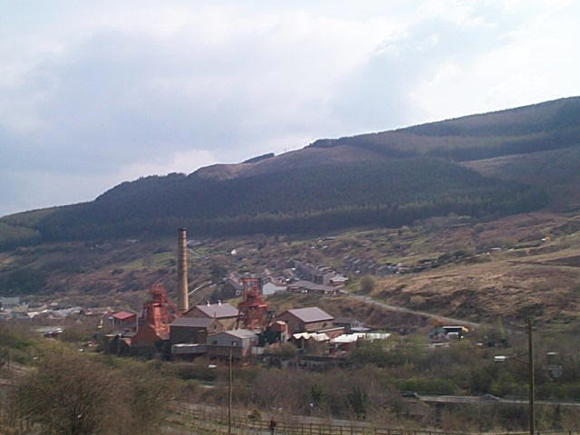
(Photo: GGAT HLCA002)
Rhondda Heritage Park, foreground with part of Trehafod and Mynydd-y-Glyn
in background.
The historic landscape area of Hafod, which takes its name from the nearby farm of Hafod Fawr, initially developed as two small and disparate areas of settlement: Trehafod a linear roadside development and Eirw a linear pithead settlement. These settlements, primarily ribbon development in nature are arranged along Hafod Road (OS 1st edition, surveyed 1875). The area is associated primarily with two collieries, the Coedcae Colliery and coke ovens, and the Hafod Pit/Colliery situated close by.
The impetus for the establishment of the settlement of Eirw was the emergence of the coal industry and the construction of Taff Vale Railway (Eirw and Rhondda Branches). The settlement was established on the west bank of the Afon Rhondda, on pasture belonging to Eirw Isaf Farm some time before the Tithe survey of 1842, when the linear settlement of cottages and houses with gardens and a public house, (the Vaughan Arms on the 1st edition OS 1875) formed part of the estate of Nash Edwards Vaughan. By the survey of the 1st edition 6-inch OS map in 1875 the settlement was centred on the Coedcae Colliery, which had been sunk in 1850 by Edward Mills, and later became part of the Lewis Merthyr Consolidated Collieries (c. 1900). The early core settlement is partly removed by 1898 with the expansion of the Colliery of Lewis Merthyr Consolidated Collieries, though extended to the south with a cohesive but separate block of planned terraces, comprising Bryn Eirw Street, Woodfield and Rheolau Terraces. Little apparent physical development occurs in the following period leading up to the First World War (6-inch OS plan, 1921, revised 1914).
The settlement of Tre-hafod does not appear as a distinct settlement until the latter half of the 19th century. The Tithe map of 1841 shows the area to be relatively poor low-lying riverside land, part of Hafod Fawr farm, then in the ownership of Catharine Morgan (Tenant Lewis Morgan Esq.). The same plan shows three cottages at the mouth of Cwm Hafod, probably occupied by agricultural workers; these appear to have been later removed by the construction of the Taff Vale Railway. The first industrial settlement, depicted on the 1st edition 6inch OS map, surveyed in 1875, is a scattered linear settlement along the main road (Trehafod Road), including Bethel and Gyfeillon chapels, and along a lane leading to the Hafod Pit/Colliery, sunk by brothers David and John Thomas in 1850, purchased along with Coedcae Colliery in the mid-1870s by William Thomas Lewis (later Lord Merthyr). By this date the core settlement at Tre-hafod had grown to fill the entire loop in the Afon Rhondda southwest of the former Taff Vale Railway (now the main A4058 road). This expansion included terraces to the north and south of Hafod/Trehafod Road, including Fountain Street, Morgan Street, Wayne Street, Lewis Street, among others (2nd edition 6-inch OS map, published 1901, revised 1898). Again little change is noted during the period leading up to 1914 (6-inch OS plan, 1921, revised 1914).