Historic Landscape
Characterisation
Merthyr Tydfil
060 Cefn Cil-Sanws
HLCA 60 Cefn Cil-Sanws Unenclosed upland, minor agricultural industrial extractive landscape; disused rifle range; historic religious place name associations.
Click here for a
character area map
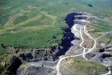
(Photo: GGAT Merthyr 060)
Cefn Cil-Sanws character area: largely unenclosed upland landscape.
Summary
A largely unenclosed upland landscape characterised by minor agricultural/industrial extraction.
Historical background
The historic landscape area of Cefn Cil-Sanws comprises unenclosed mountain north of Cefn-Coed-y-Cymmer. The area represents the southern tip of a far more extensive mountain area, which extends far beyond the boundaries of the historic landscape. Within the historic landscape, the area contains a number of characteristic features typical of the areas particular geological conditions, ie small local limestone quarries of 19th and early 20th century date, some with disused limekilns, associated with the tradition of applying lime to improve agricultural land. The area also contains features associated with a disused rifle range, extant in 1890, with various targets. Place name evidence indicates that the area may be associated with an early Christian church/monastic settlement (Cil or Church of Sanos, the sister of St Tydfil).