Historic Landscape
Characterisation
Merthyr Tydfil
023 Clyn-Mil Workings
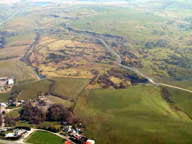
HLCA 023 Clyn-Mil Workings Area of enclosed upland; remains
of early ironstone and coal workings, largely surface workings; industrial
tramroad network and water management; Ancient Woodland; drystone and
hedged bank field boundaries; close association with adjacent areas.
(Photo: GGAT Merthyr 023)
Clyn-Mil Workings character area: extensive and well-preserved remains
of early surface workings of coal and ironstone.
Summary
An area of enclosed upland principally characterised by extensive and well-preserved remains of early surface workings of coal and ironstone, primarily levels and 'patch workings' associated with the Plymouth Iron Works. Along with the adjacent Ffos y Fran area (039), it can be considered to be of national importance.
Historical background
The historic landscape area of Clyn-Mil Workings is a surviving area of intensive late 18th/early 19th century ironstone workings associated with Anthony Hill and the Plymouth Iron Company; Waun Level lies just within the south western corner of the area.
The area was part of a large tract of enclosed upland named Coed Cae, woodland enclosure; the area as the name suggests was heavily wooded, and the southern half of the area retains significant remnants of Ancient Woodland to the present day. The enclosure, which formed part of the Clyn-Mil holding of the estate of Robert Henry Clive, leased to Anthony Hill in 1850 was typical of early post-medieval encroachment along the edge of the Common.
Cartographic evidence of 1813 indicated that Iron Mines were situated just to the north within the Cwmblacks/Pencoedcae area. By 1826, a network of tramroads and inclines, including the main Coedcae Incline, had been established throughout the area connecting the Plymouth Iron Works with various workings both within and beyond the area. These include ironstone levels and patch workings within the adjacent areas to the north and east, including HLCA 023 and within Cwmblacks.
The area had been intensively worked by the publication of the 1875 6-inch OS map, which detailed at least three ironstone levels, among others, small 'lobed' tips, a kiln, a gravel pit, trial shaft, well, reservoirs and leats, an airshaft, and other surface workings, such as quarries, or 'patch workings' and (to a lesser extent) crown pit workings. The Coedcae Incline and various tramroads connecting the ironstone workings of the area and the Plymouth Ironworks were detailed in 1875; numerous other tracks indicated, might suggest that a once far more extensive network of tramways and haul roads previously served the area. The cartographic evidence indicated that mining activity all but ends in the area between 1875 and 1905, probably with the closure of the Plymouth Ironworks in 1880.